Huron, South Dakota
Huron is a city in Beadle County, South Dakota, United States. It is the county seat of Beadle County.[7] The Huron Daily Plainsman, also referred to as the Plainsman, is the newspaper. The first settlement at Huron was made in 1880.[8] The city was named after the Huron Indians.[1] It is currently the seventh largest city in South Dakota, but it once was the fourth. In recent years Huron's population has once again started to grow after nearly 20 years of stagnation. A welcoming immigration policy coupled with an economic revival in the area has sparked development. A Walmart Supercenter opened in the mid 2000s. Since Walmart's opening more commercial and residential development has occurred with the completion of a new Runnings store (retailer specializing in farm and fleet products), and many new apartments, twin homes and houses.
Huron | |
|---|---|
| Huron, South Dakota | |
 "World's Largest Pheasant" sculpture on U.S. Highway 14 | |
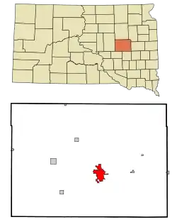 Location in Beadle County and the state of South Dakota | |
 Huron Location in the United States | |
| Coordinates: 44°21′33″N 98°13′5″W | |
| Country | United States |
| State | South Dakota |
| County | Beadle |
| Incorporated | 1883[1] |
| Government | |
| • Type | Commissioner Form |
| • Mayor | Gary Harrington (D) |
| Area | |
| • Total | 10.81 sq mi (27.99 km2) |
| • Land | 9.72 sq mi (25.17 km2) |
| • Water | 1.09 sq mi (2.82 km2) |
| Elevation | 1,280 ft (390 m) |
| Population | |
| • Total | 14,280 |
| • Estimate (2019)[4] | 13,380 |
| • Density | 1,376.68/sq mi (531.56/km2) |
| Time zone | UTC−6 (CST) |
| • Summer (DST) | UTC−5 (CDT) |
| ZIP code | 57350 and 57399 |
| Area code(s) | 605 |
| FIPS code | 46-31060[5] |
| GNIS feature ID | 1255722[6] |
| Airport code | HON |
| Website | City of Huron |
The greater Huron area is home to approximately 30,000 people. The population within the city limits was 14,280 according to the 2020 census. Huron was once in the running for capital of South Dakota but lost out to Pierre due to Pierre's positioning.[9] Huron is home to the South Dakota State Fair, which is held six days before Labor Day. It is also home to a statue known as "The World's Largest Pheasant",[10] which was refurbished in the summer of 2011. Huron has rail service, provided by the Rapid City, Pierre and Eastern Railroad.
Geography and climate
According to the United States Census Bureau, the city has a total area of 10.57 square miles (27.38 km2), of which 9.48 square miles (24.55 km2) is land and 1.09 square miles (2.82 km2) is water.[11]
Huron has been assigned the ZIP codes 57350 and 57399 and the FIPS place code 31060.
Huron has a humid continental climate, with hot, humid summers, cold, dry winters, and wide temperature extremes; it is part of USDA hardiness zone 4b.[12] The normal monthly mean temperature ranges from 16.7 °F (−8.5 °C) in January to 73.7 °F (23.2 °C) in July.[13] On average, there are 2.3 days that reach 100 °F (38 °C) or higher, 25 days that reach 90 °F (32 °C) or higher, 64 days that do not climb above freezing, 27 days with a low of 0 °F (−18 °C) or below, and 3.1 days that do not rise above 0 °F annually.[13] The average window for freezing temperatures is September 30 through May 5,[13] allowing a growing season of 147 days. Extreme temperatures officially range from −43 °F (−42 °C) on January 12, 1912, and January 8, 1887, up to 112 °F (44 °C) on July 10, 1966; the record cold daily maximum is −21 °F (−29 °C) on January 14, 1888, while, conversely, the record warm daily minimum is 82 °F (28 °C) on July 11, 1936.[13]
Precipitation is greatest in May and June and averages 22.9 in (580 mm) annually, but has ranged from 9.72 in (247 mm) in 1952 to 30.89 in (785 mm) in 2010.[13] Snowfall averages 43.9 in (112 cm) per season, and has historically ranged from 10.1 in (26 cm) in 1930–31 to 89.6 in (228 cm) in 2000–01;[13] the average window for measurable (≥0.1 in or 0.25 cm) snowfall is November 3 through April 11, although snow in October occurs several times per decade and snow in May is a much rarer event.[13]
| Climate data for Huron Regional Airport, South Dakota (Airport), 1981−2010 normals, extremes 1893−present[lower-alpha 1] | |||||||||||||
|---|---|---|---|---|---|---|---|---|---|---|---|---|---|
| Month | Jan | Feb | Mar | Apr | May | Jun | Jul | Aug | Sep | Oct | Nov | Dec | Year |
| Record high °F (°C) | 65 (18) |
71 (22) |
89 (32) |
97 (36) |
106 (41) |
109 (43) |
112 (44) |
110 (43) |
106 (41) |
102 (39) |
86 (30) |
71 (22) |
112 (44) |
| Average high °F (°C) | 26.8 (−2.9) |
31.8 (−0.1) |
43.7 (6.5) |
59.0 (15.0) |
70.2 (21.2) |
79.6 (26.4) |
86.0 (30.0) |
84.0 (28.9) |
74.7 (23.7) |
60.4 (15.8) |
43.0 (6.1) |
29.0 (−1.7) |
57.5 (14.2) |
| Average low °F (°C) | 6.6 (−14.1) |
11.4 (−11.4) |
22.6 (−5.2) |
34.0 (1.1) |
46.0 (7.8) |
55.9 (13.3) |
61.4 (16.3) |
59.2 (15.1) |
48.8 (9.3) |
35.4 (1.9) |
22.2 (−5.4) |
9.5 (−12.5) |
34.5 (1.4) |
| Record low °F (°C) | −43 (−42) |
−41 (−41) |
−25 (−32) |
−2 (−19) |
16 (−9) |
31 (−1) |
37 (3) |
33 (1) |
18 (−8) |
−6 (−21) |
−28 (−33) |
−34 (−37) |
−43 (−42) |
| Average precipitation inches (mm) | 0.50 (13) |
0.60 (15) |
1.46 (37) |
2.31 (59) |
3.11 (79) |
3.93 (100) |
2.92 (74) |
2.43 (62) |
2.46 (62) |
1.79 (45) |
0.87 (22) |
0.52 (13) |
22.90 (582) |
| Average snowfall inches (cm) | 7.3 (19) |
7.4 (19) |
8.9 (23) |
4.0 (10) |
trace | 0 (0) |
0 (0) |
0 (0) |
0 (0) |
1.1 (2.8) |
7.2 (18) |
8.0 (20) |
43.9 (112) |
| Average precipitation days (≥ 0.01 in) | 5.6 | 6.3 | 7.5 | 8.7 | 11.0 | 11.2 | 8.8 | 7.6 | 7.5 | 7.0 | 5.7 | 5.8 | 92.7 |
| Average snowy days (≥ 0.1 in) | 6.1 | 6.1 | 4.5 | 2.0 | 0 | 0 | 0 | 0 | 0 | 0.6 | 4.2 | 6.6 | 30.1 |
| Average relative humidity (%) | 71.2 | 73.7 | 73.3 | 66.3 | 66.3 | 68.3 | 65.8 | 66.6 | 67.7 | 66.8 | 72.8 | 74.0 | 69.4 |
| Mean monthly sunshine hours | 179.7 | 182.8 | 229.9 | 251.7 | 307.0 | 332.8 | 362.4 | 329.3 | 258.9 | 215.9 | 152.1 | 144.1 | 2,946.6 |
| Percent possible sunshine | 62 | 62 | 62 | 62 | 67 | 72 | 77 | 76 | 69 | 63 | 53 | 52 | 66 |
| Source: NOAA (relative humidity and sun 1961−1990),[13][15][16] The Weather Channel[17] | |||||||||||||
Demographics
| Historical population | |||
|---|---|---|---|
| Census | Pop. | %± | |
| 1880 | 164 | — | |
| 1890 | 3,038 | 1,752.4% | |
| 1900 | 2,793 | −8.1% | |
| 1910 | 5,791 | 107.3% | |
| 1920 | 8,302 | 43.4% | |
| 1930 | 10,946 | 31.8% | |
| 1940 | 10,843 | −0.9% | |
| 1950 | 12,788 | 17.9% | |
| 1960 | 14,180 | 10.9% | |
| 1970 | 14,299 | 0.8% | |
| 1980 | 13,000 | −9.1% | |
| 1990 | 12,448 | −4.2% | |
| 2000 | 11,893 | −4.5% | |
| 2010 | 12,592 | 5.9% | |
| 2019 (est.) | 13,380 | [4] | 6.3% |
| U.S. Decennial Census[18] | |||
2010 census
As of the census[3] of 2010, there were 12,592 people, 5,418 households, and 3,179 families residing in the city. The population density was 1,328.3 inhabitants per square mile (512.9/km2). There were 6,023 housing units at an average density of 635.3 per square mile (245.3/km2). The racial makeup of the city was 86.9% White, 1.0% African American, 1.2% Native American, 4.9% Asian, 0.1% Pacific Islander, 3.9% from other races, and 1.9% from two or more races. Hispanic or Latino of any race were 9.8% of the population.
There were 5,418 households, of which 28.7% had children under the age of 18 living with them, 44.4% were married couples living together, 9.8% had a female householder with no husband present, 4.4% had a male householder with no wife present, and 41.3% were non-families. 36.1% of all households were made up of individuals, and 15% had someone living alone who was 65 years of age or older. The average household size was 2.27 and the average family size was 2.94.
The median age in the city was 39.8 years. 24.1% of residents were under the age of 18; 8.7% were between the ages of 18 and 24; 22.8% were from 25 to 44; 26.4% were from 45 to 64; and 17.8% were 65 years of age or older. The gender makeup of the city was 49.4% male and 50.6% female.
2000 census
As of the census[5] of 2000, there were 11,893 people, 5,263 households, and 3,047 families residing in the city. The population density was 1,448.5 people per square mile (559.3/km2). There were 5,872 housing units at an average density of 715.2 per square mile (276.2/km2). The racial makeup of the city was 95.92% White, 0.96% African American, 1.29% Native American, 0.42% Asian, 0.03% Pacific Islander, 0.35% from other races, and 1.03% from two or more races. Hispanic or Latino of any race were 1.20% of the population.
There were 5,263 households, out of which 26.4% had children under the age of 18 living with them, 46.6% were married couples living together, 8.5% had a female householder with no husband present, and 42.1% were non-families. 37.3% of all households were made up of individuals, and 16.8% had someone living alone who was 65 years of age or older. The average household size was 2.18 and the average family size was 2.86.
As of 2000 the median income for a household in the city was $29,097. Males had a median income of $27,027 versus $19,921 for females. The per capita income for the city was $18,275.
Government
The City of Huron's type of government is "commissioner form". Under the commissioner form of government the board of commissioners consists of a mayor and four commissioners, who are all elected at large for three-year terms. The commission has control over all departments of the city and can make and enforce rules and regulations which it may see fit for the organization, management, and operation of the departments of the city. Responsibilities are divided into the following areas: Public Safety Commissioner, Public Works Commissioner, Utilities Commissioner, and Finance Commissioner with each commissioner having oversight in each respective area.
Huron has a federal building, field offices that is home to Social Security Administration, Western Area Power Administration, United States Fish and Wildlife Service, General Services Administration, Farm Service Agency and the USDA. Huron is also home to Area offices for state offices.
History
Huron, located in east central South Dakota, is a result of railroad and land booms in the 1880s. The early history of the town is closely linked with the Chicago and Northwestern Railway. At the direction of Marvin Hughitt, general manager of the railroad, the west bank of the James River was selected as the division headquarters of the railroad. The company gained title to 880 acres (3.6 km2) of land at that location. Huron was named for the Huron Indians.[19] Exactly who gave it the name was never established, apparently either Marvin Hughitt or someone in the Chicago office of the C&NW railroad company.
The original plat covered 11 blocks from 1st Street to 3rd Street and from Iowa Avenue SE to Ohio Avenue SW. Huron's first settler was John Cain, a practical printer from Troy, New York. He learned in Chicago, from the railroad people, that they would have their chief town and operating headquarters at their James River crossing.
From 1880 until the capital was permanently located at Pierre in 1904, Huron was in the thick of the fight for the honor of being the capital city. Campbell and Winter Parks are the only remaining properties that were once designated capital grounds. Located between the two parks, Victorian houses originally built around 1906 occupy the city block on the land originally slated for the capitol building.
Huron is the home to a handful of celebrities. Cheryl Ladd replaced Farrah Fawcett of the original Charlie's Angels. Gladys Pyle was the first female member of the South Dakota House of Representatives and the first Republican woman in the US Senate. Hubert H. Humphrey was the Democratic nominee for president in 1968 and served as vice president under Lyndon B. Johnson.
- Chronology:
- 1879 – The town site was located
- 1880 – Town site surveyed and platted
- 1881 – First town government formed - a board of four trustees, a town clerk, a justice of the peace, one marshal and a surveyor
- 1882 – Alderman system of government adopted
- 1883 – Incorporated as the City of Huron - the city still operates under the original charter and seal
- 1910 – Changed from alderman to city commission form of government
- 1935 – City manager form of government adopted
Notable people
- Adolphus W. Burtt, South Dakota Attorney General[20]
- Earl Caddock, wrestler. He had to leave as a child to be treated for tuberculosis.
- J. L. Carr, English novelist, taught at the public school in Huron in 1938–1939 and 1956–1957.
- Roxanne Conlin, Iowan politician, ran for senator in 2010.
- Patrick Davis, Republican political consultant and former director of the National Republican Senatorial Committee.
- John K. Fairbank, historian of China, was born in Huron in 1907.
- Archibald K. Gardner, former federal judge
- Bob Glanzer (1945-2020), member South Dakota House of Representatives 2017 until his death from COVID-19 in 2020, born in Huron
- Jennifer Jean Hart, one of the perpetrators of the Hart family crash[21]
- Candace Hilligoss, actress of the now-famous cult movie Carnival of Souls, was born in Huron in 1935.
- Muriel Humphrey, senator from Minnesota in 1978 and wife of Hubert Humphrey, was born in Huron on February 20, 1912.
- Raymond A. Johnson, aviation pioneer, worked at the Huron airport in latter 1940s.[22]
- Craig Kennedy, South Dakota state senator, 18th district was born here
- Cheryl Ladd, actress and singer born Cheryl Jean Stoppelmoor in Huron.
- Vernon C. Miller, prohibition gunman, bootlegger, bank robber and former sheriff of Beadle County lived in Huron from 1914 to 1922.
- Arthur L. Padrutt, Wisconsin politician.
- Gladys Pyle, First woman ever elected United States Senator from South Dakota was born in Huron on October 4, 1890.
- John L. Pyle, Attorney General of South Dakota, 1899–1902
- Mamie Shields Pyle President of the South Dakota Universal Franchise League when the state passed women's suffrage and the 19th Amendment.
- Mike Rounds, former South Dakota governor and current U.S. senator, was born in Huron on October 24, 1954, and left with his family when he was 3 years old.
- Chic Sale, actor and vaudevillian, born in Huron.[23]
- Ron Tschetter, former director of the Peace Corps was born here
- Fred M. Wilcox, South Dakota state senator
- Josh Haeder, 33rd State Treasurer of South Dakota.[24]
Education
The Huron School District has three public elementary schools, one middle school, and one high school. Huron High School's mascot is the "Tigers".
The principal of the Huron High School is Michael Radke, as of 2020–21 school year.
The current assistant principal of 2020–21 school year is Rodney Mittelstedt.
It was the home of Si Tanka University (formerly Huron College) from 1983 to 2005.
Huron is also home to a Catholic elementary school called Holy Trinity School, and a private Christian school on the north side of town called James Valley Christian School.
Entertainment
After the Si Tanka University closed, the city bought the Fine Arts Center and operates it as a theater for the community.
In 2005, The Huron Event Center was opened connecting the Arena and the Crossroads, a local hotel; the event center is owned by the city.
The State Fair is at the South Dakota State Fair Speedway.
In 2012, the city government built a new water park (Splash Central) on the property that Huron University (Si Tanka) once occupied.
Splash Central has an Olympic-sized pool, two large slides, a lazy river, and a large kids section.
Media
Television
| Channel (Digital) |
Callsign | Network | Owner | Web site |
|---|---|---|---|---|
| 5.1 | KDLV (Translator of KDLT) | NBC | Red River Broadcasting | |
| 5.2 | KDLV (Translator of KDLT) | Antenna TV | Red River Broadcasting | |
| 12.1 | KTTM (Satellite of KTTW) | Fox | Independent Communications | |
| 12.2 | KTTM (Satellite of KTTW) | This TV | Independent Communications | |
AM radio
| AM radio stations | |||||
|---|---|---|---|---|---|
| Frequency | Call sign | Name | Format | Owner | City |
| 1210 AM | KOKK | Dakota Country | Country | Dakota Communications | Huron |
| 1340 AM | KIJV | Tiger 95 | Hot AC | Dakota Communications | Huron |
FM radio
| FM radio stations | ||||||
|---|---|---|---|---|---|---|
| Frequency | Call sign | Name | Format | Owner | Target city/market | City of license |
| 88.7 FM | KVCH | VCY America | Christian | VCY America | Huron | Huron |
| 88.7 FM | K213CL | South Dakota Public Broadcasting | NPR | SD Board of Directors for Educational Telecommunications | Huron | Huron |
| 89.7 FM | K-LOVE | K-LOVE | Christian | Educational Media Foundation | Huron | Rocklin, California |
| 90.5 FM | K213CL | Moody Radio | Christian WJSO translator | Moody Bible Institute | Huron | Huron |
| 93.3 FM | KJRV | Big Jim 93.3 | Classic rock | Dakota Communications | Huron/Mitchell | Wessington Springs |
| 95.3 FM | K237EL | Tiger 95 | Hot AC KIJV-AM translator | Dakota Communications | Huron | Huron |
Transportation
U.S. Route 14 is an east–west route passing through the northern part of the city. It intersects with north–south South Dakota Highway 37 in the city. This was the historical designation of the north–south U.S. Route 281, which was later moved to a more direct route that passes about ten miles west of Huron.
The Rapid City, Pierre and Eastern Railroad runs east–west, with maintenance facilities and a working roundhouse in the city.
The Huron Regional Airport is city-owned. It has scheduled passenger flights operated by a commuter air carrier, Great Lakes Airlines, with Beechcraft 1900D commuter turboprop aircraft service to Denver.
Bibliography
- J.L. Carr (1957) The Old Timers. A social history of the way of life of the home-steading pioneers in the prairie states during the first few years of settlement, as shown by a typical community, the 'old-timers' of Beadle County in South Dakota. Huron, South Dakota: privately printed.
Notes
- Official records for Huron kept at downtown from July 1881 to 20 February 1939 and at Huron Regional Airport since 21 February 1939.[14]
References
- "History". City of Huron. Retrieved 2008-10-14.
- "2019 U.S. Gazetteer Files". United States Census Bureau. Retrieved July 30, 2020.
- "U.S. Census website". United States Census Bureau. Retrieved 2012-06-21.
- "Population and Housing Unit Estimates". United States Census Bureau. May 24, 2020. Retrieved May 27, 2020.
- "U.S. Census website". United States Census Bureau. Retrieved 2008-01-31.
- "US Board on Geographic Names". United States Geological Survey. October 25, 2007. Retrieved January 31, 2008.
- "Find a County". National Association of Counties. Archived from the original on May 31, 2011. Retrieved June 7, 2011.
- Federal Writers' Project (1940). South Dakota place-names, v.1-3. University of South Dakota. p. 43.
- "Biggest Cities South Dakota, United States".
- Brown, Greg; Jocelyn Sloan; Uther Draken (2005-07-24). "Huron, South Dakota - World's Largest Pheasant". RoadsideAmerica.com. Retrieved 2007-10-19.
- "US Gazetteer files 2010". United States Census Bureau. Archived from the original on 2012-01-24. Retrieved 2012-06-21.
- "USDA Plant Hardiness Zone Map". United States Department of Agriculture. Archived from the original on 2014-02-27. Retrieved 2014-06-01.
- "NOWData - NOAA Online Weather Data". National Oceanic and Atmospheric Administration. Retrieved 2013-02-18.
- ThreadEx
- "Station Name: SD HURON RGNL AP". National Oceanic and Atmospheric Administration. Retrieved 2013-03-11.
- "WMO Climate Normals for HURON/HURON REGIONAL, SD 1961–1990". National Oceanic and Atmospheric Administration. Retrieved 2014-03-10.
- "Monthly Averages for Huron, SD". The Weather Channel. Retrieved 2011-10-28.
- United States Census Bureau. "Census of Population and Housing". Retrieved September 23, 2013.
- History of the Origin of the Place Names in Nine Northwestern States. 1908. p. 11.
- "Aged Resident of Kalispell Dead". Great Falls Tribune. Great Falls, MT. January 10, 1917. p. 3 – via Newspapers.com.
- Young, Molly (April 2018). "Devonte Hart's mother: tracing her life from the Midwest to her drive off the California cliff". The Oregonian. Retrieved 2019-12-30.
- "Raymond Johnson named to Wyoming Aviation Hall of Fame, September 23, 2013". Retrieved September 26, 2013.
- Sirvaitis, Karen (1 September 2001). South Dakota. Lerner Publications. p. 69. ISBN 978-0-8225-4070-0.
- "About the Treasurer". Retrieved January 31, 2020.
- Schuster, Ryan (February 8, 2010). "Community profile: Huron, SD". Prairie Business Magazine. Archived from the original on January 26, 2016. Retrieved 20 February 2010.
External links
| Wikimedia Commons has media related to Huron, South Dakota. |
- Huron, SD government website
- Huron's Subreddit
- Huron Plainsman - local newspaper
- Local radio
- City Data - Detailed View
- Huron Public School
Municipalities and communities of Beadle County, South Dakota, United States | ||
|---|---|---|
| Cities | 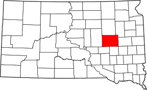 | |
| Towns | ||
| Townships |
| |
| CDP | ||
| Unincorporated communities |
| |
| Footnotes | ‡This populated place also has portions in an adjacent county or counties | |
| ||

38th Vice President of the United States (1964–1969) •
United States Senator from Minnesota (1949–1964, 1971–1978) | ||
| Political career | 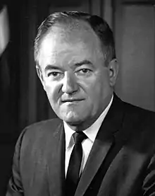 | |
| Electoral history | ||
| Legacy | ||
| Family and personal life | ||
| ||
| Authority control |
|---|