Andover, Minnesota
Andover is a city in Anoka County, Minnesota, United States. The population was 30,598 at the 2010 census.[6]
Andover | |
|---|---|
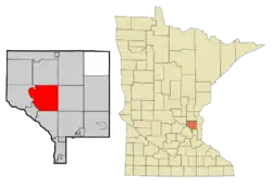 Location of the city of Andover within Anoka County, Minnesota | |
 Andover Location of the city of Andover within Anoka County, Minnesota  Andover Andover (the United States)  Andover Andover (North America) | |
| Coordinates: 45°14′00″N 93°17′29″W | |
| Country | United States |
| State | Minnesota |
| County | Anoka |
| Founded | 1857 |
| Incorporated (village) | 1972 |
| Incorporated (city) | November 12, 1972[1] |
| Government | |
| • Mayor | Julie Trude |
| Area | |
| • City | 34.84 sq mi (90.24 km2) |
| • Land | 33.88 sq mi (87.76 km2) |
| • Water | 0.96 sq mi (2.48 km2) 2.72% |
| Elevation | 889 ft (271 m) |
| Population | |
| • City | 30,598 |
| • Estimate (2019)[4] | 33,140 |
| • Density | 978.01/sq mi (377.62/km2) |
| • Metro | 3,524,583 |
| Time zone | UTC-6 |
| • Summer (DST) | UTC-5 (Central) |
| ZIP code | 55304 |
| Area code(s) | 763 |
| FIPS code | 27-01486 |
| GNIS feature jk | 0654568[5] |
| Website | City of Andover |
Geography
According to the United States Census Bureau, the city has a total area of 34.83 square miles (90.21 km2), of which 33.88 square miles (87.75 km2) is land and 0.95 square miles (2.46 km2) is water.[7] County Roads 9, 18, 78, and 116 are the main routes in the community. U.S. Highway 10 is nearby.
Crooked Lake is the only fully recreational lake in Andover. It is on the southern border of the city with the majority of the lake in neighboring Coon Rapids.
History
Ham Lake Township split from Andover, known as Grow Township at the time, in 1871.[8]
Once a stop on the Great Northern Railway, Andover was established as a city in 1976.[9]
Demographics
| Historical population | |||
|---|---|---|---|
| Census | Pop. | %± | |
| 1860 | 330 | — | |
| 1870 | 396 | 20.0% | |
| 1880 | 419 | 5.8% | |
| 1890 | 485 | 15.8% | |
| 1900 | 721 | 48.7% | |
| 1910 | 614 | −14.8% | |
| 1920 | 626 | 2.0% | |
| 1930 | 508 | −18.8% | |
| 1940 | 656 | 29.1% | |
| 1950 | 757 | 15.4% | |
| 1960 | 1,402 | 85.2% | |
| 1970 | 3,830 | 173.2% | |
| 1980 | 9,387 | 145.1% | |
| 1990 | 15,216 | 62.1% | |
| 2000 | 26,588 | 74.7% | |
| 2010 | 30,598 | 15.1% | |
| 2019 (est.) | 33,140 | [4] | 8.3% |
| U.S. Decennial Census[10] 2018 Estimate[11] | |||
2010 census
At the 2010 census there were 30,598 people, 9,811 households, and 8,357 families living in the city. The population density was 903.1 inhabitants per square mile (348.7/km2). There were 10,091 housing units at an average density of 297.8 per square mile (115.0/km2). The racial makeup of the city was 93.2% White, 1.7% African American, 0.3% Native American, 2.2% Asian, 0.6% from other races, and 1.9% from two or more races. Hispanic or Latino of any race were 2.0%.[3]
Of the 9,811 households 47.6% had children under the age of 18 living with them, 74.2% were married couples living together, 7.1% had a female householder with no husband present, 3.9% had a male householder with no wife present, and 14.8% were non-families. 10.6% of households were one person and 3.4% were one person aged 65 or older. The average household size was 3.11 and the average family size was 3.35.
The median age was 37.3 years. 30.4% of residents were under the age of 18; 7.6% were between the ages of 18 and 24; 25.5% were from 25 to 44; 29.9% were from 45 to 64; and 6.7% were 65 or older. The gender makeup of the city was 50.7% male and 49.3% female.
2000 census
At the 2000 census, there were 26,588 people, 8,107 households, and 7,150 families living in the city. The population density was 779.6 people per square mile (301.0/km2). There were 8,205 housing units at an average density of 240.6 per square mile (92.9/km2). The racial makeup of the city was 96.48% White, 0.54% African American, 0.35% Native American, 1.08% Asian, 0.02% Pacific Islander, 0.32% from other races, and 1.21% from two or more races. Hispanic or Latino of any race were 1.05% of the population.
Of the 8,107 households 55.1% had children under the age of 18 living with them, 80.0% were married couples living together, 5.5% had a female householder with no husband present, and 11.8% were non-families. 8.4% of households were one person and 2.3% were one person aged 65 or older. The average household size was 3.28 and the average family size was 3.48.
The age distribution was 35.5% under the age of 18, 6.0% from 18 to 24, 36.4% from 25 to 44, 19.2% from 45 to 64, and 2.9% 65 or older. The median age was 32 years. For every 100 females, there were 103.4 males. For every 100 females age 18 and over, there were 102.5 males.
The median household income was $76,241 and the median family income was $78,785. Males had a median income of $50,248 versus $33,814 for females. The per capita income for the city was $26,317. About 1.2% of families and 2.0% of the population were below the poverty line, including 2.0% of those under age 18 and 4.0% of those age 65 or over.
City Celebration
The annual city celebration is the Andover Family Fun Fest, held near the beginning of July on and around the grounds of City Hall, Andover Elementary School, and Sunshine Park. Events include a 5K fun run, a street dance, a parade, and a fireworks show.[12]
The 25th Annual Andover Family Fun Fest was held on July 13 and 14, 2018.
Education
Andover is part of Minnesota's Anoka-Hennepin School District 11. District 11 schools within Andover's boundaries include Andover Elementary School, Crooked Lake Elementary School, Rum River Elementary School,[13] Oak View Middle School,[14] and Andover High School. In addition, a small strip of the northern part of the city is part of St. Francis Area Schools (Independent School District 15). Legacy Christian Academy is a K-12 college preparatory school.[15]
Notable people
- Mike Morin (born 1991), major league baseball pitcher
- Maddie Rooney (born 1997), Olympic ice hockey goaltender
References
- "Guide to Andover Minnesota". www.lakesnwoods.com. Retrieved 10 April 2018.
- "2019 U.S. Gazetteer Files". United States Census Bureau. Retrieved July 26, 2020.
- "U.S. Census website". United States Census Bureau. Retrieved 2012-11-13.
- "Population and Housing Unit Estimates". United States Census Bureau. May 24, 2020. Retrieved May 27, 2020.
- "US Board on Geographic Names". United States Geological Survey. 2007-10-25. Retrieved 2008-01-31.
- "2010 Census Redistricting Data (Public Law 94-171) Summary File". American FactFinder. U.S. Census Bureau, 2010 Census. Retrieved 23 April 2011.
- "US Gazetteer files 2010". United States Census Bureau. Archived from the original on 2012-01-25. Retrieved 2012-11-13.
- https://www2.census.gov/library/publications/decennial/1880/vol-01-population/1880_v1-10.pdf
- Upham, Warren (2001). Minnesota Place Names: A Geographical Encyclopedia. Minnesota Historical Society Press. p. 23. ISBN 9780873513968.
- United States Census Bureau. "Census of Population and Housing". Retrieved October 28, 2014.
- "Population Estimates". United States Census Bureau. Retrieved June 8, 2018.
- "Andover FamilyFun Fest | Andover, MN - Official Website". www.andovermn.gov. Retrieved 2018-02-16.
- "Archived copy". Archived from the original on 2013-03-03. Retrieved 2013-04-15.CS1 maint: archived copy as title (link)
- "Archived copy". Archived from the original on 2013-03-03. Retrieved 2013-04-15.CS1 maint: archived copy as title (link)
- https://www.lcamn.org/
External links
Municipalities and communities of Anoka County, Minnesota, United States | ||
|---|---|---|
| Cities | 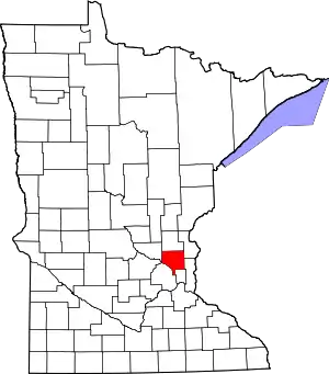 Map of Minnesota highlighting Anoka County | |
| Township | ||
| CDP | ||
| Unincorporated community | ||
| Ghost towns/Neighborhoods | ||
| Footnotes | ‡This populated place also has portions in an adjacent county or counties | |
| ||

| Authority control |
|---|