Meeker County, Minnesota
Meeker County is a county in the U.S. state of Minnesota. As of the 2010 United States Census, the population was 23,300.[2] Its county seat is Litchfield.[3]
Meeker County | |
|---|---|
 | |
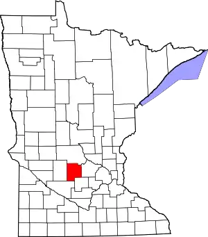 Location within the U.S. state of Minnesota | |
 Minnesota's location within the U.S. | |
| Coordinates: 45°07′N 94°32′W | |
| Country | |
| State | |
| Founded | February 23, 1856[1] |
| Named for | Bradley B. Meeker, an associate justice of Minnesota Territorial Court |
| Seat | Litchfield |
| Largest city | Litchfield |
| Area | |
| • Total | 645 sq mi (1,670 km2) |
| • Land | 608 sq mi (1,570 km2) |
| • Water | 37 sq mi (100 km2) 5.7%% |
| Population (2010) | |
| • Total | 23,300 |
| • Estimate (2019) | 23,222 |
| • Density | 38.1/sq mi (14.7/km2) |
| Time zone | UTC−6 (Central) |
| • Summer (DST) | UTC−5 (CDT) |
| Congressional district | 7th |
| Website | www |
History
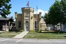
The Wisconsin Territory was established by the federal government effective July 3, 1836, and existed until its eastern portion was granted statehood (as Wisconsin) in 1848. The federal government set up the Minnesota Territory effective March 3, 1849. The newly organized territorial legislature created nine counties across the territory in October of that year. One of those original counties, Dakota, had portions partitioned off to create Cass (1851), Nicollet (1853), Pierce (1853), and Sibley (1853) counties. In 1855 portions of those counties were carved out to create Davis, and on February 23, 1856, the territorial legislature created Meeker County from a portion of Davis. It was named for Bradley B. Meeker (1813-1873), who served on the Minnesota Territorial Supreme Court from 1849 to 1853.[4] The area of Forest City was first settled in the 1850s, and the village was named the county seat in 1856. It was platted as Forest City in 1857.
In 1856 the first settlers moved into the future Litchfield; the resulting settlement was named Ness. The area grew, and with the arrival of a spur from the St. Paul and Pacific Railroad, the vote was taken to move the county seat to this area in the fall of 1869. Upon being platted in 1869, the city was renamed Litchfield.[5]
On March 20, 1858, the western portion of Meeker County was partitioned off to create Kandiyohi County. Meeker County's boundaries have remained unchanged since then.
Geography
Meeker County's terrain consists of low rolling hills, lightly wooded and heavily dotted with lakes and ponds. The available area is devoted to agriculture.[6] The terrain slopes to the south and east,[7] with its highest point just southwest of Lake Hope, 7.9 miles (12.7 km) west-southwest of Litchfield, at 1,261' (384m) ASL.[8] The county has a total area of 645 square miles (1,670 km2), of which 608 square miles (1,570 km2) is land and 37 square miles (96 km2) (5.7%) is water.[9]
Major highways
Adjacent counties
- Stearns County - north
- Wright County - east
- McLeod County - southeast
- Renville County - southwest
- Kandiyohi County - west
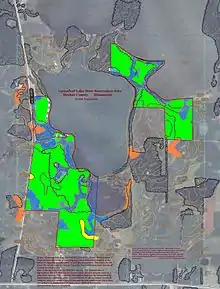
Protected areas[6]
- Acton State Wildlife Management Area
- Greenleaf Lake State Recreation Area
- Greenleaf State Wildlife Management Area
- Knapp State Wildlife Management Area (part)
- Madsen State Wildlife Management Area
- Popular State Wildlife Management Area
- Wieker State Wildlife Management Area
Demographics
| Historical population | |||
|---|---|---|---|
| Census | Pop. | %± | |
| 1860 | 928 | — | |
| 1870 | 6,090 | 556.3% | |
| 1880 | 11,739 | 92.8% | |
| 1890 | 15,456 | 31.7% | |
| 1900 | 17,753 | 14.9% | |
| 1910 | 17,022 | −4.1% | |
| 1920 | 18,103 | 6.4% | |
| 1930 | 17,914 | −1.0% | |
| 1940 | 19,277 | 7.6% | |
| 1950 | 18,966 | −1.6% | |
| 1960 | 18,887 | −0.4% | |
| 1970 | 18,387 | −2.6% | |
| 1980 | 20,594 | 12.0% | |
| 1990 | 20,846 | 1.2% | |
| 2000 | 22,644 | 8.6% | |
| 2010 | 23,300 | 2.9% | |
| 2019 (est.) | 23,222 | [11] | −0.3% |
| US Decennial Census[12] 1790-1960[13] 1900-1990[14] 1990-2000[15] 2010-2019[2] | |||
2000 census
As of the 2000 United States Census, there were 22,644 people, 8,590 households, and 6,133 families in the county. The population density was 37.2/sqmi (14.4/km2). There were 9,821 housing units at an average density of 16.2/sqmi (6.24/km2). The racial makeup of the county was 97.35% White, 0.19% Black or African American, 0.18% Native American, 0.40% Asian, 1.40% from other races, and 0.48% from two or more races. 2.15% of the population were Hispanic or Latino of any race. 45.8% were of German, 12.2% Swedish and 11.3% Norwegian ancestry.
There were 8,590 households, out of which 33.70% had children under the age of 18 living with them, 61.50% were married couples living together, 6.30% had a female householder with no husband present, and 28.60% were non-families. 24.40% of all households were made up of individuals, and 12.00% had someone living alone who was 65 years of age or older. The average household size was 2.58 and the average family size was 3.07.
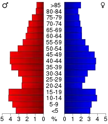
The county population contained 27.00% under the age of 18, 7.40% from 18 to 24, 26.40% from 25 to 44, 23.00% from 45 to 64, and 16.30% who were 65 years of age or older. The median age was 38 years. For every 100 females there were 101.70 males. For every 100 females age 18 and over, there were 98.90 males.
The median income for a household in the county was $40,908, and the median income for a family was $47,923. Males had a median income of $33,157 versus $22,743 for females. The per capita income for the county was $18,628. About 4.70% of families and 7.10% of the population were below the poverty line, including 6.40% of those under age 18 and 13.80% of those age 65 or over.
Communities
Cities
- Cedar Mills
- Cosmos
- Darwin
- Dassel
- Eden Valley (part)
- Grove City
- Kingston
- Litchfield (county seat)
- Watkins
Unincorporated communities
Townships
- Acton Township
- Cedar Mills Township
- Collinwood Township
- Cosmos Township
- Danielson Township
- Darwin Township
- Dassel Township
- Ellsworth Township
- Forest City Township
- Forest Prairie Township
- Greenleaf Township
- Harvey Township
- Kingston Township
- Litchfield Township
- Manannah Township
- Swede Grove Township
- Union Grove Township
Politics
Meeker County usually votes Republican. In 78% of national elections since 1980 the county selected the Republican Party candidate (as of 2016).
| Year | Republican | Democratic | Third parties |
|---|---|---|---|
| 2016 | 66.0% 8,104 | 26.0% 3,191 | 8.0% 987 |
| 2012 | 56.6% 6,913 | 40.7% 4,969 | 2.7% 332 |
| 2008 | 53.7% 6,737 | 42.9% 5,380 | 3.4% 428 |
| 2004 | 55.6% 6,854 | 42.9% 5,292 | 1.5% 188 |
| 2000 | 51.7% 5,520 | 41.3% 4,402 | 7.0% 750 |
| 1996 | 35.6% 3,428 | 47.0% 4,531 | 17.4% 1,680 |
| 1992 | 33.2% 3,497 | 36.6% 3,861 | 30.2% 3,182 |
| 1988 | 51.5% 4,999 | 46.8% 4,544 | 1.7% 164 |
| 1984 | 56.7% 5,511 | 42.8% 4,156 | 0.6% 53 |
| 1980 | 49.9% 5,032 | 42.0% 4,238 | 8.2% 825 |
| 1976 | 42.0% 4,097 | 54.3% 5,295 | 3.8% 369 |
| 1972 | 57.1% 5,097 | 40.3% 3,601 | 2.6% 235 |
| 1968 | 46.5% 4,044 | 48.4% 4,213 | 5.1% 447 |
| 1964 | 37.0% 3,099 | 62.9% 5,270 | 0.1% 9 |
| 1960 | 56.7% 4,857 | 43.0% 3,678 | 0.3% 25 |
| 1956 | 58.5% 4,738 | 41.4% 3,348 | 0.1% 11 |
| 1952 | 66.8% 5,750 | 32.9% 2,833 | 0.3% 25 |
| 1948 | 44.9% 3,620 | 53.7% 4,333 | 1.4% 112 |
| 1944 | 57.3% 4,302 | 42.1% 3,159 | 0.6% 45 |
| 1940 | 57.9% 5,026 | 41.6% 3,615 | 0.5% 45 |
| 1936 | 32.9% 2,479 | 56.3% 4,242 | 10.9% 821 |
| 1932 | 31.8% 2,273 | 66.1% 4,723 | 2.1% 151 |
| 1928 | 59.6% 4,175 | 39.4% 2,761 | 0.9% 66 |
| 1924 | 45.5% 2,757 | 6.0% 365 | 48.5% 2,942 |
| 1920 | 78.4% 4,693 | 14.7% 878 | 6.9% 415 |
| 1916 | 52.7% 1,780 | 43.7% 1,475 | 3.6% 123 |
| 1912 | 17.3% 560 | 34.0% 1,099 | 48.7% 1,576 |
| 1908 | 61.2% 1,928 | 35.3% 1,111 | 3.5% 110 |
| 1904 | 73.9% 2,327 | 22.0% 692 | 4.2% 132 |
| 1900 | 58.8% 2,032 | 37.6% 1,300 | 3.6% 126 |
| 1896 | 56.3% 2,094 | 41.4% 1,538 | 2.3% 86 |
| 1892 | 42.1% 1,274 | 37.9% 1,146 | 20.1% 607 |
References
- "Minnesota Place Names". Minnesota Historical Society. Archived from the original on June 20, 2012. Retrieved March 18, 2014.
- "State & County QuickFacts". United States Census Bureau. Archived from the original on June 7, 2011. Retrieved September 1, 2013.
- "Find a County". National Association of Counties. Archived from the original on May 31, 2011. Retrieved 7 June 2011.
- Gannett, Henry (1905). The Origin of Certain Place Names in the United States. U.S. Government Printing Office. p. 204.
- Upham, Warren. Minnesota Geographic Names (1920), pp. 338-340 (accessed April 26, 2019)
- Meeker County MN Google Maps (accessed April 26, 2019)
- ""Find an Altitude/Meeker County MN" Google Maps (accessed April 26, 2019)". Archived from the original on May 21, 2019. Retrieved 26 April 2019.
- Meeker County High Point, PeakBagger.com (accessed 26 April 2019)
- "2010 Census Gazetteer Files". US Census Bureau. August 22, 2012. Archived from the original on September 21, 2013. Retrieved October 21, 2014.
- Nelson, Steven (2011). Savanna Soils of Minnesota. Minnesota: Self. pp. 49-52. ISBN 978-0-615-50320-2.
- "Population and Housing Unit Estimates". Retrieved March 26, 2020.
- "US Decennial Census". US Census Bureau. Archived from the original on April 26, 2015. Retrieved October 21, 2014.
- "Historical Census Browser". University of Virginia Library. Retrieved October 21, 2014.
- "Population of Counties by Decennial Census: 1900 to 1990". US Census Bureau. Retrieved October 21, 2014.
- "Census 2000 PHC-T-4. Ranking Tables for Counties: 1990 and 2000" (PDF). US Census Bureau. Retrieved October 21, 2014.
- Leip, David. "Atlas of US Presidential Elections". uselectionatlas.org. Retrieved October 9, 2018.
External links
Places adjacent to Meeker County, Minnesota | ||||||||||
|---|---|---|---|---|---|---|---|---|---|---|
| ||||||||||
Municipalities and communities of Meeker County, Minnesota, United States | ||
|---|---|---|
| Cities | Map of Minnesota highlighting Meeker County | |
| Townships | ||
| Unincorporated communities | ||
| Footnotes | ‡This populated place also has portions in an adjacent county or counties | |
| ||

| Authority control |
|---|