Grant County, Minnesota
Grant County is a county in the U.S. state of Minnesota. As of the 2010 United States Census, the population was 6,018.[1] Its county seat is Elbow Lake.[2]
Grant County | |
|---|---|
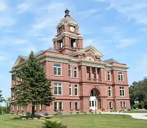 Grant County Courthouse | |
 Seal | |
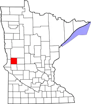 Location within the U.S. state of Minnesota | |
 Minnesota's location within the U.S. | |
| Coordinates: 45°56′N 96°01′W | |
| Country | |
| State | |
| Founded | March 6, 1868 (created) 1874 (organized) |
| Named for | Ulysses S. Grant |
| Seat | Elbow Lake |
| Largest city | Elbow Lake |
| Area | |
| • Total | 575 sq mi (1,490 km2) |
| • Land | 548 sq mi (1,420 km2) |
| • Water | 27 sq mi (70 km2) 4.7%% |
| Population (2010) | |
| • Total | 6,018 |
| • Estimate (2019) | 5,972 |
| • Density | 11.0/sq mi (4.2/km2) |
| Time zone | UTC−6 (Central) |
| • Summer (DST) | UTC−5 (CDT) |
| Congressional district | 7th |
| Website | www |
History
The county was created on March 6, 1868. It was named for Civil War General and US President Ulysses S. Grant.[3][4] Its government was organized in 1874.[3]
Geography
The Chippewa River flows generally southward through the eastern part of Grant County. The Mustinka River flows south and then west-southwest through the upper and central parts of western Grant County. The terrain consists of low rolling hills dotted with lakes, its usable areas devoted to agriculture.[5] The terrain generally slopes to the south and east; its highest point is on its upper eastern border, at 1,375' (409m) ASL.[6] The county has an area of 575 square miles (1,490 km2), of which 548 square miles (1,420 km2) is land and 27 square miles (70 km2) (4.7%) is water.[7]
Major highways
Adjacent counties
- Otter Tail County - north
- Douglas County - east
- Pope County - southeast
- Stevens County - south
- Traverse County - southwest
- Wilkin County - northwest
Protected areas[5]
- Alvstad State Wildlife Management Area
- Berksow State Wildlife Management Area
- Chippewa State Wildlife Management Area
- Helsene State Wildlife Management Area
- Isaacson State Wildlife Management Area
- Kube-Swift State Wildlife Management Area
- Malsville State Wildlife Management Area
- Marple State Wildlife Management Area
- Mustinka State Wildlife Management Area
- Storm-Bordson State Wildlife Management Area
- Wilts State Wildlife Management Area
Demographics
| Historical population | |||
|---|---|---|---|
| Census | Pop. | %± | |
| 1870 | 340 | — | |
| 1880 | 3,004 | 783.5% | |
| 1890 | 6,875 | 128.9% | |
| 1900 | 8,935 | 30.0% | |
| 1910 | 9,114 | 2.0% | |
| 1920 | 9,788 | 7.4% | |
| 1930 | 9,558 | −2.3% | |
| 1940 | 9,828 | 2.8% | |
| 1950 | 9,542 | −2.9% | |
| 1960 | 8,870 | −7.0% | |
| 1970 | 7,462 | −15.9% | |
| 1980 | 7,171 | −3.9% | |
| 1990 | 6,246 | −12.9% | |
| 2000 | 6,289 | 0.7% | |
| 2010 | 6,018 | −4.3% | |
| 2019 (est.) | 5,972 | [9] | −0.8% |
| US Decennial Census[10] 1790-1960[11] 1900-1990[12] 1990-2000[13] 2010-2019[1] | |||
2000 census
As of the 2000 United States Census,[14] there were 6,289 people, 2,534 households, and 1,740 families in the county. The population density was 11.6/sqmi (4.50/km2). There were 3,098 housing units at an average density of 5.74/sqmi (2.22/km2). The racial makeup of the county was 98.28% White, 0.21% Black or African American, 0.27% Native American, 0.19% Asian, 0.30% from other races, and 0.75% from two or more races. 0.52% of the population were Hispanic or Latino of any race. 41.2% were of Norwegian, 30.0% German and 7.4% Swedish ancestry.
There were 2,534 households, out of which 29.20% had children under the age of 18 living with them, 59.00% were married couples living together, 6.50% had a female householder with no husband present, and 31.30% were non-families. 28.00% of all households were made up of individuals, and 16.50% had someone living alone who was 65 years of age or older. The average household size was 2.40 and the average family size was 2.94.
The county population contained 23.90% under the age of 18, 6.90% from 18 to 24, 23.10% from 25 to 44, 23.20% from 45 to 64, and 22.90% who were 65 years of age or older. The median age was 42 years. For every 100 females there were 94.50 males. For every 100 females age 18 and over, there were 94.30 males.
The median income for a household in the county was $33,775, and the median income for a family was $42,214. Males had a median income of $28,428 versus $20,240 for females. The per capita income for the county was $17,131. About 6.00% of families and 8.40% of the population were below the poverty line, including 9.50% of those under age 18 and 9.90% of those age 65 or over.
Government and politics
Grant County is a swing district that has leaned Republican in recent elections. As of 2016, the county has selected the Republican presidential candidate in 60% of national elections from 1980 inclusive.
| Year | Republican | Democratic | Third parties |
|---|---|---|---|
| 2016 | 59.4% 2,063 | 31.8% 1,105 | 8.8% 305 |
| 2012 | 50.1% 1,748 | 47.2% 1,647 | 2.6% 92 |
| 2008 | 45.7% 1,646 | 51.3% 1,850 | 3.0% 109 |
| 2004 | 49.6% 1,893 | 48.6% 1,856 | 1.8% 70 |
| 2000 | 49.8% 1,804 | 41.6% 1,507 | 8.6% 313 |
| 1996 | 36.1% 1,284 | 50.7% 1,806 | 13.3% 472 |
| 1992 | 32.8% 1,201 | 42.6% 1,561 | 24.7% 904 |
| 1988 | 46.0% 1,693 | 53.0% 1,950 | 0.9% 34 |
| 1984 | 52.8% 2,111 | 46.7% 1,867 | 0.4% 17 |
| 1980 | 48.1% 2,054 | 42.7% 1,822 | 9.3% 396 |
| 1976 | 37.7% 1,635 | 60.5% 2,624 | 1.8% 79 |
| 1972 | 46.8% 1,899 | 51.4% 2,085 | 1.7% 70 |
| 1968 | 47.1% 1,929 | 48.4% 1,982 | 4.5% 184 |
| 1964 | 39.7% 1,734 | 60.3% 2,631 | 0.0% 1 |
| 1960 | 48.9% 2,239 | 51.0% 2,333 | 0.1% 4 |
| 1956 | 49.4% 2,064 | 50.4% 2,107 | 0.1% 6 |
| 1952 | 59.5% 2,665 | 40.0% 1,791 | 0.5% 22 |
| 1948 | 40.8% 1,789 | 54.2% 2,378 | 5.0% 221 |
| 1944 | 48.9% 1,898 | 50.8% 1,969 | 0.3% 12 |
| 1940 | 51.3% 2,443 | 48.1% 2,291 | 0.6% 30 |
| 1936 | 38.4% 1,566 | 57.9% 2,358 | 3.7% 151 |
| 1932 | 29.2% 1,148 | 68.7% 2,702 | 2.2% 85 |
| 1928 | 54.3% 2,057 | 44.6% 1,687 | 1.1% 42 |
| 1924 | 49.2% 1,674 | 3.5% 118 | 47.3% 1,610 |
| 1920 | 75.8% 2,427 | 16.7% 533 | 7.6% 242 |
| 1916 | 49.2% 878 | 43.6% 778 | 7.2% 129 |
| 1912 | 9.4% 146 | 24.4% 381 | 66.2% 1,033 |
| 1908 | 70.0% 1,099 | 24.0% 376 | 6.0% 94 |
| 1904 | 87.7% 1,209 | 7.4% 102 | 4.9% 68 |
| 1900 | 65.8% 1,062 | 28.2% 456 | 6.0% 97 |
| 1896 | 56.3% 1,002 | 41.5% 739 | 2.2% 39 |
| 1892 | 55.4% 776 | 22.8% 319 | 21.9% 307 |
| Position | Name | District | |
|---|---|---|---|
| Commissioner | Troy Johnson | District 1 | |
| Commissioner | Dwight Walvatne | District 2 | |
| Commissioner | Keith Swanson | District 3 | |
| Commissioner | Bill LaValley | District 4 | |
| Commissioner and Chairperson | Doyle Sperr | District 5 | |
| Position | Name | Affiliation | District | |
|---|---|---|---|---|
| Senate | Torrey Westrom[17] | Republican | District 12 | |
| House of Representatives | Jeff Backer[18] | Republican | District 12A | |
| Position | Name | Affiliation | District | |
|---|---|---|---|---|
| House of Representatives | Collin Peterson[19] | Democrat | 7th | |
| Senate | Amy Klobuchar[20] | Democrat | N/A | |
| Senate | Tina Smith[21] | Democrat | N/A | |
References
- "State & County QuickFacts". United States Census Bureau. Archived from the original on June 7, 2011. Retrieved August 31, 2013.
- "Find a County". National Association of Counties. Archived from the original on May 31, 2011. Retrieved June 7, 2011.
- "Minnesota Place Names". Minnesota Historical Society. p. 213. Retrieved March 9, 2019.
- Gannett, Henry (1905). The Origin of Certain Place Names in the United States. Govt. Print. Off. p. 141.
- Grant County MN Google Maps (accessed 9 March 2019)
- ""Find an Altitude/Grant County MN" Google Maps (accessed 9 March 2019)". Archived from the original on May 21, 2019. Retrieved March 9, 2019.
- "2010 Census Gazetteer Files". US Census Bureau. August 22, 2012. Archived from the original on October 6, 2014. Retrieved October 15, 2014.
- Nelson, Steven (2011). Savanna Soils of Minnesota. Minnesota: Self. pp. 65-67. ISBN 978-0-615-50320-2.
- "Population and Housing Unit Estimates". Retrieved March 26, 2020.
- "US Decennial Census". US Census Bureau. Retrieved October 15, 2014.
- "Historical Census Browser". University of Virginia Library. Retrieved October 15, 2014.
- "Population of Counties by Decennial Census: 1900 to 1990". US Census Bureau. Retrieved October 15, 2014.
- "Census 2000 PHC-T-4. Ranking Tables for Counties: 1990 and 2000" (PDF). US Census Bureau. Retrieved October 15, 2014.
- "U.S. Census website". US Census Bureau. Retrieved January 31, 2008.
- Leip, David. "Atlas of US Presidential Elections". uselectionatlas.org. Retrieved September 18, 2018.
- "County Commissioners | Grant County, MN - Official Website". www.co.grant.mn.us. Retrieved June 24, 2020.
- "MN State Senate". www.senate.mn. Retrieved June 24, 2020.
- "Rep. Jeff Backer (12A) - Minnesota House of Representatives". www.house.leg.state.mn.us. Retrieved June 24, 2020.
- "Congressman Collin Peterson". Congressman Collin Peterson. Retrieved June 24, 2020.
- "U.S. Senator Amy Klobuchar". www.klobuchar.senate.gov. Retrieved June 24, 2020.
- "Home". Senator Tina Smith. Retrieved June 24, 2020.
External links
Places adjacent to Grant County, Minnesota | ||||||||||
|---|---|---|---|---|---|---|---|---|---|---|
| ||||||||||
Municipalities and communities of Grant County, Minnesota, United States | ||
|---|---|---|
| Cities | Map of Minnesota highlighting Grant County | |
| Townships | ||
| Unincorporated communities | ||
| Former communities | ||
| Footnotes | ‡This populated place also has portions in an adjacent county or counties | |
| ||

| Authority control |
|---|