Roseau County, Minnesota
Roseau County (/roʊˈzoʊ/) is a county in the northwestern part of the U.S. state of Minnesota, along the Canada–US border. As of the 2010 United States Census, the population was 15,629.[1] Its county seat is Roseau.[2] Roseau County borders the Canadian province of Manitoba.
Roseau County | |
|---|---|
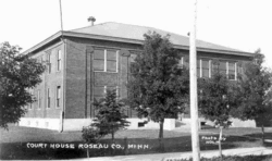 Postcard. Roseau County Courthouse. | |
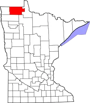 Location within the U.S. state of Minnesota | |
 Minnesota's location within the U.S. | |
| Coordinates: 48°46′N 95°48′W | |
| Country | |
| State | |
| Founded | December 31, 1894 |
| Named for | Roseau River |
| Seat | Roseau |
| Largest city | Roseau |
| Area | |
| • Total | 1,678 sq mi (4,350 km2) |
| • Land | 1,672 sq mi (4,330 km2) |
| • Water | 6.5 sq mi (17 km2) 0.4%% |
| Population (2010) | |
| • Total | 15,629 |
| • Estimate (2019) | 15,165 |
| • Density | 9.17/sq mi (3.54/km2) |
| Time zone | UTC−6 (Central) |
| • Summer (DST) | UTC−5 (CDT) |
| Congressional district | 7th |
| Website | www |
Part of the Red Lake Indian Reservation is in Roseau County.
History
Roseau County was once the home of many Ojibwe, Sioux, and Mandan tribes. Archeologists have found artifacts within the county belonging to these tribes that date back 7,200 years.[3] More recent history includes fur trappers and European-based explorers. By 1822, a fur-trading post was established in the area. In 1885, the future Roseau City hosted four settlers; by 1895 there were 600, and the area was incorporated as Roseau City.[4]
By the mid-1880s the early settlers of eastern Kittson County were feeling the disadvantage of their location, far from the county seat, and petitioned the government for a separate county. On December 31, 1894,[5] Governor Knute Nelson proclaimed the eastern portion of Kittson a new county, to be named Roseau.[6] On February 11, 1896, the next governor, David Marston Clough, added part of Beltrami County to Roseau County. Roseau City was named the county seat.[4]
Geography
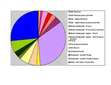
Roseau County is in far northern Minnesota. Its northern boundary abuts Canada. The Roseau River drains the upper part of the county, flowing west into Kittson County on its way to the Hudson Bay. The county terrain consists of low rolling hills, devoted to agriculture, and dotted with lakes and drainages. There is considerable wooded area, especially in the southeast portion.[8] The county has an area of 1,678 square miles (4,350 km2), of which 1,672 square miles (4,330 km2) is land and 6.5 square miles (17 km2) (0.4%) is water.[9] Roseau is one of 17 Minnesota savanna counties with more savanna soils than prairie or forest soils.
Transportation
Airports
- Warroad International Memorial Airport (KRRT) - two miles northeast of Warroad
- Piney Pinecreek Border Airport - extends into Canada; serves as a limited airport of entry between the two nations.
Major highways
Adjacent counties and rural municipalities
- Rural Municipality of Stuartburn Manitoba - northwest
- Rural Municipality of Piney Manitoba - north
- Buffalo Point First Nation, Manitoba - northeast
- Lake of the Woods County - east
- Beltrami County - southeast
- Marshall County - south
- Kittson County - west
Protected areas[8]
- Beltrami Island State Forest
- Hayes Lake State Park
- Lost River State Forest
- Luxemburg Peatland Scientific and Natural Area
- Roseau River State Wildlife Management Area
- Sprague Creek Peatland Scientific and Natural Area
- Two Rivers Aspen Park Scientific and Natural Area
Demographics
| Historical population | |||
|---|---|---|---|
| Census | Pop. | %± | |
| 1900 | 6,994 | — | |
| 1910 | 11,338 | 62.1% | |
| 1920 | 13,305 | 17.3% | |
| 1930 | 12,621 | −5.1% | |
| 1940 | 15,103 | 19.7% | |
| 1950 | 14,505 | −4.0% | |
| 1960 | 12,154 | −16.2% | |
| 1970 | 11,569 | −4.8% | |
| 1980 | 12,574 | 8.7% | |
| 1990 | 15,026 | 19.5% | |
| 2000 | 16,338 | 8.7% | |
| 2010 | 15,629 | −4.3% | |
| 2019 (est.) | 15,165 | [10] | −3.0% |
| US Decennial Census[11] 1790-1960[12] 1900-1990[13] 1990-2000[14] 2010-2019[1] | |||
2000 census
As of the 2000 United States Census, there were 16,338 people, 6,190 households, and 4,438 families in the county. The population density was 9.77/sqmi (3.77/km2). There were 7,101 housing units at an average density of 4.25/sqmi (1.64/km2). The racial makeup of the county was 95.92% White, 0.13% Black or African American, 1.42% Native American, 1.73% Asian or Yellow, 0.02% Pacific Islander, 0.08% from other races, and 0.70% from two or more races. 0.43% of the population were Hispanic or Latino of any race. 41.0% were of Norwegian, 18.8% German and 10.7% Swedish ancestry.
There were 6,190 households, out of which 38.40% had children under the age of 18 living with them, 60.00% were married couples living together, 6.80% had a female householder with no husband present, and 28.30% were non-families. 24.60% of all households were made up of individuals, and 9.90% had someone living alone who was 65 years of age or older. The average household size was 2.60 and the average family size was 3.11.
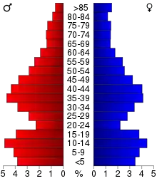
The county population contained 29.80% under the age of 18, 6.80% from 18 to 24, 29.90% from 25 to 44, 20.80% from 45 to 64, and 12.60% who were 65 years of age or older. The median age was 35 years. For every 100 females there were 105.00 males. For every 100 females age 18 and over, there were 104.00 males.
The median income for a household in the county was $39,852, and the median income for a family was $46,185. Males had a median income of $29,747 versus $23,630 for females. The per capita income for the county was $17,053. About 4.60% of families and 6.60% of the population were below the poverty line, including 6.50% of those under age 18 and 12.20% of those age 65 or over.
Government and politics
In presidential elections, Roseau is Minnesota's most reliably Republican-voting county. John McCain's and George W. Bush's best performances in Minnesota were in Roseau County. Bush won it twice, with over 65% of the vote. It was also one of the few Minnesota counties that George H. W. Bush won in 1992 and Bob Dole won in 1996.
Roseau County is less reliably Republican in senatorial and gubernatorial elections. The Democratic-Farmer-Labor Party has won two senatorial elections here since 1992. Independents do not perform as well in Roseau County as in the rest of Minnesota. In the 1998 gubernatorial election, Norm Coleman's best performance in Minnesota was in Roseau County, where he won with almost 50% of the vote.
| Election results from statewide races[15] | ||||
|---|---|---|---|---|
| Year | Office | GOP | DEM | Others |
| 2020 | President | 72.02% | 25.98% | 2% |
| Senator | 66.11% | 27.93% | 6% | |
| 2018 | Governor | 67.29% | 29.73% | 3% |
| Senator | 58.25% | 38.88% | 3% | |
| Senator | 64.08% | 32.40% | 3% | |
| 2016 | President | 69.8% | 23.8% | 6.3% |
| 2014 | Governor | 58.4% | 35.8% | 5.8% |
| Senator | 56.3% | 38.5% | 5.2% | |
| 2012 | President | 60.0% | 37.7% | 2.3% |
| Senator | 39.5% | 55.8% | 4.7% | |
| 2010 | Governor | 49.5% | 39.6% | 10.8% |
| 2008 | President | 57.6% | 40.2% | 2.2% |
| Senator | 57.5% | 31.7% | 10.8% | |
| 2006 | Governor | 56.2% | 38.8% | 5.0% |
| Senator | 46.7% | 49.4% | 3.9% | |
| 2004 | President | 67.7% | 30.9% | 1.4% |
| 2002 | Governor | 49.7% | 42.5% | 7.8% |
| Senator | 55.7% | 40.8% | 3.5% | |
| 2000 | President | 65.5% | 29.7% | 4.8% |
| Senator | 43.3% | 48.8% | 7.9% | |
| 1998 | Governor | 49.8% | 31.2% | 19.0% |
| 1996 | President | 43.2% | 39.9% | 16.9% |
| Senator | 54.6% | 40.9% | 4.5% | |
| 1994 | Governor | 59.8% | 37.6% | 2.6% |
| Senator | 59.1% | 36.6% | 4.3% | |
| 1992 | President | 38.3% | 32.2% | 29.5% |
| 1988 | President | 56.5% | 42.5% | 1.0% |
| 1984 | President | 59.3% | 39.9% | 0.8% |
| 1980 | President | 53.2% | 41.4% | 5.4% |
| 1976 | President | 41.4% | 55.9% | 2.7% |
| Year | Republican | Democratic | Third Parties |
|---|---|---|---|
| 2020 | 72.0% 6,065 | 26.0% 2,188 | 2.0% 168 |
| 2016 | 69.9% 5,451 | 23.8% 1,856 | 6.4% 497 |
| 2012 | 60.0% 4,409 | 37.7% 2,772 | 2.3% 171 |
| 2008 | 57.6% 4,438 | 40.2% 3,097 | 2.1% 165 |
| 2004 | 67.7% 5,355 | 30.9% 2,442 | 1.4% 114 |
| 2000 | 65.5% 4,695 | 29.7% 2,128 | 4.8% 343 |
| 1996 | 43.3% 2,988 | 39.9% 2,759 | 16.8% 1,162 |
| 1992 | 38.3% 2,785 | 32.3% 2,346 | 29.4% 2,138 |
| 1988 | 56.5% 3,500 | 42.5% 2,630 | 1.0% 62 |
| 1984 | 59.3% 3,445 | 39.9% 2,319 | 0.8% 47 |
| 1980 | 53.2% 3,358 | 41.4% 2,616 | 5.4% 343 |
| 1976 | 41.4% 2,382 | 55.9% 3,215 | 2.7% 155 |
| 1972 | 53.2% 2,844 | 44.8% 2,396 | 2.0% 104 |
| 1968 | 40.7% 2,048 | 52.6% 2,649 | 6.7% 338 |
| 1964 | 31.2% 1,651 | 68.7% 3,636 | 0.1% 6 |
| 1960 | 41.5% 2,274 | 58.3% 3,198 | 0.2% 10 |
| 1956 | 38.2% 1,901 | 61.6% 3,062 | 0.2% 10 |
| 1952 | 45.3% 2,596 | 53.5% 3,062 | 1.2% 69 |
| 1948 | 26.4% 1,458 | 66.5% 3,674 | 7.2% 396 |
| 1944 | 28.8% 1,513 | 70.4% 3,697 | 0.8% 40 |
| 1940 | 28.3% 1,730 | 70.1% 4,289 | 1.7% 104 |
| 1936 | 25.2% 1,326 | 71.4% 3,761 | 3.4% 179 |
| 1932 | 25.5% 1,078 | 66.4% 2,805 | 8.1% 341 |
| 1928 | 63.2% 2,618 | 32.4% 1,342 | 4.5% 185 |
| 1924 | 39.0% 1,300 | 4.4% 148 | 56.6% 1,886 |
| 1920 | 64.1% 2,387 | 13.4% 500 | 22.4% 835 |
| 1916 | 38.7% 821 | 39.3% 834 | 22.0% 466 |
| 1912 | 14.5% 278 | 15.6% 299 | 69.9% 1,341 |
| 1908 | 50.9% 900 | 25.1% 444 | 24.0% 424 |
| 1904 | 73.4% 1,042 | 12.8% 182 | 13.8% 196 |
| 1900 | 53.0% 632 | 45.1% 537 | 1.9% 23 |
| 1896 | 34.7% 287 | 63.7% 527 | 1.7% 14 |
| Position | Name | District | Next Election | |
|---|---|---|---|---|
| Commissioner | John Horner | District 1 | 2022 | |
| Commissioner | Jack Swanson | District 2 | 2020 | |
| Commissioner and Chairperson | Roger Falk | District 3 | 2020 | |
| Commissioner | Russell Walker | District 4 | 2020 | |
| Commissioner | Daryl Wicklund | District 5 | 2022 | |
| Position | Name | Affiliation | District | |
|---|---|---|---|---|
| Senate | Mark Johnson[17] | Republican | District 1 | |
| House of Representatives | Dan Fabian[18] | Republican | District 1A | |
| Position | Name | Affiliation | District | |
|---|---|---|---|---|
| House of Representatives | Collin Peterson[19] | Democrat | 7th | |
| Senate | Amy Klobuchar[20] | Democrat | N/A | |
| Senate | Tina Smith[21] | Democrat | N/A | |
Communities
Unincorporated communities
Townships
- Barnett Township
- Barto Township
- Beaver Township
- Cedarbend Township
- Deer Township
- Dewey Township
- Dieter Township
- Enstrom Township
- Falun Township
- Golden Valley Township
- Grimstad Township
- Hereim Township
- Huss Township
- Jadis Township
- Lake Township
- Laona Township
- Lind Township
- Malung Township
- Mickinock Township
- Moose Township
- Moranville Township
- Nereson Township
- Palmville Township
- Pohlitz Township
- Polonia Township
- Poplar Grove Township
- Reine Township
- Ross Township
- Skagen Township
- Soler Township
- Spruce Township
- Stafford Township
- Stokes Township
Unorganized territories
See also
- National Register of Historic Places listings in Roseau County, Minnesota
References
- "State & County QuickFacts". United States Census Bureau. Retrieved September 1, 2013.
- "Find a County". National Association of Counties. Retrieved June 7, 2011.
- Roseau History Archived September 25, 2006, at the Wayback Machine, Roseau MN. Accessed May 17, 2008.
- Historical Overview (accessed April 3, 2019)
- "Minnesota Place Names". Minnesota Historical Society. Archived from the original on June 20, 2012. Retrieved April 3, 2019.
- Upham, Warren (1920). Minnesota Geographic Names: Their Origin and Historic Significance. Minnesota Historical Society. p. 470.
- Nelson, Steven (2011). Savanna Soils of Minnesota. Minnesota: Self. pp. 57-60. ISBN 978-0-615-50320-2.
- Roseau County MN Google Maps (accessed 3 April 2019)
- "2010 Census Gazetteer Files". US Census Bureau. August 22, 2012. Archived from the original on September 21, 2013. Retrieved October 24, 2014.
- "Population and Housing Unit Estimates". Retrieved March 26, 2020.
- "US Decennial Census". US Census Bureau. Retrieved October 24, 2014.
- "Historical Census Browser". University of Virginia Library. Retrieved October 24, 2014.
- "Population of Counties by Decennial Census: 1900 to 1990". US Census Bureau. Retrieved October 24, 2014.
- "Census 2000 PHC-T-4. Ranking Tables for Counties: 1990 and 2000" (PDF). US Census Bureau. Retrieved October 24, 2014.
- Leip, David. "Atlas of US Presidential Elections". uselectionatlas.org. Retrieved October 10, 2018.
- "Board of Commissioners". www.co.roseau.mn.us. Retrieved June 25, 2020.
- "MN State Senate". www.senate.mn. Retrieved June 25, 2020.
- "Rep. Dan Fabian (01A) - Minnesota House of Representatives". www.house.leg.state.mn.us. Retrieved June 25, 2020.
- "Congressman Collin Peterson". Congressman Collin Peterson. Retrieved June 25, 2020.
- "U.S. Senator Amy Klobuchar". www.klobuchar.senate.gov. Retrieved June 24, 2020.
- "Home". Senator Tina Smith. Retrieved June 24, 2020.
External links
Places adjacent to Roseau County, Minnesota | |
|---|---|
Municipalities and communities of Roseau County, Minnesota, United States | ||
|---|---|---|
| Cities | Map of Minnesota highlighting Roseau County | |
| Townships | ||
| Unorganized territories | ||
| Unincorporated communities | ||
| Ghost town | ||
| Indian reservation | ||
| Footnotes | ‡This populated place also has portions in an adjacent county or counties | |
| ||

| Authority control |
|---|