Wilkin County, Minnesota
Wilkin County is a county in the U.S. state of Minnesota. As of the 2010 United States Census, the population of Wilkin County was 6,576.[1] Its county seat is Breckenridge.[2] The county is named for Colonel Alexander Wilkin, a lawyer who served as Minnesota's U.S. marshal and was later killed in the Civil War.
Wilkin County | |
|---|---|
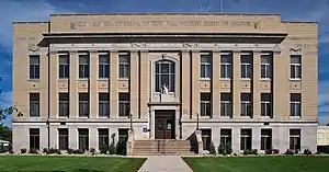 Wilkin County Courthouse in Breckenridge | |
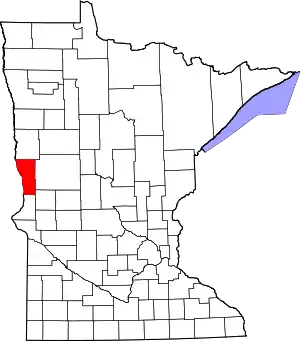 Location within the U.S. state of Minnesota | |
 Minnesota's location within the U.S. | |
| Coordinates: 46°22′N 96°28′W | |
| Country | |
| State | |
| Founded | March 8, 1858 (created as Toombs) 1863 (renamed) March 6, 1868 (renamed) |
| Named for | Alexander Wilkin |
| Seat | Breckenridge |
| Largest city | Breckenridge |
| Area | |
| • Total | 751 sq mi (1,950 km2) |
| • Land | 751 sq mi (1,950 km2) |
| • Water | 0.69 sq mi (1.8 km2) 0.03%% |
| Population (2010) | |
| • Total | 6,576 |
| • Estimate (2019) | 6,207 |
| • Density | 8.33/sq mi (3.22/km2) |
| Time zone | UTC−6 (Central) |
| • Summer (DST) | UTC−5 (CDT) |
| Congressional district | 7th |
| Website | www |
Wilkin County is part of the Wahpeton, ND–MN Micropolitan Statistical Area, which is included in the Fargo-Wahpeton, ND-MN Combined Statistical Area.
History
In 1849, the newly organized Minnesota Territory legislature authorized the creation of nine large counties across the territory. One of those, Pembina (later renamed as Kittson), contained areas that were partitioned off on 8 March 1858 to create Toombs County, named after Robert Toombs (1810–85) of Georgia. Toombs had been a member of the US House of Representatives (1845-1853), and US Senate (1853-1861). He became the Confederate secretary of state in 1861; this disloyalty to the Union displeased county residents, who petitioned for a name change. Accordingly, in 1863, the county was renamed Andy Johnson County for Andrew Johnson, who was serving as the military governor of Tennessee at the time. However, Johnson's actions and positions as US President (1865-1869) also displeased county residents, so on 6 March 1868 the county name was again changed, to Wilkin County. It was named for Colonel Alexander Wilkin, a Minnesota attorney and secretary to the Minnesota Territory governor.
The future Breckenridge, Minnesota was settled beginning in the 1850s, and a town was platted there in the spring of 1857. Thus when Toombs County was authorized in 1858, Breckenridge was listed as the county seat. It continued as the county seat through the subsequent county name changes.[3]
Geography
Wilkin County lies on the west side of Minnesota. Its west border abuts the east border of the state of North Dakota (across a river). The Bois de Sioux River flows northward along the county's west border. The Rabbit River flows westward through the lower part of the county and discharges into the Bois de Sioux on the county's lower west border. The Otter Tail River flows west-northwestward through the central part of the county and merges with the Bois de Sioux at Breckenridge to form the Red River, which continues to flow along the county's west line northward toward the Hudson Bay in Canada.
Wilkin County terrain consists of low rolling hills, completely devoted to agriculture.[5] The terrain slopes to the west and north, with its highest point on the upper east border at 1,250' (381m) ASL.[6] The county has a total area of 751 square miles (1,950 km2), of which 751 square miles (1,950 km2) is land and 0.2 square miles (0.52 km2) (0.03%) is water.[7]
Major highways
Adjacent counties
- Clay County - north
- Otter Tail County - east
- Grant County - southeast
- Traverse County - south
- Richland County, North Dakota - west
Protected areas[5]
- Akron State Wildlife Management Area
- Atherton State Wildlife Management Area
- Richard M. and Mathilde Rice Elliot Scientific and Natural Area
- Rothsay State Wildlife Management Area
- Sunnyside Township State Game Refuge
- Western Prairie Scientific and Natural Area
Lakes
- Breckenridge Lake - formed by a dam on the Otter Tail River in Breckenridge Township
Demographics
| Historical population | |||
|---|---|---|---|
| Census | Pop. | %± | |
| 1860 | 40 | — | |
| 1870 | 295 | 637.5% | |
| 1880 | 1,906 | 546.1% | |
| 1890 | 4,346 | 128.0% | |
| 1900 | 8,080 | 85.9% | |
| 1910 | 9,063 | 12.2% | |
| 1920 | 10,187 | 12.4% | |
| 1930 | 9,791 | −3.9% | |
| 1940 | 10,475 | 7.0% | |
| 1950 | 10,567 | 0.9% | |
| 1960 | 10,650 | 0.8% | |
| 1970 | 9,389 | −11.8% | |
| 1980 | 8,454 | −10.0% | |
| 1990 | 7,516 | −11.1% | |
| 2000 | 7,138 | −5.0% | |
| 2010 | 6,576 | −7.9% | |
| 2019 (est.) | 6,207 | [8] | −5.6% |
| US Decennial Census[9] 1790-1960[10] 1900-1990[11] 1990-2000[12] 2010-2019[1] | |||
2000 census
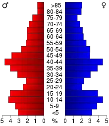
As of the 2000 United States Census, there were 7,138 people, 2,752 households, and 1,926 families in the county. The population density was 9.50/sqmi (3.67/km2). There were 3,105 housing units at an average density of 4.13/sqmi (1.60/km2). The racial makeup of the county was 97.77% White, 0.15% Black or African American, 0.42% Native American, 0.15% Asian, 0.01% Pacific Islander, 0.49% from other races, and 0.99% from two or more races. 1.54% of the population were Hispanic or Latino of any race. 41.8% were of German and 29.2% Norwegian ancestry.
There were 2,752 households, out of which 35.2% had children under the age of 18 living with them, 59.5% were married couples living together, 7.0% had a female householder with no husband present, and 30.0% were non-families. 25.9% of all households were made up of individuals, and 13.40% had someone living alone who was 65 years of age or older. The average household size was 2.54 and the average family size was 3.09.
The county population contained 27.8% under the age of 18, 7.0% from 18 to 24, 27.7% from 25 to 44, 21.5% from 45 to 64, and 16.1% who were 65 years of age or older. The median age was 38 years. For every 100 females there were 95.3 males. For every 100 females age 18 and over, there were 96.1 males.
The median income for a household in the county was $38,093, and the median income for a family was $46,220. Males had a median income of $31,273 versus $20,925 for females. The per capita income for the county was $16,873. About 6.2% of families and 8.1% of the population were below the poverty line, including 8.9% of those under age 18 and 8.3% of those age 65 or over.
2018 population estimates
The population estimate for Wilkin County in 2018 was 6,254. A five-year survey conducted between 2012 and 2016 found the median household income to be $52,963. The median housing value was $110,800 and there were 3,084 total housing units by 2016. As of 2016, 445 veterans resided in the county. 92.3% of county residents held a high-school diploma or higher. 8.9% of people were living in poverty at the end of 2016. 4.45 of people under the age of 65 had no health insurance. As of 2012, there were 709 companies in Wilkin County.[13]
Communities
Politics
Wilkin County voters have traditionally voted Republican. In no national election since 1976 has the county selected the Democratic Party candidate (as of 2016).
| Year | Republican | Democratic | Third parties |
|---|---|---|---|
| 2016 | 64.5% 2,129 | 27.0% 893 | 8.5% 280 |
| 2012 | 58.5% 1,884 | 39.0% 1,258 | 2.5% 80 |
| 2008 | 52.3% 1,786 | 45.4% 1,550 | 2.3% 78 |
| 2004 | 65.3% 2,303 | 33.1% 1,169 | 1.6% 55 |
| 2000 | 61.5% 2,032 | 31.7% 1,046 | 6.9% 227 |
| 1996 | 46.8% 1,508 | 41.0% 1,319 | 12.2% 393 |
| 1992 | 46.3% 1,626 | 32.0% 1,122 | 21.7% 762 |
| 1988 | 56.1% 1,933 | 43.1% 1,486 | 0.8% 28 |
| 1984 | 62.4% 2,367 | 37.1% 1,410 | 0.5% 19 |
| 1980 | 54.2% 2,224 | 36.4% 1,496 | 9.4% 387 |
| 1976 | 45.8% 1,882 | 51.2% 2,103 | 3.0% 125 |
| 1972 | 56.0% 2,292 | 42.5% 1,739 | 1.5% 62 |
| 1968 | 48.9% 2,037 | 46.7% 1,946 | 4.4% 182 |
| 1964 | 37.3% 1,636 | 62.7% 2,751 | 0.1% 4 |
| 1960 | 50.1% 2,340 | 49.7% 2,319 | 0.2% 8 |
| 1956 | 55.4% 2,335 | 44.6% 1,881 | 0.1% 2 |
| 1952 | 65.4% 2,979 | 34.3% 1,564 | 0.3% 13 |
| 1948 | 41.9% 1,700 | 56.4% 2,291 | 1.7% 69 |
| 1944 | 51.5% 1,945 | 48.2% 1,819 | 0.3% 12 |
| 1940 | 48.7% 2,067 | 51.2% 2,176 | 0.1% 6 |
| 1936 | 32.5% 1,278 | 61.7% 2,428 | 5.9% 232 |
| 1932 | 30.8% 1,126 | 67.9% 2,488 | 1.3% 48 |
| 1928 | 53.9% 1,874 | 45.4% 1,578 | 0.7% 25 |
| 1924 | 47.2% 1,342 | 8.6% 245 | 44.2% 1,258 |
| 1920 | 75.2% 2,106 | 20.0% 561 | 4.8% 134 |
| 1916 | 44.2% 690 | 51.8% 808 | 4.0% 63 |
| 1912 | 14.5% 209 | 40.6% 586 | 44.9% 649[15] |
| 1908 | 53.0% 779 | 41.8% 614 | 5.2% 76 |
| 1904 | 77.3% 1,103 | 17.2% 246 | 5.5% 78 |
| 1900 | 52.1% 812 | 42.5% 663 | 5.5% 85 |
| 1896 | 41.3% 631 | 56.0% 855 | 2.8% 42 |
| 1892 | 42.7% 434 | 35.7% 363 | 21.6% 220 |
| Position | Name | District | |
|---|---|---|---|
| Commissioner | Eric Klindt | District 1 | |
| Commissioner | Jonathan Green | District 2 | |
| Commissioner | Lyle Hovland | District 3 | |
| Commissioner and Vice Chair | Neil Folstad | District 4 | |
| Commissioner and Chairperson | Dennis Larson | District 5 | |
| Position | Name | Affiliation | District | |
|---|---|---|---|---|
| Senate | Torrey Westrom[17] | Republican | District 12 | |
| House of Representatives | Jeff Backer[18] | Republican | District 12A | |
| Position | Name | Affiliation | District | |
|---|---|---|---|---|
| House of Representatives | Collin Peterson[19] | Democrat | 7th | |
| Senate | Amy Klobuchar[20] | Democrat | N/A | |
| Senate | Tina Smith[21] | Democrat | N/A | |
See also
- National Register of Historic Places listings in Wilkin County, Minnesota
References
- "State & County QuickFacts". United States Census Bureau. Retrieved September 1, 2013.
- "Find a County". National Association of Counties. Retrieved June 7, 2011.
- Upham, Warren. Minnesota Geographic Names (1920), p. 577 (accessed April 21, 2019)
- Nelson, Steven (2011). Savanna Soils of Minnesota. Minnesota: Self. pp. 57 - 60. ISBN 978-0-615-50320-2.
- Wilkin County MN Google Maps (accessed 21 April 2019)
- "Find an Elevation/Wilkin County MN" Google Maps (accessed 21 April 2019)
- "2010 Census Gazetteer Files". US Census Bureau. August 22, 2012. Archived from the original on October 6, 2014. Retrieved October 25, 2014.
- "Population and Housing Unit Estimates". Retrieved March 26, 2020.
- "US Decennial Census". US Census Bureau. Retrieved October 25, 2014.
- "Historical Census Browser". University of Virginia Library. Retrieved October 25, 2014.
- "Population of Counties by Decennial Census: 1900 to 1990". US Census Bureau. Retrieved October 25, 2014.
- "Census 2000 PHC-T-4. Ranking Tables for Counties: 1990 and 2000" (PDF). US Census Bureau. Retrieved October 25, 2014.
- Bureau, US Census. "Search Results". www.census.gov. Retrieved October 22, 2018.
- Leip, David. "Atlas of US Presidential Elections". uselectionatlas.org. Retrieved October 10, 2018.
- The leading "other" candidate, Progressive Theodore Roosevelt, received 561 votes, while Socialist candidate Eugene Debs received 56 votes, Prohibition candidate Eugene Chafin received 30 votes, and Socialist Labor candidate Arthur Reimer received 2 votes.
- "County Board of Commissioners". www.co.wilkin.mn.us. Retrieved 2020-06-25.
- "MN State Senate". www.senate.mn. Retrieved 2020-06-24.
- "Rep. Jeff Backer (12A) - Minnesota House of Representatives". www.house.leg.state.mn.us. Retrieved 2020-06-24.
- "Congressman Collin Peterson". Congressman Collin Peterson. Retrieved 2020-06-24.
- "U.S. Senator Amy Klobuchar". www.klobuchar.senate.gov. Retrieved 2020-06-24.
- "Home". Senator Tina Smith. Retrieved 2020-06-24.
External links
Places adjacent to Wilkin County, Minnesota | ||||||||||
|---|---|---|---|---|---|---|---|---|---|---|
| ||||||||||
Municipalities and communities of Wilkin County, Minnesota, United States | ||
|---|---|---|
| Cities | Map of Minnesota highlighting Wilkin County | |
| Townships | ||
| Unincorporated communities | ||
| Footnotes | ‡This populated place also has portions in an adjacent county or counties | |
| ||

| Authority control |
|---|