Hubbard County, Minnesota
Hubbard County is a county in the northwestern part of the U.S. state of Minnesota. As of the 2010 United States Census, the population was 20,428.[2] Its county seat is Park Rapids.[3]
Hubbard County | |
|---|---|
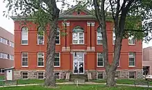 The historic Hubbard County Courthouse in Park Rapids | |
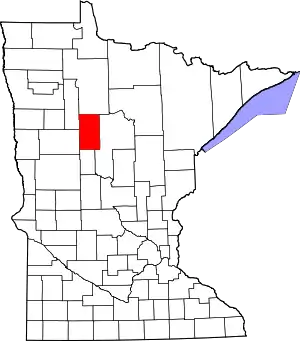 Location within the U.S. state of Minnesota | |
 Minnesota's location within the U.S. | |
| Coordinates: 47°06′N 94°55′W | |
| Country | |
| State | |
| Founded | February 26, 1883[1] |
| Named for | Lucius Frederick Hubbard |
| Seat | Park Rapids |
| Largest city | Park Rapids |
| Area | |
| • Total | 999.39 sq mi (2,588.4 km2) |
| • Land | 922.46 sq mi (2,389.2 km2) |
| • Water | 76.93 sq mi (199.2 km2) 7.70%% |
| Population (2010) | |
| • Total | 20,428 |
| • Estimate (2019) | 21,491 |
| • Density | 22.8/sq mi (8/km2) |
| Time zone | UTC−6 (Central) |
| • Summer (DST) | UTC−5 (CDT) |
| Congressional district | 8th |
| Website | www |
Part of the Leech Lake Indian Reservation is in the county.
History
The county was created on February 26, 1883, with territory partitioned from Cass County. It was named for Lucius Frederick Hubbard, a prominent Territory editor, Civil War participant, and businessman who was governor of Minnesota from 1882 to 1887.[4][5] The county's boundaries have remained unchanged since its creation.
The new county's courthouse was destroyed by fire around 1890, but the public records were salvaged.
Geography
The county's terrain is hilly, largely wooded, and dotted with lakes and ponds.[6] It generally slopes to the east, with the northern part sloping to the north and the southern part sloping to the south. Its highest point is near the lower middle of its western border, at 1,549' (472m) ASL.[7] The county has an area of 1,000 square miles (2,600 km2), of which 926 square miles (2,400 km2) is land and 74 square miles (190 km2) (7.4%) is water.[8]
Major highways
Adjacent counties
- Beltrami County - north
- Cass County - east
- Wadena County - south
- Becker County - southwest
- Clearwater County - northwest
Protected areas[6]
- Badoura Jack Pine Woodland Scientific and Natural Area
- Huntersville State Forest (part)
- Itasca State Park (part)
- Mississippi Headwaters (part)
- Paul Bunyan State Forest (part)
Demographics
| Historical population | |||
|---|---|---|---|
| Census | Pop. | %± | |
| 1890 | 1,412 | — | |
| 1900 | 6,578 | 365.9% | |
| 1910 | 9,831 | 49.5% | |
| 1920 | 10,136 | 3.1% | |
| 1930 | 9,596 | −5.3% | |
| 1940 | 11,085 | 15.5% | |
| 1950 | 11,085 | 0.0% | |
| 1960 | 9,962 | −10.1% | |
| 1970 | 10,583 | 6.2% | |
| 1980 | 14,098 | 33.2% | |
| 1990 | 14,939 | 6.0% | |
| 2000 | 18,376 | 23.0% | |
| 2010 | 20,428 | 11.2% | |
| 2019 (est.) | 21,491 | [10] | 5.2% |
| US Decennial Census[11] 1790-1960[12] 1900-1990[13] 1990-2000[14] 2010-2019[2] | |||
2000 census
As of the 2000 United States Census,[15] there were 18,376 people, 7,435 households, and 5,345 families in the county. The population density was 19.9/sqmi (7.69/km2). There were 12,229 housing units at an average density of 13.3/sqmi (5.12/km2). The racial makeup of the county was 96.31% White, 0.17% Black or African American, 2.13% Native American, 0.27% Asian, 0.01% Pacific Islander, 0.22% from other races, and 0.89% from two or more races. 0.67% of the population were Hispanic or Latino of any race. 35.0% were of German, 20.5% Norwegian, 6.0% English and 5.8% Swedish ancestry.
There were 7,435 households, out of which 29.30% had children under the age of 18 living with them, 61.10% were married couples living together, 7.10% had a female householder with no husband present, and 28.10% were non-families. 24.20% of all households were made up of individuals, and 11.30% had someone living alone who was 65 years of age or older. The average household size was 2.45 and the average family size was 2.88.
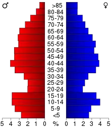
The county population contained 24.60% under the age of 18, 6.40% from 18 to 24, 24.10% from 25 to 44, 26.90% from 45 to 64, and 18.00% who were 65 years of age or older. The median age was 42 years. For every 100 females there were 99.90 males. For every 100 females age 18 and over, there were 98.00 males.
The median income for a household in the county was $35,321, and the median income for a family was $41,177. Males had a median income of $30,030 versus $21,616 for females. The per capita income for the county was $18,115. 9.70% of the population and 7.50% of families were below the poverty line. 12.50% of those under the age of 18 and 9.30% of those 65 and older were living below the poverty line.
Communities
Cities
Census-designated place
Townships
- Akeley Township
- Arago Township
- Badoura Township
- Clay Township
- Clover Township
- Crow Wing Lake Township
- Farden Township
- Fern Township
- Guthrie Township
- Hart Lake Township
- Helga Township
- Hendrickson Township
- Henrietta Township
- Hubbard Township
- Lake Alice Township
- Lake Emma Township
- Lake George Township
- Lake Hattie Township
- Lakeport Township
- Mantrap Township
- Nevis Township
- Rockwood Township
- Schoolcraft Township
- Steamboat River Township
- Straight River Township
- Thorpe Township
- Todd Township
- White Oak Township
Government and politics
Hubbard County voters have leaned toward the Republican Party for several decades. As of 2016 the county has selected the Republican candidate in 78% of presidential elections since 1980.
| Year | Republican | Democratic | Third parties |
|---|---|---|---|
| 2020 | 63.3% 8,202 | 34.4% 4,462 | 2.3% 301 |
| 2016 | 63.1% 7,261 | 29.8% 3,423 | 7.1% 821 |
| 2012 | 57.5% 6,622 | 40.6% 4,676 | 1.9% 222 |
| 2008 | 56.4% 6,558 | 41.9% 4,872 | 1.8% 208 |
| 2004 | 56.8% 6,444 | 41.8% 4,741 | 1.4% 155 |
| 2000 | 55.2% 5,307 | 37.8% 3,632 | 7.0% 674 |
| 1996 | 41.3% 3,593 | 43.7% 3,802 | 15.1% 1,316 |
| 1992 | 37.6% 3,227 | 39.1% 3,362 | 23.3% 2,000 |
| 1988 | 56.4% 4,365 | 42.7% 3,306 | 0.8% 65 |
| 1984 | 61.8% 4,621 | 37.5% 2,806 | 0.7% 55 |
| 1980 | 55.5% 4,172 | 37.8% 2,840 | 6.7% 501 |
| 1976 | 46.0% 2,985 | 49.3% 3,196 | 4.8% 308 |
| 1972 | 59.3% 3,294 | 38.5% 2,136 | 2.2% 124 |
| 1968 | 55.0% 2,720 | 38.8% 1,920 | 6.3% 310 |
| 1964 | 47.1% 2,283 | 52.7% 2,553 | 0.1% 7 |
| 1960 | 57.4% 2,749 | 42.4% 2,029 | 0.2% 9 |
| 1956 | 62.7% 2,453 | 37.2% 1,454 | 0.2% 6 |
| 1952 | 69.0% 3,099 | 30.3% 1,360 | 0.8% 34 |
| 1948 | 48.8% 2,071 | 48.2% 2,044 | 3.0% 126 |
| 1944 | 56.5% 2,114 | 43.1% 1,613 | 0.4% 13 |
| 1940 | 54.0% 2,544 | 45.5% 2,141 | 0.6% 26 |
| 1936 | 39.8% 1,618 | 56.9% 2,312 | 3.3% 132 |
| 1932 | 36.0% 1,349 | 59.5% 2,230 | 4.6% 172 |
| 1928 | 65.8% 2,291 | 32.2% 1,120 | 2.1% 73 |
| 1924 | 57.8% 1,884 | 5.9% 191 | 36.3% 1,184 |
| 1920 | 73.8% 2,238 | 15.0% 453 | 11.2% 340 |
| 1916 | 40.4% 685 | 47.1% 799 | 12.5% 212 |
| 1912 | 21.2% 359 | 26.6% 450 | 52.2% 884 |
| 1908 | 69.1% 1,288 | 21.5% 401 | 9.4% 175 |
| 1904 | 80.0% 1,392 | 13.3% 232 | 6.7% 117 |
| 1900 | 66.1% 1,009 | 30.4% 464 | 3.5% 53 |
| 1896 | 49.7% 364 | 47.0% 344 | 3.3% 24 |
| 1892 | 35.7% 164 | 28.0% 129 | 36.3% 167 |
| Position | Name | District | |
|---|---|---|---|
| Commissioner | David De La Hunt | District 1 | |
| Commissioner and Chairperson | Charlene Christenson | District 2 | |
| Commissioner | Tom Krueger | District 3 | |
| Commissioner | Daniel Stacy | District 4 | |
| Commissioner | Ted Van Kempen | District 5 | |
| Position | Name | Affiliation | District | |
|---|---|---|---|---|
| Senate | Paul Utke[18] | Republican | District 2 | |
| House of Representatives | Matt Grossell[19] | Republican | District 2A | |
| House of Representatives | Steve Green[20] | Republican | District 2B | |
| Position | Name | Affiliation | District | |
|---|---|---|---|---|
| House of Representatives | Pete Stauber[21] | Republican | 8th | |
| Senate | Amy Klobuchar[22] | Democrat | N/A | |
| Senate | Tina Smith[23] | Democrat | N/A | |
References
- "Minnesota Place Names". Minnesota Historical Society. Archived from the original on June 20, 2012. Retrieved March 18, 2014.
- "State & County QuickFacts". United States Census Bureau. Archived from the original on June 7, 2011. Retrieved September 1, 2013.
- "Find a County". National Association of Counties. Archived from the original on May 31, 2011. Retrieved June 7, 2011.
- Upham, Warren. Minnesota Geographic Names, p. 242 (1920). Accessed 12 March 2019
- Gannett, Henry (1905). The Origin of Certain Place Names in the United States. Govt. Print. Off. p. 162.
- Hubbard County MN Google Maps (accessed 12 March 2019)
- ""Find an Altitude/Hubbard County MN" Google Maps (accessed 12 March 2019)". Archived from the original on May 21, 2019. Retrieved March 12, 2019.
- "2010 Census Gazetteer Files". US Census Bureau. August 22, 2012. Archived from the original on October 6, 2014. Retrieved October 15, 2014.
- Nelson, Steven (2011). Savanna Soils of Minnesota. Minnesota: Self. pp. 53-56. ISBN 978-0-615-50320-2.
- "Population and Housing Unit Estimates". Retrieved March 26, 2020.
- "US Decennial Census". US Census Bureau. Retrieved October 15, 2014.
- "Historical Census Browser". University of Virginia Library. Retrieved October 15, 2014.
- "Population of Counties by Decennial Census: 1900 to 1990". US Census Bureau. Retrieved October 15, 2014.
- "Census 2000 PHC-T-4. Ranking Tables for Counties: 1990 and 2000" (PDF). US Census Bureau. Retrieved October 15, 2014.
- "U.S. Census website". U.S. Census Bureau. Retrieved January 31, 2008.
- Leip, David. "Atlas of US Presidential Elections". uselectionatlas.org. Retrieved September 19, 2018.
- "Board of Commissioners". www.co.hubbard.mn.us. Retrieved June 25, 2020.
- "MN State Senate". www.senate.mn. Retrieved June 25, 2020.
- "Rep. Matt Grossell (02A) - Minnesota House of Representatives". www.house.leg.state.mn.us. Retrieved June 25, 2020.
- "Rep. Steve Green (02B) - Minnesota House of Representatives". www.house.leg.state.mn.us. Retrieved June 25, 2020.
- "Representative Pete Stauber". Representative Pete Stauber. Retrieved June 24, 2020.
- "U.S. Senator Amy Klobuchar". www.klobuchar.senate.gov. Retrieved June 24, 2020.
- "Home". Senator Tina Smith. Retrieved June 24, 2020.
External links
- Hubbard County government’s website
- Hubbard County Historical Society
- Hubbard County Genealogical Society
Places adjacent to Hubbard County, Minnesota | ||||||||||
|---|---|---|---|---|---|---|---|---|---|---|
| ||||||||||
Municipalities and communities of Hubbard County, Minnesota, United States | ||
|---|---|---|
| Cities | Map of Minnesota highlighting Hubbard County | |
| Townships | ||
| CDP | ||
| Unincorporated communities | ||
| Indian reservation | ||
| Footnotes | ‡This populated place also has portions in an adjacent county or counties | |
| ||

| Authority control |
|---|