Douglas County, Minnesota
Douglas County is a county in the U.S. state of Minnesota. As of the 2010 United States Census, the population was 36,009.[2] Its county seat is Alexandria.[3]
Douglas County | |
|---|---|
.jpg.webp) Douglas County Courthouse in Alexandria, Minnesota. | |
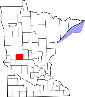 Location within the U.S. state of Minnesota | |
 Minnesota's location within the U.S. | |
| Coordinates: 45°56′N 95°27′W | |
| Country | |
| State | |
| Founded | March 8, 1858 (created) 1866 (organized)[1] |
| Named for | Stephen A. Douglas |
| Seat | Alexandria |
| Largest city | Alexandria |
| Area | |
| • Total | 720 sq mi (1,900 km2) |
| • Land | 637 sq mi (1,650 km2) |
| • Water | 83 sq mi (210 km2) 11%% |
| Population (2010) | |
| • Total | 36,009 |
| • Estimate (2019) | 38,141 |
| • Density | 59.0/sq mi (22.8/km2) |
| Time zone | UTC−6 (Central) |
| • Summer (DST) | UTC−5 (CDT) |
| Congressional district | 7th |
| Website | www |
Douglas County comprises the Alexandria, Minnesota, Micropolitan Statistical Area.
Douglas County is the home of Minnesota's only wine-grape appellation, the 10,880 acres (44.0 km2) Alexandria Lakes AVA.[4]
History
The territorial legislature created Douglas County on March 8, 1858, shortly before Minnesota attained statehood. It was named for political figure Stephen A. Douglas, who was serving as a US Senator from Illinois at the time of the county's creation.[5] The county organization was completed in 1866.
Geography
Spruce Creek flows southeast through northeastern Douglas county. The county consists of rolling hills, heavily dotted with lakes and ponds, especially in its north-to-south central portion.[6] The hilly terrain generally slopes to the south and west; its highest point is near the northeast corner, at 1,483' (452m) ASL.[7] The county has an area of 720 square miles (1,900 km2), of which 637 square miles (1,650 km2) is land and 83 square miles (210 km2) (11%) is water.[8] It contains more than 250 lakes.
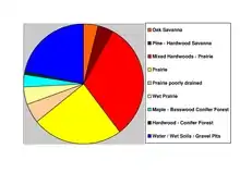
The county includes two of Minnesota's biomes: prairie grassland in the west and southeast, savannas (also prairie ecosystems) in the middle, and temperate deciduous forest in the south-central, north, and east.[9] Douglas is one of 17 Minnesota counties where savanna soils predominate.
Major highways
Airports
- Alexandria Municipal Airport ("Chandler Field"), city-owned public-use airport
Adjacent counties
- Otter Tail County - north
- Todd County - east
- Stearns County - southeast
- Pope County - south
- Stevens County - southwest
- Grant County - west
Protected areas[6]
- Anderson State Wildlife Management Area
- Balgaard State Wildlife Management Area
- Chermak State Wildlife Management Area
- Herberger Lake State Wildlife Management Area
- Kensington State Wildlife Management Area
- La Grand State Wildlife Management Area
- Lake Carlos State Park
- Osakis State Wildlife Management Area North Unit (part)
- Red Rock Wildlife Management Area
- Roger M. Holmes State Wildlife Management Area
- Schnepf State Wildlife Management Area
- Thornberg State Wildlife Management Area
- Urness State Wildlife Management Area
Demographics
| Historical population | |||
|---|---|---|---|
| Census | Pop. | %± | |
| 1870 | 4,239 | — | |
| 1880 | 9,130 | 115.4% | |
| 1890 | 14,606 | 60.0% | |
| 1900 | 17,964 | 23.0% | |
| 1910 | 17,669 | −1.6% | |
| 1920 | 19,039 | 7.8% | |
| 1930 | 18,813 | −1.2% | |
| 1940 | 20,369 | 8.3% | |
| 1950 | 21,304 | 4.6% | |
| 1960 | 21,313 | 0.0% | |
| 1970 | 22,892 | 7.4% | |
| 1980 | 27,839 | 21.6% | |
| 1990 | 28,839 | 3.6% | |
| 2000 | 32,821 | 13.8% | |
| 2010 | 36,009 | 9.7% | |
| 2019 (est.) | 38,141 | [11] | 5.9% |
| US Decennial Census[12] 1790-1960[13] 1900-1990[14] 1990-2000[15] 2010-2019[2] | |||

2000 census
As of the 2000 United States Census,[16] there were 32,821 people, 13,276 households, and 9,027 families in the county. The population density was 51.5/sqmi (19.9/km2). There were 16,694 housing units at an average density of 26.2/sqmi (10.1/km2). The racial makeup of the county was 98.49% White, 0.18% Black or African American, 0.24% Native American, 0.40% Asian, 0.03% Pacific Islander, 0.18% from other races, and 0.48% from two or more races. 0.59% of the population were Hispanic or Latino of any race. 38.5% were of German, 24.6% Norwegian and 8.1% Swedish ancestry.
There were 13,276 households, out of which 29.90% had children under the age of 18 living with them, 59.00% were married couples living together, 6.40% had a female householder with no husband present, and 32.00% were non-families. 26.50% of all households were made up of individuals, and 12.30% had someone living alone who was 65 years of age or older. The average household size was 2.42 and the average family size was 2.93.
The county population contained 24.00% under the age of 18, 9.20% from 18 to 24, 25.00% from 25 to 44, 23.80% from 45 to 64, and 17.90% who were 65 years of age or older. The median age was 40 years. For every 100 females there were 99.00 males. For every 100 females age 18 and over, there were 96.90 males.
The median income for a household in the county was $37,703, and the median income for a family was $46,250. Males had a median income of $30,968 versus $21,240 for females. The per capita income for the county was $18,850. About 5.60% of families and 8.50% of the population were below the poverty line, including 9.30% of those under age 18 and 11.00% of those age 65 or over.
Communities
Cities
- Alexandria (county seat)
- Brandon
- Carlos
- Evansville
- Forada
- Garfield
- Kensington
- Millerville
- Miltona
- Nelson
- Osakis (part)
Unincorporated communities[6]
- Belle River
- Holmes City
- Leaf Valley
- Rose City
Townships
- Alexandria Township
- Belle River Township
- Brandon Township
- Carlos Township
- Evansville Township
- Holmes City Township
- Hudson Township
- Ida Township
- La Grand Township
- Lake Mary Township
- Leaf Valley Township
- Lund Township
- Millerville Township
- Miltona Township
- Moe Township
- Orange Township
- Osakis Township
- Solem Township
- Spruce Hill Township
- Urness Township
Government and politics
Douglas County traditionally votes Republican. In only one presidential election since 1964 has it selected the Democratic candidate.
| Year | Republican | Democratic | Third parties |
|---|---|---|---|
| 2016 | 64.1% 13,966 | 28.6% 6,227 | 7.3% 1,592 |
| 2012 | 56.7% 11,884 | 41.3% 8,653 | 2.0% 416 |
| 2008 | 53.7% 11,241 | 44.3% 9,256 | 2.0% 421 |
| 2004 | 58.1% 11,793 | 40.5% 8,219 | 1.5% 297 |
| 2000 | 57.0% 9,811 | 36.9% 6,352 | 6.1% 1,042 |
| 1996 | 43.6% 6,747 | 41.7% 6,450 | 14.7% 2,267 |
| 1992 | 40.1% 6,356 | 33.1% 5,252 | 26.8% 4,251 |
| 1988 | 57.0% 7,898 | 41.9% 5,803 | 1.1% 151 |
| 1984 | 61.9% 9,005 | 37.4% 5,444 | 0.7% 94 |
| 1980 | 53.9% 7,778 | 38.3% 5,530 | 7.9% 1,137 |
| 1976 | 44.4% 5,910 | 53.3% 7,097 | 2.3% 307 |
| 1972 | 53.0% 6,678 | 43.6% 5,501 | 3.4% 427 |
| 1968 | 50.4% 5,464 | 44.5% 4,826 | 5.1% 549 |
| 1964 | 40.5% 4,122 | 59.4% 6,040 | 0.1% 13 |
| 1960 | 53.3% 5,594 | 46.4% 4,871 | 0.4% 41 |
| 1956 | 54.9% 5,114 | 45.0% 4,194 | 0.1% 12 |
| 1952 | 61.3% 6,037 | 38.3% 3,768 | 0.4% 43 |
| 1948 | 41.7% 3,744 | 56.0% 5,022 | 2.3% 207 |
| 1944 | 52.6% 4,140 | 46.8% 3,681 | 0.6% 46 |
| 1940 | 50.5% 4,652 | 49.0% 4,507 | 0.5% 48 |
| 1936 | 36.4% 2,681 | 56.8% 4,186 | 6.8% 497 |
| 1932 | 30.4% 2,325 | 66.6% 5,101 | 3.0% 230 |
| 1928 | 59.3% 4,262 | 39.3% 2,829 | 1.4% 100 |
| 1924 | 39.2% 2,424 | 5.1% 315 | 55.8% 3,453 |
| 1920 | 66.1% 4,428 | 11.0% 733 | 22.9% 1,535 |
| 1916 | 50.3% 1,709 | 41.1% 1,398 | 8.6% 293 |
| 1912 | 14.9% 435 | 27.2% 793 | 57.8% 1,684 |
| 1908 | 60.9% 1,894 | 31.5% 979 | 7.6% 236 |
| 1904 | 79.4% 2,171 | 15.0% 410 | 5.6% 153 |
| 1900 | 59.9% 1,917 | 37.3% 1,194 | 2.8% 91 |
| 1896 | 57.8% 1,966 | 39.7% 1,350 | 2.4% 83 |
| 1892 | 50.9% 1,315 | 20.6% 533 | 28.5% 736 |
| Position | Name | District | |
|---|---|---|---|
| Commissioner | Keith Englund | District 1 | |
| Commissioner | Tim Kalina | District 2 | |
| Commissioner | Jerry Rapp | District 3 | |
| Commissioner | Charlie Meyer | District 4 | |
| Commissioner | Heather Larson | District 5 | |
| Position | Name | Affiliation | District | |
|---|---|---|---|---|
| Senate | Bill Ingebrigtsen[19] | Republican | District 8 | |
| Senate | Torrey Westrom[20] | Republican | District 12 | |
| House of Representatives | Mary Franson[21] | Republican | District 8B | |
| House of Representatives | Jeff Backer[22] | Republican | District 12A | |
| House of Representatives | Paul Anderson[23] | Republican | District 12B | |
| Position | Name | Affiliation | District | |
|---|---|---|---|---|
| House of Representatives | Collin Peterson[24] | Democrat | 7th | |
| Senate | Amy Klobuchar[25] | Democrat | N/A | |
| Senate | Tina Smith[26] | Democrat | N/A | |
References
- "Minnesota Place Names". Minnesota Historical Society. Archived from the original on June 20, 2012. Retrieved March 18, 2014.
- "State & County QuickFacts". United States Census Bureau. Archived from the original on June 7, 2011. Retrieved August 31, 2013.
- "Find a County". National Association of Counties. Archived from the original on May 31, 2011. Retrieved June 7, 2011.
- (PDF). April 22, 2006 https://web.archive.org/web/20060422035826/http://a257.g.akamaitech.net/7/257/2422/01jan20051800/edocket.access.gpo.gov/2005/pdf/05-13040.pdf. Archived from the original (PDF) on April 22, 2006. Missing or empty
|title=(help) - Gannett, Henry (1905). The Origin of Certain Place Names in the United States. Govt. Print. Off. p. 108.
- Douglas County MN Google Maps (accessed March 7, 2019)
- "Find an Altitude/Douglas County MN" Google Maps (accessed March 7, 2019)
- "2010 Census Gazetteer Files". US Census Bureau. August 22, 2012. Archived from the original on October 6, 2014. Retrieved October 15, 2014.
- "Minnesota's Biomes" (PDF). Minnesota Department of Natural Resources. 2008. Retrieved February 27, 2010.
- Nelson, Steven (2011). Savanna Soils of Minnesota. Minnesota: Self. pp. 53-56. ISBN 978-0-615-50320-2.
- "Population and Housing Unit Estimates". Retrieved March 26, 2020.
- "US Decennial Census". US Census Bureau. Retrieved October 15, 2014.
- "Historical Census Browser". University of Virginia Library. Retrieved October 15, 2014.
- "Population of Counties by Decennial Census: 1900 to 1990". US Census Bureau. Retrieved October 15, 2014.
- "Census 2000 PHC-T-4. Ranking Tables for Counties: 1990 and 2000" (PDF). US Census Bureau. Retrieved October 15, 2014.
- "U.S. Census website". US Census Bureau. Retrieved January 31, 2008.
- Leip, David. "Atlas of US Presidential Elections". uselectionatlas.org.
- "Douglas County | Members". www.co.douglas.mn.us. Retrieved June 26, 2020.
- "MN State Senate". www.senate.mn. Retrieved June 26, 2020.
- "MN State Senate". www.senate.mn. Retrieved June 24, 2020.
- "Rep. Mary Franson (08B) - Minnesota House of Representatives". www.house.leg.state.mn.us. Retrieved June 26, 2020.
- "Rep. Jeff Backer (12A) - Minnesota House of Representatives". www.house.leg.state.mn.us. Retrieved June 24, 2020.
- "Rep. Paul Anderson (12B) - Minnesota House of Representatives". www.house.leg.state.mn.us. Retrieved June 26, 2020.
- "Congressman Collin Peterson". Congressman Collin Peterson. Retrieved June 24, 2020.
- "U.S. Senator Amy Klobuchar". www.klobuchar.senate.gov. Retrieved June 24, 2020.
- "Home". Senator Tina Smith. Retrieved June 24, 2020.
External links
- Douglas County website
- Alexandria Area Economic Development Commission website
- Douglas County MN Area Manufacturing & Healthcare Opportunities
Places adjacent to Douglas County, Minnesota | ||||||||||
|---|---|---|---|---|---|---|---|---|---|---|
| ||||||||||
Municipalities and communities of Douglas County, Minnesota, United States | ||
|---|---|---|
| Cities | Map of Minnesota highlighting Douglas County | |
| Townships | ||
| Unincorporated communities | ||
| Footnotes | ‡This populated place also has portions in an adjacent county or counties | |
| ||

| Authority control |
|---|