Lincoln County, Minnesota
Lincoln County is a county in the U.S. state of Minnesota. As of the 2010 United States Census, the population was 5,896.[3] Its county seat is Ivanhoe.[4]
Lincoln County | |
|---|---|
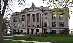 Lincoln County Courthouse | |
 Location within the U.S. state of Minnesota | |
 Minnesota's location within the U.S. | |
| Coordinates: 44°25′N 96°16′W | |
| Country | |
| State | |
| Founded | March 6, 1873[1] |
| Named for | Abraham Lincoln[2] |
| Seat | Ivanhoe |
| Largest city | Tyler |
| Area | |
| • Total | 548 sq mi (1,420 km2) |
| • Land | 537 sq mi (1,390 km2) |
| • Water | 12 sq mi (30 km2) 2.1%% |
| Population (2010) | |
| • Total | 5,896 |
| • Estimate (2019) | 5,639 |
| • Density | 10.6/sq mi (4.1/km2) |
| Time zone | UTC−6 (Central) |
| • Summer (DST) | UTC−5 (CDT) |
| Congressional district | 7th |
| Website | www |
History
During and after the American Civil War, the Minnesota legislature wanted to name a county after President Abraham Lincoln. Acts were proposed to effect this change in 1861, in 1866, and in 1870, but each time the effort failed by vote or was ignored by the county's citizens. The final effort was an act passed on March 6, 1873, dividing Lyon County into approximately equal halves, with the western half to be named Lincoln. The county voters approved this act in the November 1873 election, and Governor Horace Austin proclaimed the county's existence on December 5, 1873, with Lake Benton as county seat. In 1900 a new town closer to the county's center was platted, and in 1902 the county seat was moved to that settlement, Ivanhoe.[5]
Geography
Lincoln County lies on Minnesota's border with South Dakota. The Lac qui Parle River flows northeast through the upper eastern part of the county on its way to discharge into the Minnesota River. The county's terrain consists of rolling hills and is mostly devoted to agriculture.[6] The terrain slopes to the north and east, with its highest point on its lower west border, at 1,991' (607m) ASL.[7] The county has an area of 548 square miles (1,420 km2), of which 537 square miles (1,390 km2) is land and 12 square miles (31 km2) (2.1%) is water.[8]
Lakes[6]
- Ash Lake
- Curtis Lake
- Dead Coon Lake
- Drietz Lake
- Gislason Lake
- Hawks Nest Lake
- Lake Benton
- Lake Hendricks (part)
- Lake Shaokatan
- Lake Stay
- Oak Lake
- Perch Lake
- Steep Bank Lake
- Twin Lakes
- West Lake Stay
Major highways
Adjacent counties[7]
- Deuel County, South Dakota - northwest
- Yellow Medicine County - north
- Lyon County - east
- Pipestone County - south
- Moody County, South Dakota - southwest
- Brookings County, South Dakota - west
Protected areas[6]
- Altona State Wildlife Management Area (part)
- Ash Lake State Wildlife Management Area
- Blue Wing State Wildlife Management Area
- Bohemian State Wildlife Management Area (part)
- Chen-Bay State Wildlife Management Area
- Christine State Wildlife Management Area
- Collinson State Wildlife Management Area
- Dorer State Wildlife Management Area
- Emerald State Wildlife Management Area
- Expectation State Wildlife Management Area
- Hendricks State Wildlife Management Area
- Hole in the Mountain County Park
- Hope State Wildlife Management Area (part)
- Iron Horse State Wildlife Management Area
- Ivanhoe State Wildlife Management Area
- Johnson State Wildlife Management Area
- Kvermo State Wildlife Management Area
- Minn-Kota State Wildlife Management Area
- Northern Tallgrass Prairie National Wildlife Refuge
- Platyrhynchos State Wildlife Management Area
- Poposki State Wildlife Management Area
- Prairie Dell State Wildlife Management Area
- Shaokatan State Wildlife Management Area
- Sioux Lookout State Wildlife Management Area
- Sokota State Wildlife Management Area (part)
- Suhr State Wildlife Management Area
- Two Sloughs State Wildlife Management Area
Demographics
| Historical population | |||
|---|---|---|---|
| Census | Pop. | %± | |
| 1880 | 2,945 | — | |
| 1890 | 5,691 | 93.2% | |
| 1900 | 8,966 | 57.5% | |
| 1910 | 9,874 | 10.1% | |
| 1920 | 11,268 | 14.1% | |
| 1930 | 11,303 | 0.3% | |
| 1940 | 10,797 | −4.5% | |
| 1950 | 10,150 | −6.0% | |
| 1960 | 9,651 | −4.9% | |
| 1970 | 8,143 | −15.6% | |
| 1980 | 8,207 | 0.8% | |
| 1990 | 6,890 | −16.0% | |
| 2000 | 6,429 | −6.7% | |
| 2010 | 5,896 | −8.3% | |
| 2019 (est.) | 5,639 | [10] | −4.4% |
| US Decennial Census[11] 1790-1960[12] 1900-1990[13] 1990-2000[14] 2010-2019[3] | |||
2000 census
As of the 2000 United States Census,[15] there were 6,429 people, 2,653 households, and 1,785 families in the county. The population density was 12.0/sqmi (4.62/km2). There were 3,043 housing units at an average density of 5.67/sqmi (2.19/km2). The racial makeup of the county was 98.82% White, 0.05% Black or African American, 0.28% Native American, 0.20% Asian, 0.42% from other races, and 0.23% from two or more races. 0.86% of the population were Hispanic or Latino of any race. 36.1% were of German, 25% English, 17.5% Norwegian, 10.9% Polish and 10.5% Danish ancestry.
There were 2,653 households, out of which 27.00% had children under the age of 18 living with them, 59.70% were married couples living together, 4.60% had a female householder with no husband present, and 32.70% were non-families. 30.50% of all households were made up of individuals, and 16.80% had someone living alone who was 65 years of age or older. The average household size was 2.35 and the average family size was 2.93.
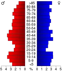
The county population contained 23.70% under the age of 18, 6.10% from 18 to 24, 23.00% from 25 to 44, 22.70% from 45 to 64, and 24.50% who were 65 years of age or older. The median age was 43 years. For every 100 females there were 97.30 males. For every 100 females age 18 and over, there were 94.80 males.
The median income for a household in the county was $31,607, and the median income for a family was $38,605. Males had a median income of $26,494 versus $20,083 for females. The per capita income for the county was $16,009. About 7.00% of families and 9.70% of the population were below the poverty line, including 9.60% of those under age 18 and 15.00% of those age 65 or over.
Communities
Cities
- Arco
- Hendricks
- Ivanhoe (county seat)
- Lake Benton
- Tyler
Government and politics
Lincoln County has been a swing district in recent decades. As of 2016 it has selected the Democratic candidate in 56% of presidential elections since 1980.
| Year | Republican | Democratic | Third parties |
|---|---|---|---|
| 2016 | 64.0% 1,931 | 28.5% 860 | 7.6% 228 |
| 2012 | 51.1% 1,595 | 45.8% 1,429 | 3.1% 96 |
| 2008 | 47.7% 1,491 | 48.5% 1,517 | 3.8% 118 |
| 2004 | 51.9% 1,736 | 46.6% 1,558 | 1.4% 48 |
| 2000 | 46.1% 1,513 | 48.4% 1,590 | 5.5% 181 |
| 1996 | 35.5% 1,199 | 48.6% 1,641 | 15.9% 538 |
| 1992 | 29.8% 1,084 | 42.8% 1,555 | 27.4% 997 |
| 1988 | 43.2% 1,479 | 55.2% 1,891 | 1.6% 55 |
| 1984 | 50.1% 1,905 | 48.0% 1,827 | 1.9% 71 |
| 1980 | 51.5% 2,122 | 39.8% 1,640 | 8.7% 359 |
| 1976 | 37.5% 1,599 | 60.8% 2,594 | 1.7% 74 |
| 1972 | 45.9% 1,881 | 52.5% 2,148 | 1.6% 66 |
| 1968 | 43.0% 1,732 | 52.3% 2,109 | 4.7% 189 |
| 1964 | 31.5% 1,393 | 68.3% 3,024 | 0.3% 11 |
| 1960 | 46.1% 2,147 | 53.7% 2,500 | 0.2% 10 |
| 1956 | 46.9% 2,060 | 52.8% 2,316 | 0.3% 14 |
| 1952 | 59.0% 2,746 | 40.6% 1,892 | 0.4% 19 |
| 1948 | 32.1% 1,312 | 65.9% 2,694 | 2.1% 84 |
| 1944 | 40.9% 1,600 | 58.8% 2,302 | 0.4% 15 |
| 1940 | 46.4% 2,220 | 53.0% 2,536 | 0.7% 33 |
| 1936 | 27.7% 1,199 | 61.4% 2,662 | 10.9% 473 |
| 1932 | 24.0% 974 | 72.9% 2,963 | 3.1% 127 |
| 1928 | 48.2% 1,952 | 51.0% 2,064 | 0.8% 34 |
| 1924 | 48.0% 1,657 | 7.3% 252 | 44.7% 1,541 |
| 1920 | 75.3% 2,548 | 19.9% 673 | 4.8% 163 |
| 1916 | 38.2% 777 | 57.7% 1,174 | 4.1% 84 |
| 1912 | 16.4% 264 | 34.0% 548 | 49.6% 798 |
| 1908 | 53.5% 891 | 41.0% 683 | 5.5% 91 |
| 1904 | 79.7% 1,323 | 15.5% 258 | 4.8% 79 |
| 1900 | 59.6% 866 | 36.4% 528 | 4.0% 58 |
| 1896 | 46.9% 674 | 48.9% 703 | 4.2% 60 |
| 1892 | 28.7% 318 | 35.7% 396 | 35.7% 396 |
| Position | Name | District | |
|---|---|---|---|
| Commissioner | Corey Sik | District 1 | |
| Commissioner | Mic VanDeVere | District 2 | |
| Commissioner | Rick Hamer | District 3 | |
| Commissioner and Chairperson | Joe Drietz | District 4 | |
| Commissioner | Jack Vizecky | District 5 | |
| Position | Name | Affiliation | District | |
|---|---|---|---|---|
| Senate | Bill Weber[18] | Republican | District 22 | |
| House of Representatives | Joe Schomacker[19] | Republican | District 22A | |
| Position | Name | Affiliation | District | |
|---|---|---|---|---|
| House of Representatives | Collin Peterson[20] | Democrat | 7th | |
| Senate | Amy Klobuchar[21] | Democrat | N/A | |
| Senate | Tina Smith[22] | Democrat | N/A | |
References
- "Minnesota Place Names". Minnesota Historical Society. Archived from the original on June 20, 2012. Retrieved March 18, 2014.
- Gannett, Henry (1905). The Origin of Certain Place Names in the United States. U.S. Government Printing Office. p. 187.
- "State & County QuickFacts". United States Census Bureau. Archived from the original on June 7, 2011. Retrieved September 1, 2013.
- "Find a County". National Association of Counties. Retrieved June 7, 2011.
- Upham, Warren (1920). Minnesota Geographic Names: Their Origin and Historic Significance. Minnesota Historical Society. pp. 306–308.
- Lincoln County MN Google Maps (accessed 15 March 2019)
- ""Find an Altitude/Lincoln County MN" Google Maps (accessed 15 March 2019)". Archived from the original on May 21, 2019. Retrieved March 15, 2019.
- "2010 Census Gazetteer Files". US Census Bureau. August 22, 2012. Archived from the original on September 21, 2013. Retrieved October 21, 2014.
- Nelson, Steven (2011). Savanna Soils of Minnesota. Minnesota: Self. pp. 69 - 70. ISBN 978-0-615-50320-2.
- "Population and Housing Unit Estimates". Retrieved March 26, 2020.
- "US Decennial Census". US Census Bureau. Retrieved October 21, 2014.
- "Historical Census Browser". University of Virginia Library (link permanently closed. edit June 7, 2018). Retrieved October 21, 2014.
- "Population of Counties by Decennial Census: 1900 to 1990". US Census Bureau. Retrieved October 21, 2014.
- "Census 2000 PHC-T-4. Ranking Tables for Counties: 1990 and 2000" (PDF). US Census Bureau. Retrieved October 21, 2014.
- "U.S. Census website". US Census Bureau. Retrieved January 31, 2008.
- Leip, David. "Atlas of US Presidential Elections". uselectionatlas.org. Retrieved October 9, 2018.
- "County Board of Commissioners". www.co.lincoln.mn.us. Retrieved June 25, 2020.
- "MN State Senate". www.senate.mn. Retrieved June 25, 2020.
- "Rep. Joe Schomacker (22A) - Minnesota House of Representatives". www.house.leg.state.mn.us. Retrieved June 25, 2020.
- "Congressman Collin Peterson". Congressman Collin Peterson. Retrieved June 24, 2020.
- "U.S. Senator Amy Klobuchar". www.klobuchar.senate.gov. Retrieved June 24, 2020.
- "Home". Senator Tina Smith. Retrieved June 24, 2020.
External links
| Wikimedia Commons has media related to Lincoln County, Minnesota. |
Places adjacent to Lincoln County, Minnesota | |
|---|---|
Municipalities and communities of Lincoln County, Minnesota, United States | ||
|---|---|---|
| Cities | Map of Minnesota highlighting Lincoln County | |
| Townships | ||
| Unincorporated communities | ||
| ||

| Authority control |
|---|