Goodhue County, Minnesota
Goodhue County is a county in the U.S. state of Minnesota. As of the 2010 census, the population was 46,183.[1] Its county seat is Red Wing.[2] Nearly all of Prairie Island Indian Community is within the county.
Goodhue County | |
|---|---|
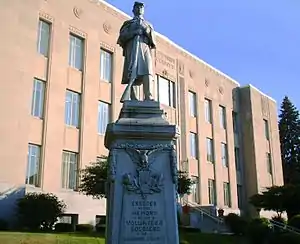 Goodhue County Courthouse in Red Wing, Minnesota | |
 Flag  Seal | |
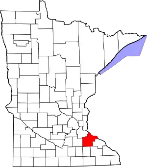 Location within the U.S. state of Minnesota | |
 Minnesota's location within the U.S. | |
| Coordinates: 44°25′N 92°43′W | |
| Country | |
| State | |
| Founded | March 5, 1853 |
| Named for | James M. Goodhue |
| Seat | Red Wing |
| Largest city | Red Wing |
| Area | |
| • Total | 780 sq mi (2,000 km2) |
| • Land | 757 sq mi (1,960 km2) |
| • Water | 24 sq mi (60 km2) 3.0%% |
| Population (2010) | |
| • Total | 46,183 |
| • Estimate (2019) | 46,340 |
| • Density | 61.2/sq mi (23.6/km2) |
| Time zone | UTC−6 (Central) |
| • Summer (DST) | UTC−5 (CDT) |
| Congressional district | 2nd |
| Website | www |
Goodhue County comprises the Red Wing, MN Micropolitan Statistical Area and is included in the Minneapolis-St. Paul, MN-WI Combined Statistical Area.
History
The county was created on March 5, 1853, with territory partitioned from Wabasha County. It was named for James Madison Goodhue (1810–1852), who published the first newspaper in the territory, The Minnesota Pioneer.[3][4]
The county was originally settled exclusively by "Yankee" settlers, meaning that they both came to Goodhue County either directly from the six New England states or from upstate New York, where they were born to parents who had moved to that region from the six New England states in the immediate aftermath of the American Revolution, and that they were descended from the English Puritans who emigrated to North America during the early 1600s. Because of the prevalence of New Englanders and New England transplants from upstate New York the county was said to have a "distinctly New England character". While this was true of many neighboring counties it was considered exceptionally true of Goodhue County. The New Englanders brought with them many of their New England values, including a love of education and fervent support of the abolitionist movement.[5] When the New Englanders arrived, they laid out farms, established post routes, and built schools and government buildings out of locally available materials.[6] The New Englanders and their descendants made up the great majority of Goodhue County's inhabitants until the late 19th and early 20th century, when immigrants from Germany and Norway began arriving in the Minnesota-Wisconsin border region in large numbers. There were small numbers of immigrants from Germany, Norway and Sweden during the first several decades of Goodhue County's history as well.[7]
Hamline University, Minnesota's first college of higher learning, was started in Red Wing in 1854. It closed during the Civil War, and reopened in 1869 in Saint Paul.
The county was a leading producer of wheat during the mid-19th century, and for several years the county boasted the highest wheat production in the country. Fires at two of Red Wing's mills in the 1880s and developing railroad routes across Minnesota encouraged farmers from neighboring counties to begin sending their wheat to Minneapolis mills, reducing the county's importance in the wheat trade around the start of the 20th century.
The first municipal swimming pool in the state was built in Goodhue County.
In October 1960, President Dwight D. Eisenhower visited the county for a bridge dedication ceremony. The Hiawatha Bridge had been built to replace the Old High Bridge that spanned the Mississippi River since 1895. This visit drew 20,000 people. Eisenhower hoped his visit would help in the elections, swaying Minnesota voters to vote for Richard Nixon in the 1960 presidential election in the coming month. But John F. Kennedy carried the state on his way to being elected the next president.
Geography
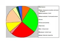
Goodhue County lies on Minnesota's border with Wisconsin (across Lake Pepin). The Cannon River flows eastward through the northern part of the county on its way to discharge into Lake Pepin. The Little Cannon River flows northward through the west-central part of the county, discharging into the Cannon River at Cannon Falls. The North Fork of the Zumbro River flows eastward through the lower part of the county. The county terrain consists of rolling hills, etched with drainages and gullies, and with high bluffs against the river valleys.[9] The terrain slopes to the east and north; its highest point is near its southwest corner at 1,260' (384m) ASL.[10] The county has an area of 780 square miles (2,000 km2), of which 757 square miles (1,960 km2) is land and 24 square miles (62 km2) (3.0%) is water.[11] Goodhue is one of 17 Minnesota counties with more savanna soils than either prairie or forest soils.
Lakes[9]
- Birch Lake
- Brewer Lake
- Cannon Lake
- Clear Lake
- Devils Lake
- Espen Lakes
- Goose Lake
- Lake Byllesby
- Larson Lake
- Nelson Lake
- North Lake
- Rattling Springs Lake
- Spring Banks Lake
- Spring Creek Lake
- Sturgeon Lake
- Twin Lakes
Major highways
 U.S. Highway 52
 U.S. Highway 61
 U.S. Highway 63
 Minnesota State Highway 19
 Minnesota State Highway 20
 Minnesota State Highway 56
 Minnesota State Highway 57
 Minnesota State Highway 58
 Minnesota State Highway 60
 Minnesota State Highway 246
 Minnesota State Highway 292
 Minnesota State Highway 316
- List of county roads
Adjacent counties
- Pierce County, Wisconsin - north
- Pepin County, Wisconsin - northeast
- Wabasha County - east
- Olmsted County - southeast
- Dodge County - south
- Rice County - west
- Dakota County - northwest
Protected areas[9]
- Cannon River Turtle Preserve Scientific and Natural Area
- Frontenac State Park
- Miesville Ravine Park Reserve (part)
- North Fork Zumbro Woods Scientific and Natural Area
- Spring Creek Prairie Scientific and Natural Area
- Woodbury State Wildlife Management Area
Demographics
| Historical population | |||
|---|---|---|---|
| Census | Pop. | %± | |
| 1860 | 8,977 | — | |
| 1870 | 22,018 | 145.3% | |
| 1880 | 29,651 | 34.7% | |
| 1890 | 28,806 | −2.8% | |
| 1900 | 31,137 | 8.1% | |
| 1910 | 31,637 | 1.6% | |
| 1920 | 30,799 | −2.6% | |
| 1930 | 31,317 | 1.7% | |
| 1940 | 31,564 | 0.8% | |
| 1950 | 32,118 | 1.8% | |
| 1960 | 33,035 | 2.9% | |
| 1970 | 34,804 | 5.4% | |
| 1980 | 38,749 | 11.3% | |
| 1990 | 40,690 | 5.0% | |
| 2000 | 44,127 | 8.4% | |
| 2010 | 46,183 | 4.7% | |
| 2019 (est.) | 46,340 | [12] | 0.3% |
| US Decennial Census[13] 1790-1960[14] 1900-1990[15] 1990-2000[16] 2010-2019[1] | |||

2000 census
As of the 2000 United States Census, there were 44,127 people, 16,983 households, and 11,905 families in the county. The population density was 58.3/sqmi (22.5/km2). There were 17,879 housing units at an average density of 23.6/sqmi (9.12/km2). The racial makeup of the county was 96.57% White, 0.63% Black or African American, 0.98% Native American, 0.57% Asian, 0.03% Pacific Islander, 0.53% from other races, and 0.69% from two or more races. 1.07% of the population were Hispanic or Latino of any race.
There were 16,983 households, out of which 33.80% had children under the age of 18 living with them, 59.20% were married couples living together, 7.20% had a female householder with no husband present, and 29.90% were non-families. 25.20% of all households were made up of individuals, and 11.50% had someone living alone who was 65 years of age or older. The average household size was 2.53 and the average family size was 3.04.
The county population contained 26.50% under the age of 18, 7.40% from 18 to 24, 27.90% from 25 to 44, 23.20% from 45 to 64, and 15.00% who were 65 years of age or older. The median age was 38 years. For every 100 females there were 98.10 males. For every 100 females age 18 and over, there were 95.40 males.
The median income for a household in the county was $46,972, and the median income for a family was $55,689. Males had a median income of $36,282 versus $25,442 for females. The per capita income for the county was $21,934. About 3.70% of families and 5.70% of the population were below the poverty line, including 6.20% of those under age 18 and 8.60% of those age 65 or over.
Communities
Cities
- Bellechester (part)
- Cannon Falls
- Dennison (part)
- Goodhue
- Kenyon
- Lake City (part)
- Pine Island (part)
- Red Wing (county seat)
- Wanamingo
- Zumbrota
Census-designated place
Unincorporated communities
Ghost town
Townships
- Belle Creek Township
- Belvidere Township
- Cannon Falls Township
- Cherry Grove Township
- Featherstone Township
- Florence Township
- Goodhue Township
- Hay Creek Township
- Holden Township
- Kenyon Township
- Leon Township
- Minneola Township
- Pine Island Township
- Roscoe Township
- Stanton Township
- Vasa Township
- Wacouta Township
- Wanamingo Township
- Warsaw Township
- Welch Township
- Zumbrota Township
Government and politics
Goodhue County usually leans Republican. As of 2016 it has selected the Republican candidate in 78% of presidential elections since 1980.
| Year | Republican | Democratic | Third parties |
|---|---|---|---|
| 2016 | 54.6% 14,041 | 36.7% 9,446 | 8.7% 2,230 |
| 2012 | 50.3% 12,986 | 47.3% 12,212 | 2.3% 603 |
| 2008 | 49.5% 12,775 | 48.2% 12,420 | 2.3% 600 |
| 2004 | 51.3% 13,134 | 47.3% 12,103 | 1.5% 371 |
| 2000 | 48.8% 10,852 | 44.8% 9,981 | 6.4% 1,424 |
| 1996 | 35.9% 7,293 | 48.9% 9,931 | 15.2% 3,094 |
| 1992 | 34.5% 7,321 | 37.3% 7,916 | 28.3% 6,013 |
| 1988 | 49.5% 9,455 | 49.4% 9,438 | 1.1% 209 |
| 1984 | 55.9% 11,171 | 43.4% 8,679 | 0.6% 128 |
| 1980 | 46.1% 9,329 | 42.3% 8,566 | 11.6% 2,353 |
| 1976 | 51.6% 9,967 | 46.2% 8,926 | 2.2% 428 |
| 1972 | 63.0% 11,107 | 34.9% 6,147 | 2.1% 377 |
| 1968 | 51.9% 8,283 | 45.2% 7,220 | 2.9% 461 |
| 1964 | 42.0% 6,539 | 58.0% 9,035 | 0.1% 15 |
| 1960 | 65.2% 10,473 | 34.6% 5,562 | 0.2% 38 |
| 1956 | 65.3% 9,365 | 34.6% 4,969 | 0.1% 19 |
| 1952 | 67.3% 10,422 | 32.5% 5,037 | 0.2% 35 |
| 1948 | 47.1% 6,704 | 51.4% 7,313 | 1.4% 205 |
| 1944 | 57.2% 7,820 | 42.3% 5,791 | 0.5% 68 |
| 1940 | 58.1% 9,095 | 41.4% 6,475 | 0.6% 86 |
| 1936 | 39.6% 5,682 | 57.5% 8,257 | 2.9% 422 |
| 1932 | 41.2% 5,486 | 56.0% 7,450 | 2.8% 374 |
| 1928 | 72.9% 9,752 | 26.3% 3,520 | 0.8% 100 |
| 1924 | 59.1% 6,849 | 5.3% 615 | 35.7% 4,135 |
| 1920 | 85.1% 9,330 | 10.2% 1,118 | 4.7% 520 |
| 1916 | 61.4% 3,471 | 33.2% 1,875 | 5.5% 308 |
| 1912 | 18.3% 1,051 | 24.5% 1,405 | 57.2% 3,283 |
| 1908 | 74.9% 4,482 | 19.2% 1,147 | 6.0% 356 |
| 1904 | 83.4% 4,562 | 13.4% 735 | 3.1% 171 |
| 1900 | 78.5% 4,894 | 18.1% 1,125 | 3.4% 212 |
| 1896 | 77.9% 5,748 | 19.3% 1,426 | 2.8% 208 |
| 1892 | 61.6% 3,574 | 28.6% 1,659 | 9.8% 569 |
| Position | Name | District | Next Election | |
|---|---|---|---|---|
| Commissioner | Linda Flanders | District 1 | 2020 | |
| Commissioner and Chair | Brad Anderson | District 2 | 2022 | |
| Commissioner | Barney Nesseth | District 3 | 2020 | |
| Commissioner | Jason Majerus | District 4 | 2022 | |
| Commissioner and Vice Chair | Paul Drotos | District 5 | 2020 | |
| Position | Name | Affiliation | District | |
|---|---|---|---|---|
| Senate | Mike Goggin[19] | Republican | District 21 | |
| Senate | Matt Little[20] | Democrat | District 58 | |
| House of Representatives | Barb Haley[21] | Republican | District 21A | |
| House of Representatives | Steve Drazkowski[22] | Republican | District 21B | |
| House of Representatives | Pat Garofalo[23] | Republican | District 58B | |
| Position | Name | Affiliation | District | |
|---|---|---|---|---|
| House of Representatives | Angie Craig[24] | Democrat | 2nd | |
| Senate | Amy Klobuchar[25] | Democrat | N/A | |
| Senate | Tina Smith[26] | Democrat | N/A | |
See also
- List of County Roads in Goodhue County, Minnesota
- National Register of Historic Places listings in Goodhue County, Minnesota
References
- "State & County QuickFacts". United States Census Bureau. Archived from the original on June 7, 2011. Retrieved August 31, 2013.
- "Find a County". National Association of Counties. Archived from the original on May 31, 2011. Retrieved June 7, 2011.
- Minnesota Geographic Names, Warren Upham (1920). "Goodhue was a man of very forcible character and of high moral principles . . " (accessed March 9, 2019)
- Gannett, Henry (1905). The Origin of Certain Place Names in the United States. Govt. Print. Off. p. 139.
- History of Goodhue County, Minnesota By Franklyn Curtiss-Wedge, pp. 9, 71, 108, 138-140, 155, 163, 213, 254, 259-261
- History of Goodhue County, Minnesota By Franklyn Curtiss-Wedge pp.. 97, 202, 271
- History of Goodhue County, Minnesota By Franklyn Curtiss-Wedge pp. 340-354, 365-383
- Nelson, Steven (2011). Savanna Soils of Minnesota. Minnesota:Self. pp. 43-48. ISBN 978-0-615-50320-2
- Goodhue County MN Google Maps (accessed March 9, 2019)
- ""Find an Altitude/Goodhue County MN" Google Maps (accessed 9 March 2019)". Archived from the original on May 21, 2019. Retrieved March 9, 2019.
- "2010 Census Gazetteer Files". US Census Bureau. August 22, 2012. Archived from the original on October 6, 2014. Retrieved October 15, 2014.
- "Population and Housing Unit Estimates". Retrieved March 26, 2020.
- "US Decennial Census". US Census Bureau. Archived from the original on April 26, 2015. Retrieved October 15, 2014.
- "Historical Census Browser". University of Virginia Library. Retrieved October 15, 2014.
- "Population of Counties by Decennial Census: 1900 to 1990". US Census Bureau. Retrieved October 15, 2014.
- "Census 2000 PHC-T-4. Ranking Tables for Counties: 1990 and 2000" (PDF). US Census Bureau. Retrieved October 15, 2014.
- Leip, David. "Atlas of US Presidential Elections". uselectionatlas.org. Retrieved April 6, 2018.
- "County Board | Goodhue County, MN - Official Website". co.goodhue.mn.us. Retrieved June 26, 2020.
- "MN State Senate". www.senate.mn. Retrieved June 26, 2020.
- "MN State Senate". www.senate.mn. Retrieved June 26, 2020.
- "Rep. Barb Haley (21A) - Minnesota House of Representatives". www.house.leg.state.mn.us. Retrieved June 26, 2020.
- "Rep. Steve Drazkowski (21B) - Minnesota House of Representatives". www.house.leg.state.mn.us. Retrieved June 26, 2020.
- "Rep. Pat Garofalo (58B) - Minnesota House of Representatives". www.house.leg.state.mn.us. Retrieved June 26, 2020.
- "Representative Angie Craig". Representative Angie Craig. Retrieved June 26, 2020.
- "U.S. Senator Amy Klobuchar". www.klobuchar.senate.gov. Retrieved June 24, 2020.
- "Home". Senator Tina Smith. Retrieved June 24, 2020.
External links
Places adjacent to Goodhue County, Minnesota | ||||||||||
|---|---|---|---|---|---|---|---|---|---|---|
| ||||||||||
Municipalities and communities of Goodhue County, Minnesota, United States | ||
|---|---|---|
| Cities | Map of Minnesota highlighting Goodhue County | |
| Townships | ||
| CDP | ||
| Unincorporated communities | ||
| Indian reservation | ||
| Ghost towns/Neighborhoods | ||
| Footnotes | ‡This populated place also has portions in an adjacent county or counties | |
| ||

| Authority control |
|---|