Steele County, Minnesota
Steele County is a county in the U.S. state of Minnesota. As of the 2010 United States Census, the population was 36,576.[1] Its county seat is Owatonna.[2]
Steele County | |
|---|---|
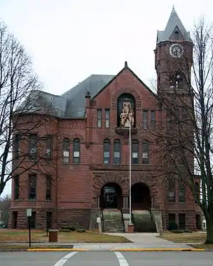 Steele County Courthouse in Owatonna | |
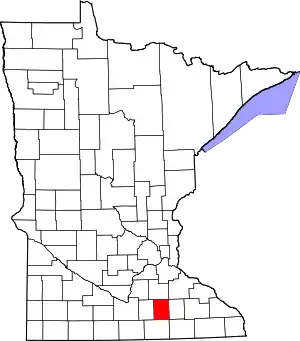 Location within the U.S. state of Minnesota | |
 Minnesota's location within the U.S. | |
| Coordinates: 44°01′N 93°13′W | |
| Country | |
| State | |
| Founded | February 20, 1855 |
| Named for | Franklin Steele |
| Seat | Owatonna |
| Largest city | Owatonna |
| Area | |
| • Total | 432 sq mi (1,120 km2) |
| • Land | 430 sq mi (1,100 km2) |
| • Water | 2.7 sq mi (7 km2) 0.6%% |
| Population (2010) | |
| • Total | 36,576 |
| • Estimate (2019) | 36,649 |
| • Density | 85.8/sq mi (33.1/km2) |
| Time zone | UTC−6 (Central) |
| • Summer (DST) | UTC−5 (CDT) |
| Congressional district | 1st |
| Website | www |
Steele County comprises the Owatonna, MN Micropolitan Statistical Area.
History
The county was created by the Minnesota Territory legislature on 20 February 1855, using areas partitioned from Rice, Blue Earth, and Le Sueur counties. Owatonna, the settlement of which had commenced in 1854, was named the county seat. The county was named for Franklin Steele, a prominent early resident of the territory.[3]
Geography
The Straight River rises in Freeborn County and flows northward through the central part of Steele County, continuing into Rice County on the north. The South Branch of the Middle Fork of the Zumbro River rises in Steele County and flows eastward into Dodge County. The county terrain consists of low rolling hills, etched with drainages, completely devoted to agriculture where possible.[5] The terrain slopes to the east and north, with its highest point near the midpoint of its south border, at 1,293' (394m) ASL.[6] The county has an area of 432 square miles (1,120 km2), of which 430 square miles (1,100 km2) is land and 2.7 square miles (7.0 km2) (0.6%) is water.[7]
The Straight River flows northward through the county, and the Le Sueur River flows through its southwestern corner. The Middle Fork of the Zumbro River rises in NE Steele County.[8]
Major highways
 Interstate 35 – runs north–south through west-central portion of county. Passes Medford, Clinton Falls, Owatonna, Hope, Ellendale.
 U.S. Highway 14 – runs east–west through upper central portion of county. Passes Owatonna.
.svg.png.webp) U.S. Highway 218 – runs NNW from southeast corner of county to intersection with US-14, southeast of Owatonna.
U.S. Highway 218 – runs NNW from southeast corner of county to intersection with US-14, southeast of Owatonna. Minnesota State Highway 30 – runs east–west across south part of county. Passes Ellendale.
Airports[5]
- Owatonna Degner Regional Airport (OWA) - northwest of Owatonna
Adjacent counties
- Rice County – north
- Dodge County – east
- Mower County – southeast
- Freeborn County – south
- Waseca County – west
Protected areas[5]
- Aurora State Wildlife Management Area
- Oak Glen State Wildlife Management Area
- Rice Lake State Park
- Somerset State Wildlife Management Area
- Swan Lake State Wildlife Management Area
Lakes[5]
- Beaver Lake
- Fosilen Lake
- Lake Kohlmeier
- Lonergan Lake
- Oak Glen Lake
- Rice Lake (part)
- Rickert Lake
- Swan Lake
Demographics
| Historical population | |||
|---|---|---|---|
| Census | Pop. | %± | |
| 1860 | 2,863 | — | |
| 1870 | 8,271 | 188.9% | |
| 1880 | 12,400 | 49.9% | |
| 1890 | 13,232 | 6.7% | |
| 1900 | 16,524 | 24.9% | |
| 1910 | 16,146 | −2.3% | |
| 1920 | 18,061 | 11.9% | |
| 1930 | 18,475 | 2.3% | |
| 1940 | 19,749 | 6.9% | |
| 1950 | 21,155 | 7.1% | |
| 1960 | 25,029 | 18.3% | |
| 1970 | 26,931 | 7.6% | |
| 1980 | 30,328 | 12.6% | |
| 1990 | 30,729 | 1.3% | |
| 2000 | 33,680 | 9.6% | |
| 2010 | 36,575 | 8.6% | |
| 2019 (est.) | 36,649 | [9] | 0.2% |
| US Decennial Census[10] 1790-1960[11] 1900-1990[12] 1990-2000[13] 2010-2019[1] | |||
2000 census
As of the 2000 United States Census, there were 33,680 people, 12,846 households, and 9,082 families in the county. The population density was 78.3/sqmi (30.2/km2). There were 13,306 housing units at an average density of 30.9/sqmi (11.9/km2). The racial makeup of the county was 95.19% White, 1.07% Black or African American, 0.10% Native American, 0.85% Asian, 0.02% Pacific Islander, 1.65% from other races, and 1.12% from two or more races. 3.76% of the population were Hispanic or Latino of any race. 38.6% were of German, 18.5% Norwegian, 5.2% Czech and 5.1% Irish ancestry.
There were 12,846 households, out of which 35.50% had children under the age of 18 living with them, 59.50% were married couples living together, 7.40% had a female householder with no husband present, and 29.30% were non-families. 24.60% of all households were made up of individuals, and 10.30% had someone living alone who was 65 years of age or older. The average household size was 2.57 and the average family size was 3.08.
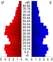
The county population contained 27.90% under the age of 18, 8.20% from 18 to 24, 29.00% from 25 to 44, 21.60% from 45 to 64, and 13.30% who were 65 years of age or older. The median age was 36 years. For every 100 females there were 97.50 males. For every 100 females age 18 and over, there were 95.00 males.
The median income for a household in the county was $46,106, and the median income for a family was $53,981. Males had a median income of $36,366 versus $25,054 for females. The per capita income for the county was $20,328. About 4.20% of families and 6.20% of the population were below the poverty line, including 7.10% of those under age 18 and 7.10% of those age 65 or over.
Communities
Cities
- Blooming Prairie (partly in Dodge County)
- Ellendale
- Medford
- Owatonna (county seat)
Unincorporated communities
Ghost town
Politics
Steele County voters have traditionally voted Republican. In only one national election since 1964 has the county selected the Democratic Party candidate (as of 2016).
| Year | Republican | Democratic | Third parties |
|---|---|---|---|
| 2016 | 58.4% 11,198 | 32.5% 6,241 | 9.1% 1,740 |
| 2012 | 51.8% 9,903 | 45.5% 8,706 | 2.7% 515 |
| 2008 | 51.2% 10,068 | 45.9% 9,016 | 2.9% 572 |
| 2004 | 55.6% 10,389 | 42.8% 7,994 | 1.7% 312 |
| 2000 | 51.2% 8,223 | 43.0% 6,900 | 5.9% 943 |
| 1996 | 37.5% 5,617 | 46.6% 6,974 | 15.9% 2,373 |
| 1992 | 37.8% 5,964 | 32.6% 5,152 | 29.6% 4,673 |
| 1988 | 58.6% 7,981 | 40.4% 5,496 | 1.0% 133 |
| 1984 | 63.1% 8,780 | 36.4% 5,060 | 0.5% 70 |
| 1980 | 54.7% 7,805 | 35.7% 5,095 | 9.7% 1,379 |
| 1976 | 51.7% 7,053 | 45.9% 6,263 | 2.4% 331 |
| 1972 | 64.7% 7,678 | 33.8% 4,010 | 1.5% 180 |
| 1968 | 55.3% 6,193 | 41.4% 4,631 | 3.3% 366 |
| 1964 | 44.6% 4,882 | 55.1% 6,022 | 0.3% 35 |
| 1960 | 60.1% 6,795 | 39.7% 4,491 | 0.1% 15 |
| 1956 | 65.9% 6,435 | 33.7% 3,293 | 0.4% 36 |
| 1952 | 71.0% 6,956 | 28.8% 2,819 | 0.3% 29 |
| 1948 | 50.5% 4,451 | 48.8% 4,305 | 0.7% 60 |
| 1944 | 58.9% 4,760 | 40.9% 3,307 | 0.2% 15 |
| 1940 | 60.0% 5,517 | 39.9% 3,668 | 0.2% 14 |
| 1936 | 41.0% 3,373 | 54.5% 4,481 | 4.5% 370 |
| 1932 | 43.2% 3,365 | 55.4% 4,318 | 1.4% 107 |
| 1928 | 62.5% 4,744 | 37.2% 2,826 | 0.3% 25 |
| 1924 | 59.5% 3,598 | 13.2% 796 | 27.3% 1,653 |
| 1920 | 76.5% 4,243 | 21.0% 1,167 | 2.5% 140 |
| 1916 | 52.2% 1,734 | 45.1% 1,497 | 2.7% 91 |
| 1912 | 20.3% 651 | 40.4% 1,294 | 39.2% 1,255 |
| 1908 | 57.1% 1,899 | 38.6% 1,284 | 4.3% 142 |
| 1904 | 63.4% 2,095 | 32.3% 1,067 | 4.3% 141 |
| 1900 | 58.3% 1,833 | 37.8% 1,188 | 3.9% 122 |
| 1896 | 59.4% 2,046 | 36.2% 1,248 | 4.4% 150 |
| 1892 | 48.7% 1,396 | 45.3% 1,299 | 6.0% 171 |
See also
References
- "State & County QuickFacts". US Census Bureau. Retrieved September 1, 2013.
- "Find a County". National Association of Counties. Retrieved 7 June 2011.
- Upham, Warren (1920). Minnesota Geographic Names: Their Origin and Historic Significance. Minnesota Historical Society. p. 531. Retrieved April 19, 2019.
- Nelson, Steven (2011). Savanna Soils of Minnesota. Minnesota: Self. pp. 43-48. ISBN 978-0-615-50320-2.
- Steele County MN Google Maps (accessed 19 April 2019)
- "Find an Altitude/Steele County MN" Google Maps (accessed 19 April 2019)
- "2010 Census Gazetteer Files". US Census Bureau. August 22, 2012. Archived from the original on September 21, 2013. Retrieved October 25, 2014.
- Minnesota Atlas & Gazetteer. Yarmouth ME: DeLorme. 1994. pp. 24, 33. ISBN 0-89933-222-6.
- "Population and Housing Unit Estimates". Retrieved March 26, 2020.
- "US Decennial Census". US Census Bureau. Retrieved October 25, 2014.
- "Historical Census Browser". University of Virginia Library. Retrieved October 25, 2014.
- "Population of Counties by Decennial Census: 1900 to 1990". US Census Bureau. Retrieved October 25, 2014.
- "Census 2000 PHC-T-4. Ranking Tables for Counties: 1990 and 2000" (PDF). US Census Bureau. Retrieved October 25, 2014.
- Leip, David. "Atlas of US Presidential Elections". uselectionatlas.org. Retrieved October 10, 2018.
External links
Places adjacent to Steele County, Minnesota | ||||||||||
|---|---|---|---|---|---|---|---|---|---|---|
| ||||||||||
Municipalities and communities of Steele County, Minnesota, United States | ||
|---|---|---|
| Cities | Map of Minnesota highlighting Steele County | |
| Townships | ||
| Unincorporated communities | ||
| Ghost town | ||
| Footnotes | ‡This populated place also has portions in an adjacent county or counties | |
| ||

| Authority control |
|---|