Pipestone County, Minnesota
Pipestone County is a county in the U.S. state of Minnesota. As of the 2010 United States Census, the population was 9,596.[2] Its county seat is Pipestone.[3]
Pipestone County | |
|---|---|
 | |
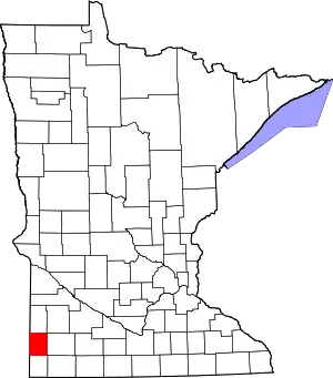 Location within the U.S. state of Minnesota | |
 Minnesota's location within the U.S. | |
| Coordinates: 44°01′N 96°15′W | |
| Country | |
| State | |
| Founded | May 23, 1857 (created) 1879 (organized)[1] |
| Named for | Pipestone |
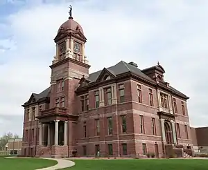
| Seat | Pipestone |
| Largest city | Pipestone |
| Area | |
| • Total | 466 sq mi (1,210 km2) |
| • Land | 465 sq mi (1,200 km2) |
| • Water | 0.9 sq mi (2 km2) 0.2%% |
| Population (2010) | |
| • Total | 9,596 |
| • Estimate (2019) | 9,126 |
| • Density | 19.5/sq mi (7.5/km2) |
| Time zone | UTC−6 (Central) |
| • Summer (DST) | UTC−5 (CDT) |
| Congressional district | 7th |
| Website | www |
History
The county was created (as Rock County) by the Minnesota Territory legislature on May 23, 1857. An act of the Minnesota state legislature on February 20, 1862 changed the county name to Pipestone, due to the pipestone quarry located in this county. County organization was effected by a state act dated January 27, 1879, with Pipestone City (which had been platted in 1876) as the county seat (the name of the county seat was later shortened to Pipestone).[4] The pipestones are from deposits of red pipestone used by Native Americans to make pipes.[5]
Pipestone National Monument is located in the county, just north of the town of Pipestone.
Geography
Pipestone County lies on the west line of Minnesota. Its west border abuts the east border of the state of South Dakota. The Rock River rises in the county and flows southward into Rock County, being augmented by the East Branch of the Rock River near the south border. The terrain consists of low rolling hills, carved by drainages. The area is devoted to agriculture.[6] The terrain slopes to the west and south, with its highest point on the upper part of its east border, at 1,883' (574m) ASL.[7] The county has a total area of 466 square miles (1,210 km2), of which 465 square miles (1,200 km2) is land and 0.9 square miles (2.3 km2) (0.2%) is water.[8]

Major highways
Adjacent counties
- Lincoln County - north
- Lyon County - northeast
- Murray County - east
- Rock County - south
- Minnehaha County, South Dakota - southwest
- Moody County, South Dakota - west
- Brookings County, South Dakota - northwest
Protected areas[6]
- Altona State Wildlife Management Area
- Burke State Wildlife Management Area
- Holland State Wildlife Management Area
- Pheasant Terrace State Wildlife Management Area
- Pipestone Indian State Wildlife Management Area (within Pipestone Natl Monument)
- Pipestone National Monument
- Prairie Coteau Scientific and Natural Area
- Split Rock Creek State Park
- Troy State Wildlife Management Area
- Van Beek State Wildlife Management Area
- Woodstock State Wildlife Management Area
Lakes
Despite Pipestone County not containing any natural lakes (the other three being Mower, Olmsted and Rock), it does have man-made reservoirs:
- Indian Lake[6]
- Split Rock Lake: in Split Rock Creek State Park
Demographics
| Historical population | |||
|---|---|---|---|
| Census | Pop. | %± | |
| 1880 | 2,092 | — | |
| 1890 | 5,132 | 145.3% | |
| 1900 | 9,264 | 80.5% | |
| 1910 | 9,553 | 3.1% | |
| 1920 | 12,050 | 26.1% | |
| 1930 | 12,238 | 1.6% | |
| 1940 | 13,794 | 12.7% | |
| 1950 | 14,003 | 1.5% | |
| 1960 | 13,605 | −2.8% | |
| 1970 | 12,791 | −6.0% | |
| 1980 | 11,690 | −8.6% | |
| 1990 | 10,491 | −10.3% | |
| 2000 | 9,895 | −5.7% | |
| 2010 | 9,596 | −3.0% | |
| 2019 (est.) | 9,126 | [10] | −4.9% |
| US Decennial Census[11] 1790-1960[12] 1900-1990[13] 1990-2000[14] 2010-2019[2] | |||

2000 census
As of the 2000 United States Census, there were 9,895 people, 4,069 households, and 2,726 families in the county. The population density was 21.3/sqmi (8.22/km2). There were 4,434 housing units at an average density of 9.54/sqmi (3.68/km2). The racial makeup of the county was 96.68% White, 0.17% Black or African American, 1.48% Native American, 0.46% Asian, 0.02% Pacific Islander, 0.26% from other races, and 0.93% from two or more races. 0.70% of the population were Hispanic or Latino of any race. 35.7% were of German, 24.8% Dutch and 14.3% Norwegian ancestry.
There were 4,069 households, out of which 31.00% had children under the age of 18 living with them, 57.60% were married couples living together, 6.50% had a female householder with no husband present, and 33.00% were non-families. 30.10% of all households were made up of individuals, and 17.20% had someone living alone who was 65 years of age or older. The average household size was 2.38 and the average family size was 2.96.
The county population contained 25.80% under the age of 18, 6.80% from 18 to 24, 24.60% from 25 to 44, 21.40% from 45 to 64, and 21.30% who were 65 years of age or older. The median age was 40 years. For every 100 females there were 92.80 males. For every 100 females age 18 and over, there were 89.40 males.
The median income for a household in the county was $31,909, and the median income for a family was $40,133. Males had a median income of $27,642 versus $20,759 for females. The per capita income for the county was $16,450. About 7.80% of families and 9.50% of the population were below the poverty line, including 11.20% of those under age 18 and 11.10% of those age 65 or over.
Communities

Cities
Unincorporated communities
Government and Politics
In recent decades the voters of Pipestone County have trended Republican. In no national election since 1976 has the county selected the Democratic Party candidate (as of 2016). In 2012 it was one of only two counties not to vote for Democratic Senate candidate Amy Klobuchar.[15]
| Year | Republican | Democratic | Third parties |
|---|---|---|---|
| 2020 | 71.9% 3,553 | 26.4% 1,306 | 1.7% 81 |
| 2016 | 69.4% 3,338 | 23.4% 1,127 | 7.1% 343 |
| 2012 | 60.8% 2,826 | 37.1% 1,725 | 2.0% 95 |
| 2008 | 55.2% 2,652 | 42.1% 2,023 | 2.6% 126 |
| 2004 | 60.9% 3,066 | 37.8% 1,900 | 1.3% 66 |
| 2000 | 55.0% 2,693 | 40.3% 1,970 | 4.7% 231 |
| 1996 | 44.4% 2,096 | 42.3% 1,999 | 13.3% 627 |
| 1992 | 37.8% 1,953 | 34.3% 1,773 | 27.9% 1,444 |
| 1988 | 53.2% 2,760 | 45.9% 2,382 | 0.9% 47 |
| 1984 | 55.3% 3,043 | 43.5% 2,391 | 1.2% 67 |
| 1980 | 51.4% 3,207 | 38.3% 2,392 | 10.3% 644 |
| 1976 | 47.2% 3,018 | 51.1% 3,272 | 1.7% 111 |
| 1972 | 55.6% 3,543 | 43.3% 2,758 | 1.2% 75 |
| 1968 | 56.5% 3,241 | 38.9% 2,234 | 4.6% 263 |
| 1964 | 42.4% 2,481 | 57.5% 3,365 | 0.1% 5 |
| 1960 | 60.0% 3,677 | 39.9% 2,443 | 0.2% 11 |
| 1956 | 60.8% 3,362 | 39.1% 2,165 | 0.1% 6 |
| 1952 | 72.5% 4,507 | 27.3% 1,701 | 0.2% 13 |
| 1948 | 44.0% 2,281 | 54.1% 2,804 | 1.8% 95 |
| 1944 | 57.0% 2,844 | 42.6% 2,129 | 0.4% 21 |
| 1940 | 58.6% 3,423 | 40.9% 2,390 | 0.5% 29 |
| 1936 | 36.4% 1,881 | 58.5% 3,026 | 5.1% 263 |
| 1932 | 33.0% 1,509 | 65.4% 2,996 | 1.6% 73 |
| 1928 | 61.3% 2,578 | 37.8% 1,591 | 0.9% 38 |
| 1924 | 48.2% 2,066 | 5.1% 219 | 46.7% 2,005 |
| 1920 | 79.9% 3,106 | 12.6% 490 | 7.5% 292 |
| 1916 | 52.4% 1,010 | 38.0% 732 | 9.6% 184 |
| 1912 | 18.1% 301 | 30.4% 505 | 51.6% 858 |
| 1908 | 65.1% 1,057 | 30.2% 491 | 4.7% 76 |
| 1904 | 76.2% 1,185 | 17.3% 269 | 6.6% 102 |
| 1900 | 59.9% 1,112 | 37.2% 692 | 2.9% 54 |
| 1896 | 47.5% 862 | 50.6% 919 | 1.9% 34 |
| 1892 | 48.0% 648 | 21.8% 295 | 30.2% 408 |
| Position | Name | District | Next Election | |
|---|---|---|---|---|
| Commissioner | Luke Johnson | District 1 | 2020 | |
| Commissioner | Les Nath | District 2 | 2022 | |
| Commissioner and Chairperson | Bruce Kooiman | District 3 | 2020 | |
| Commissioner | Dan Wildermuth | District 4 | 2022 | |
| Commissioner | Chris Hollinsworth | District 5 | 2020 | |
| Position | Name | Affiliation | District | |
|---|---|---|---|---|
| Senate | Bill Weber[18] | Republican | District 22 | |
| House of Representatives | Joe Schomacker[19] | Republican | District 22A | |
| Position | Name | Affiliation | District | |
|---|---|---|---|---|
| House of Representatives | Collin Peterson[20] | Democrat | 7th | |
| Senate | Amy Klobuchar[21] | Democrat | N/A | |
| Senate | Tina Smith[22] | Democrat | N/A | |
References
- "Minnesota Place Names". Minnesota Historical Society. Archived from the original on October 28, 2014. Retrieved March 19, 2014.
- "State & County QuickFacts". United States Census Bureau. Archived from the original on June 7, 2011. Retrieved September 1, 2013.
- "Find a County". National Association of Counties. Archived from the original on May 31, 2011. Retrieved 7 June 2011.
- Uphame, Warren. Minnesota Geographic Names (1920), pp. 417-421 (accessed April 13, 2019)
- Chicago and North Western Railway Company (1908). A History of the Origin of the Place Names Connected with the Chicago & North Western and Chicago, St. Paul, Minneapolis & Omaha Railways. p. 163.
- Pipestone County MN Google Maps (accessed April 13, 2019)
- ""Find an Altitude/Pipestone County MN" Google Maps (accessed April 13, 2019)". Archived from the original on May 21, 2019. Retrieved April 13, 2019.
- "2010 Census Gazetteer Files". US Census Bureau. August 22, 2012. Archived from the original on September 21, 2013. Retrieved October 24, 2014.
- Nelson, Steven (2011). Savanna Soils of Minnesota. Minnesota: Self. pp. 69-70. ISBN 978-0-615-50320-2
- "Population and Housing Unit Estimates". Retrieved March 26, 2020.
- "US Decennial Census". US Census Bureau. Archived from the original on April 26, 2015. Retrieved October 24, 2014.
- "Historical Census Browser". University of Virginia Library. Retrieved October 24, 2014.
- "Population of Counties by Decennial Census: 1900 to 1990". US Census Bureau. Retrieved October 24, 2014.
- "Census 2000 PHC-T-4. Ranking Tables for Counties: 1990 and 2000" (PDF). US Census Bureau. Retrieved October 24, 2014.
- "Minnesota 2012 election results by county". Retrieved February 25, 2020.
- Leip, David. "Atlas of US Presidential Elections". uselectionatlas.org. Retrieved October 10, 2018.
- "Welcome to Pipestone County, MN". www.pipestone-county.com. Retrieved 2020-06-25.
- "MN State Senate". www.senate.mn. Retrieved 2020-06-25.
- "Rep. Joe Schomacker (22A) - Minnesota House of Representatives". www.house.leg.state.mn.us. Retrieved 2020-06-25.
- "Congressman Collin Peterson". Congressman Collin Peterson. Retrieved 2020-06-24.
- "U.S. Senator Amy Klobuchar". www.klobuchar.senate.gov. Retrieved 2020-06-24.
- "Home". Senator Tina Smith. Retrieved 2020-06-24.
External links
Places adjacent to Pipestone County, Minnesota | ||||||||||
|---|---|---|---|---|---|---|---|---|---|---|
| ||||||||||
Municipalities and communities of Pipestone County, Minnesota, United States | ||
|---|---|---|
| Cities | Map of Minnesota highlighting Pipestone County | |
| Townships | ||
| Unincorporated communities | ||
| Footnotes | ‡This populated place also has portions in an adjacent county or counties | |
| ||

| Authority control |
|---|