Carlton County, Minnesota
Carlton County is a county in the State of Minnesota, formed in 1857. As of the 2010 United States Census, the population was 35,386.[2] Its county seat is Carlton.[3] Part of the Fond du Lac Indian Reservation lies in northeastern Carlton County.
Carlton County | |
|---|---|
 | |
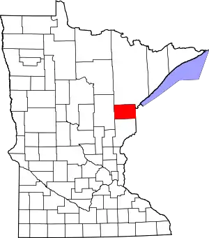 Location within the U.S. state of Minnesota | |
 Minnesota's location within the U.S. | |
| Coordinates: 46°35′N 92°41′W | |
| Country | |
| State | |
| Founded | May 23, 1857 (created) 1870 (organized)[1] |
| Named for | Reuben B. Carlton |
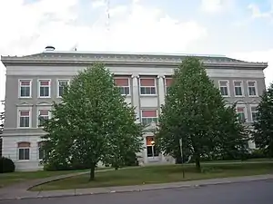
| Seat | Carlton |
| Largest city | Cloquet |
| Area | |
| • Total | 875 sq mi (2,270 km2) |
| • Land | 861 sq mi (2,230 km2) |
| • Water | 14 sq mi (40 km2) 1.6%% |
| Population (2010) | |
| • Total | 35,386 |
| • Estimate (2019) | 35,871 |
| • Density | 41.2/sq mi (15.9/km2) |
| Time zone | UTC−6 (Central) |
| • Summer (DST) | UTC−5 (CDT) |
| Congressional district | 8th |
| Website | www |
Carlton County is part of the Duluth, MN-WI Metropolitan Statistical Area.
Geography
Carlton County lies on Minnesota's eastern edge. Its eastern boundary abuts Wisconsin. The Saint Louis River flows east-southeast through the county, discharging into Lake Superior. The Moose Horn River flows southwest through the county, discharging into the Kettle River. The Nemadji River and the South Fork Nemadji River flow east through the county, meeting a few miles east of the its eastern boundary before reaching Lake Superior. The county terrain consists of low rolling hills, heavily wooded,[4] and slopes to the several river valleys. The county's northwest corner lies at 1,329' (405m) ASL,[5] and a small hill 0.2 miles (0.35 km) west of Rogers Lake[4] rises to 1,450' (442m) ASL.[6]
The county has an area of 875 square miles (2,270 km2), of which 861 square miles (2,230 km2) is land and 14 square miles (36 km2) (1.6%) is water.[7]
Major highways
Adjacent counties
- Saint Louis County - north
- Douglas County, Wisconsin - east
- Pine County - south
- Aitkin County - west
Protected areas[4]
- Black Hoof Wildlife Management Area
- Dye State Wildlife Management Area
- Fond du Lac State Forest (part)
- Jay Cooke State Park
- Kettle Lake State Wildlife Management Area
- Nemadji State Forest (part)
- Sawyer State Wildlife Management Area
History
Under a 1854 Treaty of La Pointe the Fond du Lac Indian Reservation and other reservations were established in exchange for all the Lake Superior Ojibwe land in the Arrowhead Region. Carlton County was formed and organized in 1870.[8] It was named for Reuben B. Carlton, a member of the Minnesota Senate (1857–58).[9]
In October 1918, an immense forest fire occurred, known as the Cloquet Fire. The Carlton County Historical Society hosts a permanent exhibit about the fire of 1918, along with ones about the Ojibwe of Carlton County and the Logging Era.[10]
Climate and weather
| Carlton, Minnesota | ||||||||||||||||||||||||||||||||||||||||||||||||||||||||||||
|---|---|---|---|---|---|---|---|---|---|---|---|---|---|---|---|---|---|---|---|---|---|---|---|---|---|---|---|---|---|---|---|---|---|---|---|---|---|---|---|---|---|---|---|---|---|---|---|---|---|---|---|---|---|---|---|---|---|---|---|---|
| Climate chart (explanation) | ||||||||||||||||||||||||||||||||||||||||||||||||||||||||||||
| ||||||||||||||||||||||||||||||||||||||||||||||||||||||||||||
| ||||||||||||||||||||||||||||||||||||||||||||||||||||||||||||
In recent years, average temperatures in the county seat of Carlton have ranged from a low of 1 °F (−17 °C) in January to a high of 80 °F (27 °C) in July, although a record low of −45 °F (−43 °C) was recorded in January 1912 and a record high of 105 °F (41 °C) was recorded in July 1936. Average monthly precipitation ranged from 0.87 inches (22 mm) in February to 4.34 inches (110 mm) in September.[11]
Demographics
| Historical population | |||
|---|---|---|---|
| Census | Pop. | %± | |
| 1860 | 51 | — | |
| 1870 | 286 | 460.8% | |
| 1880 | 1,230 | 330.1% | |
| 1890 | 5,272 | 328.6% | |
| 1900 | 10,017 | 90.0% | |
| 1910 | 17,559 | 75.3% | |
| 1920 | 19,391 | 10.4% | |
| 1930 | 21,232 | 9.5% | |
| 1940 | 24,212 | 14.0% | |
| 1950 | 24,584 | 1.5% | |
| 1960 | 27,932 | 13.6% | |
| 1970 | 28,072 | 0.5% | |
| 1980 | 29,936 | 6.6% | |
| 1990 | 29,259 | −2.3% | |
| 2000 | 31,671 | 8.2% | |
| 2010 | 35,386 | 11.7% | |
| 2019 (est.) | 35,871 | [12] | 1.4% |
| US Decennial Census[13] 1790-1960[14] 1900-1990[15] 1990-2000[16] 2010-2019[2] | |||
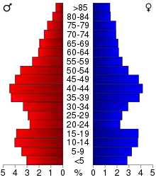
As of the 2010 United States Census, there were 35,386 people living in the county. 89.7% were White, 5.9% Native American, 1.4% Black or African American, 0.5% Asian, 0.2% of some other race and 2.4% of two or more races. 1.4% were Hispanic or Latino (of any race). 16.4% were of German, 13.5% Finnish, 8.9% Norwegian, 8.6% Swedish and 5.6% American ancestry.[17]
As of the 2000 census, there were 31,671 people, 12,064 households, and 8,408 families in the county. The population density was 36.8/sqmi (14.2/km2). There were 13,721 housing units at an average density of 15.9/sqmi (6.15/km2). The racial makeup of the county was 91.75% White, 0.97% Black or African American, 5.19% Native American, 0.35% Asian, 0.01% Pacific Islander, 0.21% from other races, and 1.52% from two or more races. 0.84% of the population were Hispanic or Latino of any race. 18.5% were of German, 16.9% Finnish, 12.5% Norwegian, 11.8% Swedish and 5.8% Polish ancestry. 95.5% spoke English, 1.8% Finnish and 1.1% Spanish as their first language.
There were 12,064 households, out of which 32.60% had children under the age of 18 living with them, 56.50% were married couples living together, 9.00% had a female householder with no husband present, and 30.30% were non-families. 26.10% of all households were made up of individuals, and 12.00% had someone living alone who was 65 years of age or older. The average household size was 2.50 and the average family size was 3.00.
The county population contained 25.40% under the age of 18, 7.70% from 18 to 24, 28.40% from 25 to 44, 23.50% from 45 to 64, and 15.10% who were 65 years of age or older. The median age was 38 years. For every 100 females there were 102.70 males. For every 100 females age 18 and over, there were 102.20 males.
The median income for a household in the county was $40,021, and the median income for a family was $48,406. Males had a median income of $38,788 versus $25,555 for females. The per capita income for the county was $18,073. About 5.40% of families and 7.90% of the population were below the poverty line, including 8.20% of those under age 18 and 9.30% of those age 65 or over.
Communities
Cities
- Barnum
- Carlton (county seat)
- Cloquet
- Cromwell
- Kettle River
- Moose Lake
- Scanlon
- Thomson
- Wrenshall
- Wright
Unincorporated communities
Townships
- Atkinson Township
- Automba Township
- Barnum Township
- Beseman Township
- Blackhoof Township
- Eagle Township
- Holyoke Township
- Kalevala Township
- Lakeview Township
- Mahtowa Township
- Moose Lake Township
- Perch Lake Township
- Silver Township
- Silver Brook Township
- Skelton Township
- Split Rock Township
- Thomson Township
- Twin Lakes Township
- Wrenshall Township
Unorganized territories
Government and politics
Local government
As of 2019, the Carlton County Sheriff is Kelly Lake.[18] The Carlton County Board of Commissioners has five members, each representing one district.[19] In April 2019 Lake and the Fond du Lac Police Department collaborated on sex trafficking training on behalf of other sheriff agencies that would be affected by the upcoming Enbridge Line 3.[20] In 2017, Carlton County published a detailed Jail & Criminal Justice System Planning Study.[21] As of 2019, Carlton County Public Health employs 36 county staff and 6 contract staff. It has been operating since 1920.[22]
National
Carlton County voters are traditionally Democratic. The Democratic Party has carried the county in every presidential election since 1928, though Donald Trump lost by only 300 votes in 2016 and 307 votes in 2020.
| Year | Republican | Democratic | Third parties |
|---|---|---|---|
| 2020 | 48.1% 9,791 | 49.6% 10,098 | 2.3% 480 |
| 2016 | 44.8% 8,160 | 46.5% 8,460 | 8.7% 1,591 |
| 2012 | 35.7% 6,586 | 61.8% 11,389 | 2.5% 461 |
| 2008 | 35.5% 6,549 | 62.3% 11,501 | 2.2% 399 |
| 2004 | 36.2% 6,642 | 62.5% 11,462 | 1.3% 230 |
| 2000 | 37.0% 5,578 | 57.2% 8,620 | 5.9% 883 |
| 1996 | 29.0% 4,034 | 57.9% 8,052 | 13.1% 1,829 |
| 1992 | 26.6% 3,922 | 52.5% 7,736 | 21.0% 3,089 |
| 1988 | 34.1% 4,626 | 64.8% 8,790 | 1.1% 144 |
| 1984 | 34.3% 4,877 | 64.7% 9,189 | 1.0% 137 |
| 1980 | 32.1% 4,760 | 59.5% 8,822 | 8.4% 1,251 |
| 1976 | 31.3% 4,371 | 66.3% 9,247 | 2.4% 334 |
| 1972 | 42.8% 5,445 | 55.9% 7,116 | 1.3% 169 |
| 1968 | 25.1% 3,016 | 71.0% 8,538 | 3.9% 464 |
| 1964 | 22.5% 2,780 | 77.3% 9,552 | 0.2% 27 |
| 1960 | 37.7% 4,613 | 62.0% 7,576 | 0.3% 35 |
| 1956 | 39.0% 4,168 | 60.7% 6,484 | 0.2% 25 |
| 1952 | 39.0% 4,175 | 60.1% 6,432 | 0.9% 91 |
| 1948 | 27.0% 2,742 | 68.6% 6,967 | 4.4% 448 |
| 1944 | 30.0% 2,653 | 69.5% 6,153 | 0.6% 50 |
| 1940 | 31.9% 3,400 | 67.1% 7,159 | 1.0% 111 |
| 1936 | 22.8% 2,163 | 75.3% 7,136 | 1.9% 179 |
| 1932 | 42.6% 3,336 | 45.8% 3,586 | 11.7% 916 |
| 1928 | 64.0% 4,582 | 29.9% 2,138 | 6.1% 438 |
| 1924 | 49.8% 3,142 | 4.8% 303 | 45.4% 2,869 |
| 1920 | 59.5% 2,833 | 24.2% 1,152 | 16.4% 779 |
| 1916 | 40.2% 1,096 | 40.9% 1,115 | 19.0% 517 |
| 1912 | 10.9% 283 | 24.4% 631 | 64.7% 1,673 |
| 1908 | 62.4% 1,487 | 21.2% 506 | 16.4% 391 |
| 1904 | 76.9% 1,480 | 12.3% 236 | 10.8% 208 |
| 1900 | 68.8% 1,119 | 28.7% 467 | 2.5% 41 |
| 1896 | 67.2% 1,169 | 31.2% 543 | 1.7% 29 |
| 1892 | 58.5% 737 | 29.4% 370 | 12.1% 153 |
| Position | Name | District | Next Election | |
|---|---|---|---|---|
| Commissioner | Dick Brenner | District 1 | 2020 | |
| Commissioner and Chairperson | Marv Bodie | District 2 | 2022 | |
| Commissioner and Vice Chair | Thomas R. Proulx | District 3 | 2020 | |
| Commissioner | Mark Thell | District 4 | 2022 | |
| Commissioner | Gary Peterson | District 5 | 2020 | |
| Position | Name | Affiliation | District | |
|---|---|---|---|---|
| Senate | Jason Rarick[25] | Republican | District 11 | |
| House of Representatives | Mike Sundin[26] | Democrat | District 11A | |
| Position | Name | Affiliation | District | |
|---|---|---|---|---|
| House of Representatives | Pete Stauber[27] | Republican | 8th | |
| Senate | Amy Klobuchar[28] | Democrat | N/A | |
| Senate | Tina Smith[29] | Democrat | N/A | |
References
- "Minnesota Place Names". Minnesota Historical Society. Archived from the original on October 25, 2014. Retrieved March 17, 2014.
- "State & County QuickFacts". United States Census Bureau. Archived from the original on July 8, 2011. Retrieved August 31, 2013.
- "Find a County". National Association of Counties. Archived from the original on May 31, 2011. Retrieved June 7, 2011.
- Carlton County MN Google Maps (accessed 5 March 2019)
- ""Find an Altitude/Carlton County MN" Google Maps (accessed March 5, 2019)". Archived from the original on May 21, 2019. Retrieved March 6, 2019.
- Carlton County High Point, Minnesota. PeakBagger.com (accessed May 5, 2019)
- "2010 Census Gazetteer Files". US Census Bureau. August 22, 2012. Archived from the original on October 6, 2014. Retrieved October 6, 2014.
- Upham, Warren (1920). Minnesota Geographic Names: Their Origin and Historic Significance. Minnesota Historical Society. p. 73.
- Minnesota Legislative Reference Library: RBCarlton (accessed March 5, 2019)
- Carlton County Historical Society
- "Monthly Averages for Carlton MN". The Weather Channel. Retrieved November 6, 2011.
- "Population and Housing Unit Estimates". Retrieved March 26, 2020.
- "US Decennial Census". US Census Bureau. Retrieved October 6, 2014.
- "Historical Census Browser". University of Virginia Library. Retrieved October 6, 2014.
- "Population of Counties by Decennial Census: 1900 to 1990". US Census Bureau. Retrieved October 6, 2014.
- "Census 2000 PHC-T-4. Ranking Tables for Counties: 1990 and 2000" (PDF). US Census Bureau. Retrieved October 6, 2014.
- "American FactFinder"
- "Sheriff's Office, Carlton County, MN". www.co.carlton.mn.us. Retrieved November 10, 2019.
- "County Board of Commissioners Carlton County, MN". www.co.carlton.mn.us. n.d. Retrieved November 10, 2019.
- "Nahgahchiwanong Dibahjim owinn an" (PDF). Fond du Lac Reservation Business Committee. June 2019. p. 17.
- CARLTON COUNTY JAIL & CRIMINAL JUSTICE SYSTEM PLANNING STUDY (Report). December 5, 2017. p. 196. Retrieved November 10, 2019.
- "Public Health". Carlton County, MN www.co.carlton.mn.us. Retrieved November 10, 2019.
- Leip, David. "Atlas of US Presidential Elections". uselectionatlas.org. Retrieved April 17, 2018.
- "County Board of Commissioners | Carlton County, MN". www.co.carlton.mn.us. Retrieved June 25, 2020.
- "MN State Senate". www.senate.mn. Retrieved June 25, 2020.
- "Rep. Mike Sundin (11A) - Minnesota House of Representatives". www.house.leg.state.mn.us. Retrieved June 25, 2020.
- "Representative Pete Stauber". Representative Pete Stauber. Retrieved June 24, 2020.
- "U.S. Senator Amy Klobuchar". www.klobuchar.senate.gov. Retrieved June 24, 2020.
- "Home". Senator Tina Smith. Retrieved June 24, 2020.
External links
- Carlton County official website
- Carltoncountyhelp.org: A guide to service organizations in Carlton County MN
- Mn/DOT – map of Carlton County
Places adjacent to Carlton County, Minnesota | ||||||||||
|---|---|---|---|---|---|---|---|---|---|---|
| ||||||||||
| Core cities |   | ||||
|---|---|---|---|---|---|
| Surrounding communities |
| ||||
| Counties |
| ||||
Municipalities and communities of Carlton County, Minnesota, United States | ||
|---|---|---|
| Cities | Map of Minnesota highlighting Carlton County | |
| Townships | ||
| CDPs | ||
| Unorganized territories | ||
| Unincorporated communities | ||
| Indian reservations | ||
| Footnotes | ‡This populated place also has portions in an adjacent county or counties | |
| ||

| Authority control |
|---|