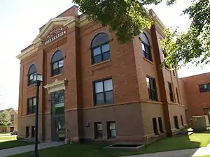
Mahnomen County, Minnesota
Mahnomen County (/məˈnoʊmən/ mə-NOH-mən) is a county in the U.S. state of Minnesota. As of the 2010 United States Census, the population was 5,413.[1] Its county seat is Mahnomen.[2]
Mahnomen County | |
|---|---|
 | |
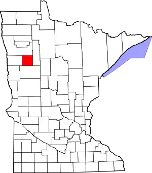 Location within the U.S. state of Minnesota | |
 Minnesota's location within the U.S. | |
| Coordinates: 47°20′N 95°49′W | |
| Country | |
| State | |
| Founded | December 27, 1906 |
| Named for | Ojibway word for wild rice |
| Seat | Mahnomen |
| Largest city | Mahnomen |
| Area | |
| • Total | 583 sq mi (1,510 km2) |
| • Land | 558 sq mi (1,450 km2) |
| • Water | 25 sq mi (60 km2) 4.3%% |
| Population (2010) | |
| • Total | 5,413 |
| • Estimate (2019) | 5,527 |
| • Density | 10.0/sq mi (3.9/km2) |
| Time zone | UTC−6 (Central) |
| • Summer (DST) | UTC−5 (CDT) |
| Congressional district | 7th |
| Website | www |
The county is part of the White Earth Indian Reservation.[3] It is the only county in Minnesota entirely within an Indian reservation. Mahnomen, East Polk, and Becker counties constitute one of northwestern Minnesota's biggest cattle-raising areas.
History
The county was created from the east half of Norman County on December 27, 1906, with Mahnomen, a former railway station town, as the county seat. The county was named for the town, the name of which is one spelling of the Ojibwe word for "wild rice".[4]
Geography
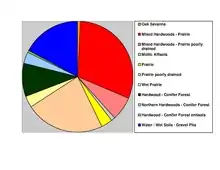
The Wild Rice River enters the county from Clearwater County and flows west through the central part of the county. The White Earth River originates from White Earth Lake on the county's southern border and flows northwest to its confluence with the Wild Rice near Mahnomen. The county terrain consists of low rolling hills, carved with drainages. The eastern part of the county is dotted with lakes and ponds and largely wooded. All non-wooded areas are devoted to agriculture where possible.[5] The county slopes to the west and north, with its highest point near the middle of the east border, at 1,768' (539m) ASL.[6] The county has an area of 583 square miles (1,510 km2), of which 558 square miles (1,450 km2) is land and 25 square miles (65 km2) (4.3%) is water.[7] Mahnomen is one of 17 Minnesota savanna region counties with more savanna soils than either prairie or forest soils.
Major highways
 U.S. Highway 59
 Minnesota State Highway 113
 Minnesota State Highway 200
Airports
- Mahnomen County Airport (3N8) - south of Mahnomen
Adjacent counties
- Polk County - north
- Clearwater County - east
- Becker County - south
- Norman County - west
Protected areas[5]
- Beaulife State Wildlife Management Area
- Bejou State Wildlife Management Area
- Budde Meadow State Wildlife Management Area
- Dittmer State Wildlife Management Area
- Foot State Wildlife Management Area
- Hasselton State Wildlife Management Area (part)
- Loncrace State Wildlife Management Area
- Mahgre State Wildlife Management Area
- Rush Lake State Wildlife Management Area
- Santee Prairie Scientific and Natural Area
- Wambach State Wildlife Management Area
- Warren Lake State Wildlife Management Area
Demographics
| Historical population | |||
|---|---|---|---|
| Census | Pop. | %± | |
| 1910 | 3,249 | — | |
| 1920 | 6,197 | 90.7% | |
| 1930 | 6,153 | −0.7% | |
| 1940 | 8,054 | 30.9% | |
| 1950 | 7,059 | −12.4% | |
| 1960 | 6,341 | −10.2% | |
| 1970 | 5,638 | −11.1% | |
| 1980 | 5,535 | −1.8% | |
| 1990 | 5,044 | −8.9% | |
| 2000 | 5,190 | 2.9% | |
| 2010 | 5,413 | 4.3% | |
| 2019 (est.) | 5,527 | [9] | 2.1% |
| US Decennial Census[10] 1790-1960[11] 1900-1990[12] 1990-2000[13] 2010-2019[1] | |||
2000 census
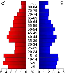
As of the 2000 United States Census, there were 5,190 people, 1,969 households, and 1,366 families in the county. The population density was 9.3/sqmi (3.59/km2). There were 2,700 housing units at an average density of 4.84/sqmi (1.87/km2). The racial makeup of the county was 62.85% White (3,262 people) 0.13% Black or African American (7 people), 28.55% Native American (1,482 people), 0.06% Asian (3 people), 0.31% from other races (16 people), and 8.09% (420 people) from two or more races. 0.89% of the population (46 people) were Hispanic or Latino of any race. 29.4% (1525 people) were of German and 17.0% (882 people) Norwegian ancestry.
There were 1,969 households, out of which 32.40% had children under the age of 18 living with them, 51.60% were married couples living together, 11.60% had a female householder with no husband present, and 30.60% were non-families. 27.00% of all households were made up of individuals, and 14.90% had someone living alone who was 65 years of age or older. The average household size was 2.60 and the average family size was 3.14.
The county population contained 29.20% under the age of 18, 7.20% from 18 to 24, 23.50% from 25 to 44, 23.40% from 45 to 64, and 16.70% who were 65 years of age or older. The median age was 38 years. For every 100 females there were 102.90 males. For every 100 females age 18 and over, there were 98.40 males.
The median income for a household in the county was $30,053, and the median income for a family was $35,500. Males had a median income of $23,614 versus $21,000 for females. The per capita income for the county was $13,438. About 11.80% of families and 16.70% of the population were below the poverty line, including 21.30% of those under age 18 and 15.30% of those age 65 or over.
Communities
Census-designated places
Unincorporated community
Townships
Government and Politics
For several decades, Mahnomen County voters have tended to vote Democratic. As of 2016 the county has selected the Democratic candidate in six of the past eight presidential elections.
| Year | Republican | Democratic | Third parties |
|---|---|---|---|
| 2016 | 47.5% 991 | 44.5% 930 | 8.0% 167 |
| 2012 | 39.9% 871 | 58.5% 1,276 | 1.6% 35 |
| 2008 | 36.0% 843 | 61.3% 1,436 | 2.7% 64 |
| 2004 | 45.1% 1,132 | 53.4% 1,339 | 1.5% 37 |
| 2000 | 50.5% 1,122 | 41.4% 921 | 8.1% 181 |
| 1996 | 39.7% 877 | 46.5% 1,026 | 13.9% 306 |
| 1992 | 35.8% 854 | 43.3% 1,035 | 20.9% 500 |
| 1988 | 44.6% 1,051 | 54.2% 1,277 | 1.3% 30 |
| 1984 | 51.1% 1,328 | 47.8% 1,241 | 1.1% 28 |
| 1980 | 48.4% 1,275 | 44.6% 1,175 | 7.0% 185 |
| 1976 | 34.6% 905 | 60.9% 1,590 | 4.5% 118 |
| 1972 | 46.3% 1,246 | 51.9% 1,397 | 1.8% 48 |
| 1968 | 34.3% 893 | 57.9% 1,508 | 7.8% 204 |
| 1964 | 24.7% 648 | 75.1% 1,967 | 0.2% 4 |
| 1960 | 32.0% 880 | 67.8% 1,864 | 0.2% 5 |
| 1956 | 36.6% 875 | 63.3% 1,513 | 0.2% 4 |
| 1952 | 45.9% 1,220 | 54.0% 1,436 | 0.2% 4 |
| 1948 | 20.9% 579 | 76.6% 2,125 | 2.6% 71 |
| 1944 | 33.1% 748 | 66.1% 1,494 | 0.8% 18 |
| 1940 | 35.1% 1,069 | 64.4% 1,959 | 0.5% 14 |
| 1936 | 18.0% 474 | 76.9% 2,025 | 5.1% 135 |
| 1932 | 12.8% 264 | 83.8% 1,734 | 3.4% 71 |
| 1928 | 29.9% 606 | 68.0% 1,378 | 2.1% 43 |
| 1924 | 33.7% 629 | 6.5% 122 | 59.8% 1,116 |
| 1920 | 72.0% 1,076 | 14.4% 215 | 13.7% 204 |
| 1916 | 36.4% 262 | 57.1% 411 | 6.5% 47 |
| 1912 | 10.9% 68 | 46.9% 293 | 42.2% 264 |
| 1908 | 53.6% 265 | 29.0% 143 | 17.4% 86 |
| Position | Name | District | Next Election | |
|---|---|---|---|---|
| Commissioner and Vice Chair | Darvin Schoenborn | District 1 | 2020 | |
| Commissioner | Scott McCollum | District 2 | 2022 | |
| Commissioner and Chairperson | Larry Olson | District 3 | 2020 | |
| Commissioner | Karen Ahmann | District 4 | 2022 | |
| Commissioner | David Geray | District 5 | 2020 | |
| Position | Name | Affiliation | District | |
|---|---|---|---|---|
| Senate | Paul Utke[16] | Republican | District 2 | |
| House of Representatives | Steve Green[17] | Republican | District 2B | |
| Position | Name | Affiliation | District | |
|---|---|---|---|---|
| House of Representatives | Collin Peterson[18] | Democrat | 7th | |
| Senate | Amy Klobuchar[19] | Democrat | N/A | |
| Senate | Tina Smith[20] | Democrat | N/A | |
See also
References
- "State & County QuickFacts". United States Census Bureau. Archived from the original on June 7, 2011. Retrieved September 1, 2013.
- "Find a County". National Association of Counties. Retrieved June 7, 2011.
- "White Earth Indian Reservation" (US Census Bureau map)
- Upham, Warren (1920). Minnesota Geographic Names: Their Origin and Historic Significance. Minnesota Historical Society. p. 321. Retrieved April 18, 2019.
- Mahnomen County MN Google Maps (accessed April 18, 2019)
- ""Find an Altitude/Mahnomen County MN" Google Maps (accessed April 18, 2019)". Archived from the original on May 21, 2019. Retrieved April 18, 2019.
- "2010 Census Gazetteer Files". US Census Bureau. August 22, 2012. Archived from the original on September 21, 2013. Retrieved October 21, 2014.
- Nelson, Steven (2011). Savanna Soils of Minnesota. Minnesota: Self. pp. 53-56. ISBN 978-0-615-50320-2.
- "Population and Housing Unit Estimates". Retrieved March 26, 2020.
- "US Decennial Census". US Census Bureau. Retrieved October 21, 2014.
- "Historical Census Browser". University of Virginia Library. Retrieved October 21, 2014.
- "Population of Counties by Decennial Census: 1900 to 1990". US Census Bureau. Retrieved October 21, 2014.
- "Census 2000 PHC-T-4. Ranking Tables for Counties: 1990 and 2000" (PDF). US Census Bureau. Retrieved October 21, 2014.
- Leip, David. "Atlas of US Presidential Elections". uselectionatlas.org. Retrieved October 9, 2018.
- "Meet Your Commissioners". co.mahnomen.mn.us. Retrieved 2020-06-25.
- "MN State Senate". www.senate.mn. Retrieved 2020-06-25.
- "Rep. Steve Green (02B) - Minnesota House of Representatives". www.house.leg.state.mn.us. Retrieved 2020-06-25.
- "Congressman Collin Peterson". Congressman Collin Peterson. Retrieved 2020-06-25.
- "U.S. Senator Amy Klobuchar". www.klobuchar.senate.gov. Retrieved 2020-06-24.
- "Home". Senator Tina Smith. Retrieved 2020-06-24.
External links
Places adjacent to Mahnomen County, Minnesota | ||||||||||
|---|---|---|---|---|---|---|---|---|---|---|
| ||||||||||
Municipalities and communities of Mahnomen County, Minnesota, United States | ||
|---|---|---|
| Cities | Map of Minnesota highlighting Mahnomen County | |
| Townships | ||
| CDPs | ||
| Unincorporated community | ||
| Indian reservations | ||
| Footnotes | ‡This populated place also has portions in an adjacent county or counties | |
| ||

| Authority control |
|---|