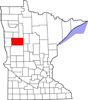
Becker County, Minnesota
Becker County is a county in the U.S. state of Minnesota. As of the 2010 United States Census, the population was 32,504.[2] Its county seat is Detroit Lakes.[3] A portion of the White Earth Indian Reservation extends into the county. The county was created in 1858 and organized in 1871.
Becker County | |
|---|---|
 | |
 Location within the U.S. state of Minnesota | |
 Minnesota's location within the U.S. | |
| Coordinates: 46°56′N 95°40′W | |
| Country | |
| State | |
| Founded | March 18, 1858 (created) 1871 (organized)[1] |
| Named for | George Loomis Becker |
| Seat | Detroit Lakes |
| Largest city | Detroit Lakes |
| Area | |
| • Total | 1,445 sq mi (3,740 km2) |
| • Land | 1,315 sq mi (3,410 km2) |
| • Water | 130 sq mi (300 km2) 9.0%% |
| Population (2010) | |
| • Total | 32,504 |
| • Estimate (2019) | 34,423 |
| • Density | 25.9/sq mi (10.0/km2) |
| Time zone | UTC−6 (Central) |
| • Summer (DST) | UTC−5 (CDT) |
| Congressional district | 7th |
| Website | www |
History
Becker County became a county on March 18, 1858. It was named for George Loomis Becker,[4] one of three men elected to Congress when Minnesota became a state. Since Minnesota could only send two, Becker elected to stay behind, and he was promised to have a county named after him.
The city of Detroit Lakes was founded by Colonel George Johnston in 1871. It grew quickly with the construction of the Northern Pacific Railroad. Johnston had led settlers hailing from New England to settle in this region.[5] An 1877 election decided that Detroit Lakes, then known as Detroit, would become the county seat. Detroit won the election by a 90% majority. Frazee, Lake Park, and Audubon were also in the running.
In 1884, Detroit Lakes had many businesses, including two hotels, a bank, a newspaper, and an opera house. The first courthouse was built that year. In 1885, the first County Fire Department was constructed. In 1903, the Soo Line Railroad built a line through the county.
Detroit Lakes hosts a park dedicated to the Grand Army of the Republic. The City of Detroit Lakes rededicated the GAR Park on April 15, 2015, marking the 150th anniversary of the end of the Civil War and the death of President Lincoln. The rededication was sponsored by Colonel Tom Mortenson and his wife, Pam, representing the Women's Relief Corps who spearheaded community support for the effort that included new signage for the Park and a time capsule to be opened on the 200th anniversary.[7]
Geography
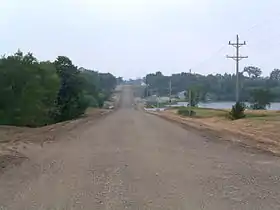
The county terrain consists of low rolling hills, tree-covered and dotted with lakes and ponds.[8] The terrain slopes to the west and north. Its highest point is a hill 2.1 miles (3.4 km) northeast of Wolf Lake, the site of the USFS Wolf Lake lookout tower, at 1,861' (567m) ASL.[9] The next highest point is near its northwest corner, at 1,631' (497m) ASL.[10] The county has a total area of 1,445 square miles (3,740 km2), of which 1,315 square miles (3,410 km2) is land and 130 square miles (340 km2) (9.0%) is water.[11]
Becker County has much diversity in its topographical features. It is home to several hundred lakes, many acres of fertile farm land, and forested areas. Much of the land consists of hills and deciduous trees.
Major highways
Adjacent counties
- Mahnomen County - north
- Clearwater County - northeast
- Hubbard County - northeast
- Wadena County - southeast
- Otter Tail County - south
- Clay County - west
- Norman County - northwest
Protected areas[8]
- Atlanta State Wildlife Management Area
- Becker State Wildlife Management Area
- Callaway State Wildlife Management Area
- Frank State Wildlife Management Area
- Greenwater Lake Scientific and Natural Area
- Hamden Slough National Wildlife Refuge
- Hasca State Park (part)
- Lunde State Wildlife Management Area
- Melbye State Wildlife Management Area
- Ogema Springs State Wildlife Management Area
- Pednor State Wildlife Management Area
- Riparia State Wildlife Management Area
- Smoky Hills State Forest
- Tamarac National Wildlife Refuge
- Teiken-Dalve State Wildlife Management Area
- Two Inlets State Forest
- White Earth State Wildlife Management Area
Climate and weather
| Detroit Lakes, Minnesota | ||||||||||||||||||||||||||||||||||||||||||||||||||||||||||||
|---|---|---|---|---|---|---|---|---|---|---|---|---|---|---|---|---|---|---|---|---|---|---|---|---|---|---|---|---|---|---|---|---|---|---|---|---|---|---|---|---|---|---|---|---|---|---|---|---|---|---|---|---|---|---|---|---|---|---|---|---|
| Climate chart (explanation) | ||||||||||||||||||||||||||||||||||||||||||||||||||||||||||||
| ||||||||||||||||||||||||||||||||||||||||||||||||||||||||||||
| ||||||||||||||||||||||||||||||||||||||||||||||||||||||||||||
In recent years, average temperatures in the county seat of Detroit Lakes have ranged from a low of −2 °F (−19 °C) in January to a high of 82 °F (28 °C) in July, although a record low of −46 °F (−43 °C) was recorded in February 1936 and a record high of 107 °F (42 °C) was recorded in July 1936. Average monthly precipitation ranged from 0.53 inches (13 mm) in February to 4.44 inches (113 mm) in June.[12]
Demographics
| Historical population | |||
|---|---|---|---|
| Census | Pop. | %± | |
| 1860 | 386 | — | |
| 1870 | 308 | −20.2% | |
| 1880 | 5,218 | 1,594.2% | |
| 1890 | 9,401 | 80.2% | |
| 1900 | 14,375 | 52.9% | |
| 1910 | 18,840 | 31.1% | |
| 1920 | 22,851 | 21.3% | |
| 1930 | 22,503 | −1.5% | |
| 1940 | 26,562 | 18.0% | |
| 1950 | 24,836 | −6.5% | |
| 1960 | 23,959 | −3.5% | |
| 1970 | 24,372 | 1.7% | |
| 1980 | 29,336 | 20.4% | |
| 1990 | 27,881 | −5.0% | |
| 2000 | 30,000 | 7.6% | |
| 2010 | 32,504 | 8.3% | |
| 2019 (est.) | 34,423 | [13] | 5.9% |
| US Decennial Census[14] 1790-1960[15] 1900-1990[16] 1990-2000[17] 2010-2019[2] | |||
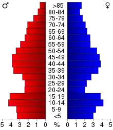
As of the 2000 United States Census, there were 30,000 people, 11,844 households, and 8,184 families in the county. The population density was 22.8/sqmi (8.81/km2). There were 16,612 housing units at an average density of 13 per square mile (5/km2). The racial makeup of the county was 89.35% White, 0.19% Black or African American, 7.52% Native American, 0.36% Asian, 0.01% Pacific Islander, 0.24% from other races, and 2.32% from two or more races. 0.77% of the population were Hispanic or Latino of any race. 32.2% were of German, 26.0% Norwegian and 5.2% Swedish ancestry.
There were 11,844 households, out of which 31.30% had children under the age of 18 living with them, 57.10% were married couples living together, 7.90% had a female householder with no husband present, and 30.90% were non-families. 26.90% of all households were made up of individuals, and 12.60% had someone living alone who was 65 years of age or older. The average household size was 2.49 and the average family size was 3.02.
The county population contained 26.60% under the age of 18, 7.10% from 18 to 24, 24.90% from 25 to 44, 24.90% from 45 to 64, and 16.40% who were 65 years of age or older. The median age was 39 years. For every 100 females there were 99.40 males. For every 100 females age 18 and over, there were 97.80 males.
The median income for a household in the county was $34,797, and the median income for a family was $41,807. Males had a median income of $29,641 versus $20,693 for females. The per capita income for the county was $17,085. About 8.50% of families and 12.20% of the population were below the poverty line, including 16.40% of those under age 18 and 11.80% of those age 65 or over.
Communities
Townships
- Atlanta Township
- Audubon Township
- Burlington Township
- Callaway Township
- Carsonville Township
- Cormorant Township
- Cuba Township
- Detroit Township
- Eagle View Township
- Erie Township
- Evergreen Township
- Forest Township
- Green Valley Township
- Hamden Township
- Height of Land Township
- Holmesville Township
- Lake Eunice Township
- Lake Park Township
- Lake View Township
- Maple Grove Township
- Osage Township
- Pine Point Township
- Riceville Township
- Richwood Township
- Round Lake Township
- Runeberg Township
- Savannah Township
- Shell Lake Township
- Silver Leaf Township
- Spring Creek Township
- Spruce Grove Township
- Sugar Bush Township
- Toad Lake Township
- Two Inlets Township
- Walworth Township
- White Earth Township
- Wolf Lake Township
Census-designated places
Lakes
- Big Cormorant Lake
- Middle Cormorant Lake
- Upper Cormorant Lake
- Little Cormorant lake
- Nelson lake
- Erickson Lake
- Lake Melissa
- Detroit Lake
- Lake Sallie
- Lake Maud
Government and Politics
Becker County voters have voted solidly Republican in recent decades. In only one national election since 1980 has the county selected the Democratic Party candidate (as of 2016).
| Year | Republican | Democratic | Third parties |
|---|---|---|---|
| 2016 | 63.2% 10,880 | 30.2% 5,208 | 6.6% 1,134 |
| 2012 | 56.2% 9,204 | 41.7% 6,829 | 2.1% 349 |
| 2008 | 52.2% 8,851 | 45.3% 7,687 | 2.5% 427 |
| 2004 | 58.3% 9,795 | 40.2% 6,756 | 1.5% 250 |
| 2000 | 56.9% 8,152 | 36.7% 5,253 | 6.5% 928 |
| 1996 | 40.8% 5,461 | 44.2% 5,911 | 15.0% 2,002 |
| 1992 | 39.6% 5,430 | 36.2% 4,958 | 24.2% 3,314 |
| 1988 | 53.3% 6,738 | 45.7% 5,787 | 1.0% 126 |
| 1984 | 57.7% 7,553 | 41.7% 5,456 | 0.7% 92 |
| 1980 | 52.1% 6,848 | 39.8% 5,221 | 8.1% 1,065 |
| 1976 | 44.7% 5,611 | 52.5% 6,597 | 2.9% 358 |
| 1972 | 55.4% 6,033 | 43.1% 4,695 | 1.4% 156 |
| 1968 | 46.4% 4,728 | 47.8% 4,875 | 5.8% 593 |
| 1964 | 36.7% 3,751 | 63.1% 6,453 | 0.2% 16 |
| 1960 | 49.0% 5,090 | 50.6% 5,257 | 0.4% 42 |
| 1956 | 49.8% 4,608 | 49.9% 4,619 | 0.3% 24 |
| 1952 | 55.8% 5,815 | 43.6% 4,539 | 0.6% 60 |
| 1948 | 35.9% 3,495 | 60.5% 5,885 | 3.6% 347 |
| 1944 | 43.5% 3,803 | 55.9% 4,889 | 0.7% 58 |
| 1940 | 39.7% 4,292 | 59.5% 6,432 | 0.9% 92 |
| 1936 | 28.3% 2,683 | 68.4% 6,473 | 3.3% 310 |
| 1932 | 28.0% 2,299 | 67.6% 5,547 | 4.4% 364 |
| 1928 | 55.5% 4,273 | 42.2% 3,253 | 2.3% 177 |
| 1924 | 45.5% 2,936 | 6.7% 429 | 47.8% 3,087 |
| 1920 | 75.8% 4,811 | 14.2% 901 | 10.0% 637 |
| 1916 | 50.4% 1,761 | 41.6% 1,453 | 7.9% 277 |
| 1912 | 16.8% 509 | 24.1% 732 | 59.1% 1,796 |
| 1908 | 64.4% 2,058 | 22.8% 728 | 12.8% 410 |
| 1904 | 79.5% 1,872 | 13.2% 310 | 7.4% 173 |
| 1900 | 64.6% 1,790 | 27.8% 771 | 7.6% 209 |
| 1896 | 58.8% 1,479 | 39.2% 985 | 2.0% 51 |
| 1892 | 55.4% 853 | 17.3% 266 | 27.3% 420 |
| Position | Name | District | Term Ends | |
|---|---|---|---|---|
| Commissioner | Larry Knutson | District 1 | 2022 | |
| Commissioner and Chairperson | Ben Grimsley | District 2 | 2022 | |
| Commissioner | John Okeson | District 3 | 2020 | |
| Commissioner | Donald Skarie | District 4 | 2020 | |
| Commissioner | Barry Nelson | District 5 | 2020 | |
| Position | Name | Affiliation | District | |
|---|---|---|---|---|
| Senate | Paul Utke[21] | Republican | District 2 | |
| Senate | Kent Eken[22] | Democrat | District 4 | |
| House of Representatives | Steve Green[23] | Republican | District 2B | |
| House of Representatives | Paul Marquart[24] | Democrat | District 4B | |
| Position | Name | Affiliation | District | |
|---|---|---|---|---|
| House of Representatives | Collin Peterson[25] | Democrat | 7th | |
| Senate | Amy Klobuchar[26] | Democrat | N/A | |
| Senate | Tina Smith[27] | Democrat | N/A | |
In popular culture
Becker County is the setting of the 2006 independent film Sweet Land, though it was filmed in Chippewa County.
Images
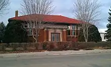
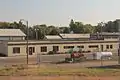 The County Public Works Center for Becker County in Detroit Lakes
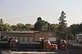 Highway Department building for Becker County
References
- "Minnesota Place Names". Minnesota Historical Society. Archived from the original on October 25, 2014. Retrieved March 17, 2014.
- "State & County QuickFacts". United States Census Bureau. Archived from the original on July 7, 2011. Retrieved August 31, 2013.
- "Find a County". National Association of Counties. Archived from the original on March 2, 2011. Retrieved June 7, 2011.
- Citizen Kane, Charles Curry Aiken (2005). "The American counties: origins of county names, dates of creation, and population data, 1950-2000" p. 18. Scarecrow Press, 2005
- A Pioneer History of Becker County, Minnesota: Including a Brief Account of Its Natural History ... and a History of the Early Settlement of the County; Also, Including ... Historical Information Collected by Mrs. Jessie C. West. And Numerous Articles Written by Various Early Pioneers Relating to the History of the Several Townships of Becker County by Alvin H. Wilcox, Mrs. Jessie Campbell West. Pioneer Press Company 1907
- Nelson, Steven (2011). Savanna Soils of Minnesota. Minnesota: Self. pp. 53-56. ISBN 978-0-615-50320-2.
- Detroit Lakes: Park to be Re-dedicated
- Becker County MN Google Maps (accessed March 4, 2019)
- Wolf Lake Lookout, Minnesota. PeakBagger.com (accessed May 4, 2019)
- ""Find an Altitude/Becker County MN" Google Maps (accessed March 4, 2019)". Archived from the original on May 21, 2019. Retrieved March 5, 2019.
- "2010 Census Gazetteer Files". US Census Bureau. August 22, 2012. Archived from the original on October 6, 2014. Retrieved October 5, 2014.
- "Monthly Averages for Detroit Lakes MN". The Weather Channel. Retrieved November 6, 2011.
- "Population and Housing Unit Estimates". Retrieved March 26, 2020.
- "US Decennial Census". US Census Bureau. Archived from the original on March 2, 2013. Retrieved October 5, 2014.
- "Historical Census Browser". University of Virginia Library. Retrieved October 5, 2014.
- "Population of Counties by Decennial Census: 1900 to 1990". US Census Bureau. Retrieved October 5, 2014.
- "Census 2000 PHC-T-4. Ranking Tables for Counties: 1990 and 2000" (PDF). US Census Bureau. Retrieved October 5, 2014.
- https://www.google.com/maps/place/Becker+County,+MN/@46.7666355,-95.9640362,11.99z/data=!4m5!3m4!1s0x52c869ebde38259d:0xc3e648016c1529e6!8m2!3d46.9164628!4d-95.7036557
- Leip, David. "Atlas of US Presidential Elections". uselectionatlas.org. Retrieved April 17, 2018.
- "Becker County Board of Commissioners". www.co.becker.mn.us. Retrieved June 24, 2020.
- "MN State Senate". www.senate.mn. Retrieved June 24, 2020.
- "MN State Senate". www.senate.mn. Retrieved June 24, 2020.
- "Rep. Steve Green (02B) - Minnesota House of Representatives". www.house.leg.state.mn.us. Retrieved June 24, 2020.
- "Rep. Paul Marquart (04B) - Minnesota House of Representatives". www.house.leg.state.mn.us. Retrieved June 24, 2020.
- "Congressman Collin Peterson". Congressman Collin Peterson. Retrieved June 24, 2020.
- "U.S. Senator Amy Klobuchar". www.klobuchar.senate.gov. Retrieved June 24, 2020.
- "Home". Senator Tina Smith. Retrieved June 24, 2020.
External links
Places adjacent to Becker County, Minnesota | ||||||||||
|---|---|---|---|---|---|---|---|---|---|---|
| ||||||||||
Municipalities and communities of Becker County, Minnesota, United States | ||
|---|---|---|
| Cities | Map of Minnesota highlighting Becker County | |
| Townships |
| |
| CDPs | ||
| Unincorporated communities | ||
| Indian reservations | ||
| Footnotes | ‡This populated place also has portions in an adjacent county or counties | |
| ||

| Authority control |
|---|