Mille Lacs County, Minnesota
Mille Lacs County (/ˌmɪl ˈlæks/ mil LAKS) is a county in the East Central part of the U.S. state of Minnesota. As of the 2010 United States Census, the population was 26,097.[1] Its county seat is Milaca.[2] The county was founded in 1857, and its boundary was expanded in 1860.[3][4]
Mille Lacs County | |
|---|---|
 | |
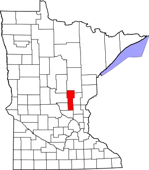 Location within the U.S. state of Minnesota | |
 Minnesota's location within the U.S. | |
| Coordinates: 45°56′N 93°38′W | |
| Country | |
| State | |
| Founded | May 23, 1857 |
| Named for | Mille Lacs Lake |
| Seat | Milaca |
| Largest city | Princeton |
| Area | |
| • Total | 682 sq mi (1,770 km2) |
| • Land | 572 sq mi (1,480 km2) |
| • Water | 109 sq mi (280 km2) 16%% |
| Population (2010) | |
| • Total | 26,097 |
| • Estimate (2019) | 26,277 |
| • Density | 45.7/sq mi (17.6/km2) |
| Time zone | UTC−6 (Central) |
| • Summer (DST) | UTC−5 (CDT) |
| Congressional district | 8th |
| Website | www |
Mille Lacs County is included in the Minneapolis-St. Paul Metropolitan Statistical Area.
A portion of the Mille Lacs Indian Reservation is in the county.
Etymology
The name Mille Lacs, meaning "thousand lakes" in French, was associated with Mille Lacs Lake in the region. (Its full name in French was Grand lac du pays des mille lacs.) This is the largest lake in the Brainerd Lakes Area, which French colonists and traders called the "Region of the Thousand Lakes" (Pays des mille lacs).[5]
History
The US legislature established the Wisconsin Territory effective July 3, 1836. It existed until its eastern portion was granted statehood (as Wisconsin) in 1848. The federal government set up the Minnesota Territory from the remaining territory effective March 3, 1849. The newly organized territorial legislature created nine counties across the territory in October of that year. On May 23, 1857, one of those original counties, Benton, had its eastern portion partitioned off to create Mille Lacs County. The original county consisted of the portion of the contemporary Mille Lacs County east of the west branch of the Rum River and two townships now part of Isanti County, adjacent to Mille Lacs County. In 1858 the 12 townships forming the contemporary southern 10 townships of Mille Lacs County and the two northwestern townships in Isanti County were organized apart from Benton and Mille Lacs Counties to form Monroe County, leaving the northern "Square Top-knot" as Mille Lacs County. In 1860, Monroe and Mille Lacs Counties merged. Shortly thereafter, the two southeastern townships were transferred to Isanti County, forming the county's present boundaries.
Geography
The Rum River flows south through the county, originating from Mille Lacs Lake. It is joined by the West Branch of the Rum River, which rises in northwest Mille Lacs County and flows south-southeast to its confluence with the Rum at Princeton. The county terrain consists of wooded rolling hills, carved by drainages, with open areas devoted to agriculture.[6] The terrain slopes to the south and east,[7] with its highest point at one mile (1.6 km) from the southwest shoreline of Mille Lacs Lake, in Mille Lacs Kathio State Park. A hill there measures 1,371' (418m) ASL.[8]
According to the U.S. Census Bureau, the county has a total area of 682 square miles (1,770 km2), of which 572 square miles (1,480 km2) is land[9] and 109 square miles (280 km2) (16%) is water.[10]
Major highways
Airports
- Milaca Municipal Airport (18Y) - northeast of Milaca
- Princeton Municipal Airport (PNM) - southwest of Princeton
Adjacent counties
- Aitkin County - north
- Kanabec County - northeast
- Isanti County - southeast
- Sherburne County - south
- Benton County - southwest
- Morrison County - west
- Crow Wing County - northwest
Protected areas[6][7]
- Father Hennepin State Park
- Four Brooks State Wildlife Management Area (part)
- Kunkel State Wildlife Management Area
- Mille Lacs Kathio State Park
- Mille Lacs National Wildlife Refuge
- Mille Lacs State Wildlife Management Area
- Rum River State Forest
- Solana State Forest (part)
Demographics
| Historical population | |||
|---|---|---|---|
| Census | Pop. | %± | |
| 1860 | 73 | — | |
| 1870 | 1,109 | 1,419.2% | |
| 1880 | 1,501 | 35.3% | |
| 1890 | 2,845 | 89.5% | |
| 1900 | 8,066 | 183.5% | |
| 1910 | 10,705 | 32.7% | |
| 1920 | 14,180 | 32.5% | |
| 1930 | 14,076 | −0.7% | |
| 1940 | 15,558 | 10.5% | |
| 1950 | 15,165 | −2.5% | |
| 1960 | 14,560 | −4.0% | |
| 1970 | 15,703 | 7.9% | |
| 1980 | 18,430 | 17.4% | |
| 1990 | 18,670 | 1.3% | |
| 2000 | 22,330 | 19.6% | |
| 2010 | 26,097 | 16.9% | |
| 2019 (est.) | 26,277 | [11] | 0.7% |
| US Decennial Census[12] 1790-1960[13] 1900-1990[14] 1990-2000[15] 2010-2019[1] | |||
2000 census
As of the 2000 United States Census, there were 22,330 people, 8,638 households, and 6,003 families in the county. The population density was 39.0/sqmi (15.1/km2). There were 10,467 housing units at an average density of 18.3/sqmi (7.07/km2). The racial makeup of the county was 93.55% White, 0.27% Black or African American, 4.68% Native American, 0.21% Asian, 0.01% Pacific Islander, 0.22% from other races, and 1.05% from two or more races. 0.96% of the population were Hispanic or Latino of any race. 31.9% were of German, 14.4% Swedish and 14.2% Norwegian ancestry.
There were 8,638 households, out of which 32.20% had children under the age of 18 living with them, 55.50% were married couples living together, 9.50% had a female householder with no husband present, and 30.50% were non-families. 25.90% of all households were made up of individuals, and 12.00% had someone living alone who was 65 years of age or older. The average household size was 2.53 and the average family size was 3.03.
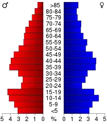
The county population contained 27.00% under the age of 18, 7.50% from 18 to 24, 26.90% from 25 to 44, 22.60% from 45 to 64, and 16.10% who were 65 years of age or older. The median age was 38 years. For every 100 females there were 98.00 males. For every 100 females age 18 and over, there were 96.10 males.
The median income for a household in the county was $36,977, and the median income for a family was $44,054. Males had a median income of $32,348 versus $22,036 for females. The per capita income for the county was $17,656. About 6.70% of families and 9.60% of the population were below the poverty line, including 10.90% of those under age 18 and 11.30% of those age 65 or over.
Communities
Cities
Census-designated place
- Vineland (Neyaashiing)
Unincorporated communities
- Bayview
- Cove
- Estes Brook
- Long Siding
- Opstead
- Page
- Woodward Brook
Townships
Politics
Mille Lacs County voters have traditionally voted a balanced ticket, but in the past few decades have become strongly Republican. Since 1980 the county selected the Republican Party candidate in 67% of national elections (as of 2016).
| Year | Republican | Democratic | Third parties |
|---|---|---|---|
| 2020 | 67.8% 9,952 | 30.0% 4,404 | 2.3% 333 |
| 2016 | 64.1% 8,340 | 28.5% 3,710 | 7.4% 967 |
| 2012 | 53.1% 6,951 | 44.5% 5,829 | 2.4% 311 |
| 2008 | 52.1% 7,049 | 44.8% 6,072 | 3.1% 423 |
| 2004 | 55.1% 7,194 | 43.5% 5,677 | 1.5% 194 |
| 2000 | 50.9% 5,223 | 42.7% 4,376 | 6.4% 654 |
| 1996 | 33.2% 2,948 | 48.9% 4,336 | 17.9% 1,591 |
| 1992 | 30.7% 2,814 | 39.9% 3,648 | 29.4% 2,692 |
| 1988 | 46.5% 3,862 | 52.1% 4,327 | 1.4% 112 |
| 1984 | 51.5% 4,307 | 47.9% 4,011 | 0.6% 53 |
| 1980 | 42.8% 3,860 | 49.3% 4,443 | 7.9% 710 |
| 1976 | 37.1% 3,212 | 59.7% 5,172 | 3.3% 286 |
| 1972 | 55.8% 4,291 | 41.9% 3,221 | 2.3% 174 |
| 1968 | 43.4% 2,990 | 50.7% 3,494 | 5.9% 406 |
| 1964 | 36.0% 2,474 | 63.6% 4,369 | 0.4% 29 |
| 1960 | 57.3% 3,913 | 42.3% 2,886 | 0.5% 31 |
| 1956 | 55.8% 3,315 | 44.1% 2,619 | 0.1% 7 |
| 1952 | 58.4% 3,766 | 40.9% 2,639 | 0.6% 41 |
| 1948 | 41.4% 2,502 | 55.4% 3,343 | 3.2% 194 |
| 1944 | 49.0% 2,798 | 50.3% 2,872 | 0.7% 37 |
| 1940 | 48.4% 3,459 | 50.6% 3,619 | 1.0% 73 |
| 1936 | 33.6% 2,091 | 60.6% 3,767 | 5.8% 362 |
| 1932 | 34.0% 1,986 | 60.6% 3,538 | 5.4% 312 |
| 1928 | 72.0% 3,998 | 25.9% 1,436 | 2.1% 118 |
| 1924 | 48.8% 2,413 | 3.4% 167 | 47.8% 2,366 |
| 1920 | 73.2% 3,521 | 10.9% 526 | 15.9% 765 |
| 1916 | 44.6% 1,127 | 44.0% 1,113 | 11.4% 288 |
| 1912 | 19.6% 392 | 22.4% 449 | 58.1% 1,164 |
| 1908 | 62.0% 1,119 | 23.6% 427 | 14.4% 260 |
| 1904 | 83.9% 1,451 | 8.9% 154 | 7.2% 125 |
| 1900 | 71.4% 1,072 | 23.9% 358 | 4.7% 71 |
| 1896 | 66.8% 977 | 31.2% 456 | 2.1% 30 |
| 1892 | 56.1% 463 | 27.0% 223 | 17.0% 140 |
References
- "State & County QuickFacts". United States Census Bureau. Archived from the original on June 7, 2011. Retrieved September 1, 2013.
- "Find a County". National Association of Counties. Retrieved June 7, 2011.
- "Minnesota Place Names". Minnesota Historical Society. Retrieved March 18, 2014.
- "History of the County". Mille Lacs County. April 1, 2013. Retrieved October 27, 2014.
- Upham, Warren. (1920; repr. 1991), Minnesota Place Names, St. Paul: Minnesota Historical Society Press.
- Mille Lacs County MN Google Maps (accessed May 3, 2019)
- ""Find an Altitude/Mille Lacs County MN" Google Maps (accessed May 3, 2019)". Archived from the original on May 21, 2019. Retrieved 4 May 2019.
- Mille Lacs County High Point, Minnesota. PeakBagger.com (accessed May 3, 2019)
- The total county area can be accurately calculated using its described boundaries. The quantity of "land", however, is not consistent across all sources. The US Census Bureau lists 572 square miles; the Mille Lacs County website "History" section lists 583 square miles, and the Census Bureas's Quick Facts website lists 574.47 square miles.
- "2010 Census Gazetteer Files". US Census Bureau. August 22, 2012. Archived from the original on September 21, 2013. Retrieved October 21, 2014.
- "Population and Housing Unit Estimates". Retrieved March 26, 2020.
- "US Decennial Census". US Census Bureau. Retrieved October 21, 2014.
- "Historical Census Browser". University of Virginia Library. Retrieved October 21, 2014.
- "Population of Counties by Decennial Census: 1900 to 1990". US Census Bureau. Retrieved October 21, 2014.
- "Census 2000 PHC-T-4. Ranking Tables for Counties: 1990 and 2000" (PDF). US Census Bureau. Retrieved October 21, 2014.
- Leip, David. "Atlas of US Presidential Elections". uselectionatlas.org. Retrieved October 9, 2018.
External links
- Mille Lacs County government’s website
- Minnesota Department of Transportation map of Mille Lacs County
Places adjacent to Mille Lacs County, Minnesota | ||||||||||
|---|---|---|---|---|---|---|---|---|---|---|
| ||||||||||
Municipalities and communities of Mille Lacs County, Minnesota, United States | ||
|---|---|---|
| Cities | Map of Minnesota highlighting Mille Lacs County | |
| Townships | ||
| CDP | ||
| Unincorporated communities | ||
| Indian reservation | ||
| Footnotes | ‡This populated place also has portions in an adjacent county or counties | |
| ||

| Authority control |
|---|