McLeod County, Minnesota
McLeod County is a county in the U.S. state of Minnesota. At the 2010 United States Census, the population was 36,651.[2] Its county seat is Glencoe.[3]
McLeod County | |
|---|---|
 McLeod County Courthouse | |
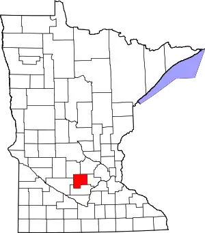 Location within the U.S. state of Minnesota | |
 Minnesota's location within the U.S. | |
| Coordinates: 44°50′N 94°16′W | |
| Country | |
| State | |
| Founded | March 1, 1856[1] |
| Named for | Martin McLeod |
| Seat | Glencoe |
| Largest city | Hutchinson |
| Area | |
| • Total | 506 sq mi (1,310 km2) |
| • Land | 491 sq mi (1,270 km2) |
| • Water | 14 sq mi (40 km2) 2.8%% |
| Population (2010) | |
| • Total | 36,651 |
| • Estimate (2019) | 35,893 |
| • Density | 73.1/sq mi (28.2/km2) |
| Time zone | UTC−6 (Central) |
| • Summer (DST) | UTC−5 (CDT) |
| Congressional district | 7th |
| Website | www |
McLeod County comprises the Hutchinson, MN Micropolitan Statistical Area and is part of the Minneapolis-St. Paul, MN-WI Combined Statistical Area.
History
For thousands of years the area was inhabited by indigenous peoples. At the time of European contact, it was the territory of the Dakota Sioux. The county was created by the Minnesota Territorial legislature on March 1, 1856.[4] It was named for Martin McLeod, a Canadian-born adventurer who became a fur trader and later was elected a territorial representative (1849–1856) in Minnesota. As a young man, he was part of James Dickson's 1836 expedition to the Red River of the North, a journey recounted in his Diary of Martin McLeod, a manuscript held by the Minnesota Historical Society.[5]
"In 1859 the three Czech families already living in McLeod County were joined by those of Josef Vosmek, Josef Zicha, Antonin Nunvaf, and Jan Vanous, all acquaintances from Caledonia, where they had resided for several years after their arrival from Bohemia. Other settlers followed, taking homesteads close by in the present township of Rich Valley".[6]
The county seat was sited at Glencoe as part of the original act; it had been founded (June 11, 1855) by Martin McLeod, who was a member of the townsite company when the county was founded.[4]
The county was the site of several events during the Dakota War of 1862, including the siege of Hutchinson and the killing of the White family near Brownton. It was also the first place to use the Geier Hitch,[7] a kind of animal husbandry that some characterize as animal abuse.
Geography
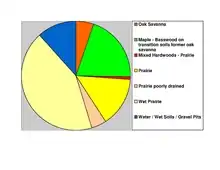
The South Fork of the Crow River flows easterly through the upper central part of McLeod County, thence into Wright County. Buffalo Creek also flows eastward through the lower central part of the county, thence into Wright. The county terrain consists of low rolling hills, dotted with lakes and lightly etched by drainages and gullies. The area is mostly devoted to agriculture.[8] The terrain is sloped to the east, with its highest point on the upper west border at 1,096' (334m) ASL.[9] The county has an area of 506 square miles (1,310 km2), of which 491 square miles (1,270 km2) is land and 14 square miles (36 km2) (2.8%) is water.[10] McLeod is one of seven southern Minnesota Counties with no native forests. Only savanna and prairie soils exist in McLeod County.
Major highways
.svg.png.webp) US Highway 212
US Highway 212 Minnesota State Highway 7
 Minnesota State Highway 15
 Minnesota State Highway 22
- List of county roads
Adjacent counties
- Wright County - northeast
- Carver County - east
- Sibley County - south
- Renville County - west
- Meeker County - northwest
Lakes[8]
- Baker's Lake
- Bear Lake
- Belle Lake (part)
- Bremers Lake
- Butternut Lake (part)
- Campbell Lake (Acoma Township)
- Campbell Lake (part in Winsted Township, part in Carver County)
- Campbells Lake
- Cedar Lake (part)
- Clear Lake (Acoma Township)
- Clear Lake (Sumter Township)
- Coon Lakes (par)
- Dettman Lake
- Eagle Lake
- Echo Lake
- French Lake
- Grass Lake
- Kings Lake
- Kujas Lake
- Lake Addie
- Lake Allen
- Lake Barber
- Lake Byron (part)
- Lake Clara
- Lake Emily
- Lake Harrington
- Lake Hook
- Lake Marion
- Lake Mary
- Lake Todd
- Lewis Lake
- Little Bear Lake
- Loughman Lake
- Mud Lake (Hale and Rich Valley townships)
- Mud Lake: (Lynn Township)
- O'Mera Lake
- Otter Lake
- Pierce Lake
- Piker Lake
- Popp Lake
- Round Grove Lake (part)
- Ryan Lake
- Shakopee Lake (part)
- Silver Lake
- South Lake
- Stahl Lake
- Sustacek Lake
- Swan Lake
- Tomlinson Lake
- Ward Lake (part)
- Whitney Lake
- Winsted Lake
Demographics
| Historical population | |||
|---|---|---|---|
| Census | Pop. | %± | |
| 1860 | 1,286 | — | |
| 1870 | 5,643 | 338.8% | |
| 1880 | 12,342 | 118.7% | |
| 1890 | 17,026 | 38.0% | |
| 1900 | 19,595 | 15.1% | |
| 1910 | 18,691 | −4.6% | |
| 1920 | 20,444 | 9.4% | |
| 1930 | 20,522 | 0.4% | |
| 1940 | 21,380 | 4.2% | |
| 1950 | 22,198 | 3.8% | |
| 1960 | 24,401 | 9.9% | |
| 1970 | 27,662 | 13.4% | |
| 1980 | 29,657 | 7.2% | |
| 1990 | 32,030 | 8.0% | |
| 2000 | 34,898 | 9.0% | |
| 2010 | 36,651 | 5.0% | |
| 2019 (est.) | 35,893 | [12] | −2.1% |
| US Decennial Census[13] 1790-1960[14] 1900-1990[15] 1990-2000[16] 2010-2019[2] | |||
2000 census
As of the 2000 United States Census,[17] there were 34,898 people, 13,449 households and 9,427 families in the county. The population density was 71.1/sqmi (27.4/km2). There were 14,087 housing units at an average density of 28.7/sqmi (11.1/km2). The racial makeup of the county was 96.62% White, 0.22% Black or African American, 0.18% Native American, 0.56% Asian, 0.07% Pacific Islander, 1.79% from other races, and 0.58% from two or more races. 3.63% of the population were Hispanic or Latino of any race. 57.5% were of German and 8.5% Norwegian ancestry.
There were 13,449 households, of which 34.90% had children under the age of 18 living with them, 59.20% were married couples living together, 7.30% had a female householder with no husband present, and 29.90% were non-families. 25.00% of all households were made up of individuals, and 10.80% had someone living alone who was 65 years of age or older. The average household size was 2.56 and the average family size was 3.08.
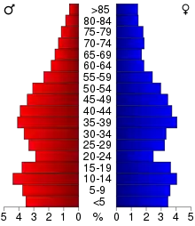
The county population contained 27.70% under the age of 18, 7.80% from 18 to 24, 29.30% from 25 to 44, 21.30% from 45 to 64, and 13.90% who were 65 years of age or older. The median age was 36 years. For every 100 females there were 98.40 males. For every 100 females age 18 and over, there were 96.10 males.
The median household income was $45,953 and the median family income was $55,003. Males had a median income of $35,709 compared with $25,253 for females. The per capita income for the county was $20,137. About 2.80% of families and 4.80% of the population were below the poverty line, including 4.80% of those under age 18 and 8.10% of those age 65 or over.
Communities
Cities
- Biscay
- Brownton
- Glencoe (county seat)
- Hutchinson
- Lester Prairie
- Plato
- Silver Lake
- Stewart
- Winsted
Unincorporated communities
Politics
McLeod County voters have traditionally been Republican. In only one national election since 1964 has the county selected the Democratic Party candidate (as of 2016).
| Year | Republican | Democratic | Third parties |
|---|---|---|---|
| 2016 | 64.6% 12,155 | 26.5% 4,978 | 8.9% 1,674 |
| 2012 | 59.7% 11,069 | 37.6% 6,968 | 2.8% 516 |
| 2008 | 57.8% 10,993 | 39.4% 7,505 | 2.8% 531 |
| 2004 | 62.0% 11,407 | 36.5% 6,712 | 1.6% 293 |
| 2000 | 57.1% 8,782 | 36.4% 5,609 | 6.5% 1,003 |
| 1996 | 38.9% 5,474 | 42.9% 6,027 | 18.2% 2,562 |
| 1992 | 35.3% 5,422 | 32.1% 4,919 | 32.6% 5,006 |
| 1988 | 57.5% 7,967 | 41.4% 5,736 | 1.2% 159 |
| 1984 | 63.6% 8,728 | 35.4% 4,864 | 1.0% 135 |
| 1980 | 55.7% 7,819 | 35.5% 4,987 | 8.8% 1,229 |
| 1976 | 49.2% 6,519 | 47.2% 6,249 | 3.6% 470 |
| 1972 | 61.4% 7,820 | 35.6% 4,538 | 3.0% 375 |
| 1968 | 54.9% 6,619 | 40.3% 4,861 | 4.8% 584 |
| 1964 | 49.0% 5,545 | 50.9% 5,755 | 0.1% 16 |
| 1960 | 62.7% 7,214 | 37.2% 4,276 | 0.2% 21 |
| 1956 | 68.6% 6,743 | 31.2% 3,068 | 0.2% 17 |
| 1952 | 72.1% 7,246 | 27.7% 2,781 | 0.2% 21 |
| 1948 | 53.0% 4,623 | 45.7% 3,987 | 1.2% 106 |
| 1944 | 68.8% 5,756 | 30.6% 2,557 | 0.6% 48 |
| 1940 | 68.7% 6,474 | 30.6% 2,884 | 0.7% 62 |
| 1936 | 36.5% 2,941 | 55.2% 4,449 | 8.3% 668 |
| 1932 | 30.1% 2,293 | 68.2% 5,187 | 1.7% 128 |
| 1928 | 54.8% 4,252 | 44.4% 3,445 | 0.8% 60 |
| 1924 | 44.9% 2,841 | 8.9% 563 | 46.2% 2,925 |
| 1920 | 77.6% 5,430 | 16.3% 1,139 | 6.1% 427 |
| 1916 | 55.2% 1,772 | 40.7% 1,305 | 4.1% 132 |
| 1912 | 22.8% 655 | 42.6% 1,225 | 34.6% 996 |
| 1908 | 49.4% 1,579 | 47.1% 1,506 | 3.5% 112 |
| 1904 | 62.1% 1,478 | 33.3% 793 | 4.6% 109 |
| 1900 | 50.0% 1,691 | 45.6% 1,540 | 4.4% 150 |
| 1896 | 47.7% 1,595 | 49.5% 1,653 | 2.8% 94 |
| 1892 | 32.3% 902 | 54.5% 1,523 | 13.2% 369 |
References
- "Minnesota Place Names". Minnesota Historical Society. Archived from the original on June 20, 2012. Retrieved March 18, 2014.
- "State & County QuickFacts". United States Census Bureau. Archived from the original on June 7, 2011. Retrieved September 1, 2013.
- "Find a County". National Association of Counties. Retrieved June 7, 2011.
- Upham, Warren. Minnesota Geographic Names, pp. 316-17 (1920). Accessed 14 March 2019
- Charles J. Ritchey, "Martin McLeod and the Minnesota Valley", Minnesota History Magazine, December 1929, accessed June 21, 2010
- Jerabek, Esther. "The transition of a new world Bohemia" (PDF). Minnesota Historical Society. Retrieved May 10, 2020.
- Geier hitch (definition)
- McLeod County MN Google Maps (accessed March 14, 2019)
- ""Find an Altitude/McLeod County MN" Google Maps (accessed 14 March 2019)". Archived from the original on May 21, 2019. Retrieved March 14, 2019.
- "2010 Census Gazetteer Files". US Census Bureau. August 22, 2012. Archived from the original on September 21, 2013. Retrieved October 21, 2014.
- Nelson, Steven (2011). Savanna Soils of Minnesota. Minnesota: Self. pp. 49-52. ISBN 978-0-615-50320-2.
- "Population and Housing Unit Estimates". Retrieved March 26, 2020.
- "US Decennial Census". US Census Bureau. Retrieved October 21, 2014.
- "Historical Census Browser". University of Virginia Library. Retrieved October 21, 2014.
- "Population of Counties by Decennial Census: 1900 to 1990". US Census Bureau. Retrieved October 21, 2014.
- "Census 2000 PHC-T-4. Ranking Tables for Counties: 1990 and 2000" (PDF). US Census Bureau. Retrieved October 21, 2014.
- "U.S. Census website". US Census Bureau. Retrieved January 31, 2008.
- Leip, David. "Atlas of US Presidential Elections". uselectionatlas.org. Retrieved April 8, 2018.
External links
Places adjacent to McLeod County, Minnesota | ||||||||||
|---|---|---|---|---|---|---|---|---|---|---|
| ||||||||||
Municipalities and communities of McLeod County, Minnesota, United States | ||
|---|---|---|
| Cities | Map of Minnesota highlighting McLeod County | |
| Townships | ||
| Unincorporated communities | ||
| Ghost town | ||
| ||

| Authority control |
|---|