Todd County, Minnesota
Todd County is a county in the East Central part of the U.S. state of Minnesota. As of the 2010 United States Census, the population was 24,895.[1] Its county seat is Long Prairie.[2]
Todd County | |
|---|---|
 The Todd County Courthouse in Long Prairie | |
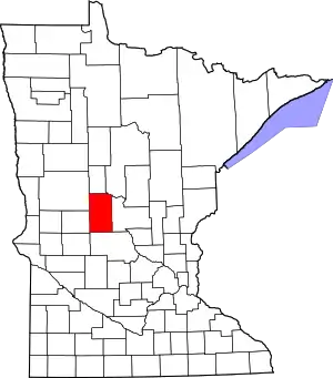 Location within the U.S. state of Minnesota | |
 Minnesota's location within the U.S. | |
| Coordinates: 46°04′N 94°54′W | |
| Country | |
| State | |
| Founded | February 20, 1855 (created) January 1, 1867 (organized) |
| Named for | John Blair Smith Todd |
| Seat | Long Prairie |
| Largest city | Long Prairie |
| Area | |
| • Total | 980 sq mi (2,500 km2) |
| • Land | 945 sq mi (2,450 km2) |
| • Water | 35 sq mi (90 km2) 3.5%% |
| Population (2010) | |
| • Total | 24,895 |
| • Estimate (2019) | 24,664 |
| • Density | 25.9/sq mi (10.0/km2) |
| Time zone | UTC−6 (Central) |
| • Summer (DST) | UTC−5 (CDT) |
| Congressional district | 7th |
| Website | www |
History
The county was created by the Minnesota Territorial legislature on February 20, 1855, although the county government was not organized until January 1, 1867, with Long Prairie as the county seat. It was named for John Blair Smith Todd, who was a delegate from Dakota Territory to the United States House of Representatives, and general in the Union Army during the American Civil War.[3]
Geography
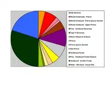
The Crow Wing River flows southeastward along the northeastern border of Todd County. The Long Prairie River flows east-northeast through the upper eastern part of the county, discharging into the Crow Wing on the county's northeastern border. The county terrain consists of rolling hills, dotted with lakes and etched with drainages. The area is devoted to agriculture.[4] The terrain slopes to the east and south, with its highest point on the west border at 1,483' (452m) ASL.[5] The county has a total area of 980 sq mi (2538 km2), of which 945 sq mi (2448 km2) is land and 35 sq mi (90.7 km2)(3.5%) is water.[6]
Major highways
Adjacent counties
- Wadena County (north)
- Cass County (northeast)
- Morrison County (east)
- Stearns County (south)
- Douglas County (west)
- Otter Tail County (northwest)
Lakes[4]
- Bass Lake
- Beauty Lake
- Big Birch Lake (part)
- Big Lake
- Big Swan Lake
- Buckhorn Lake
- Bunker Lake
- Cedar Lake
- Charlotte Lake
- Coal Lake
- Fairly Lake
- Fawn Lake
- Felix Lake
- Goose Lake
- Guernsey Lake
- Hayden Lake
- Jhergens Lake
- Keller Lake
- Lady Lake
- Lake Osakis (part)
- Latimer Lake
- Lawrence Lake
- Little Birch Lake (part)
- Little Sauk Lake
- Long Lake (Birchdale Twp.)
- Long Lake (Burnhamville Twp.)
- Maple Lake
- Mary Lake (part)
- McCarrahan Lake
- Mill Lake
- Mud Lake
- Pauley Lake
- Pendergast Lake
- Pine Island Lake
- Rice Lake
- Sauk Lake (part)
- Schreiers Lake
- Sheet Lake
- Trace Lake
- Twin Lakes (part)
- West Union Lake
Protected areas[4]
- Aurzada Wildlife Management Area
- Buckhorn Lake State Wildlife Management Area
- Burleene State Wildlife Management Area
- Dower State Wildlife Management Area
- Elgin Woods Wildlife Management Area
- Iona Wildlife Management Area
- Ireland State Wildlife Management Area
- Long Prairie River Wildlife Management Area
- Oak Ridge State Wildlife Management Area
- Ojakis Wildlife Management Area (part)
- Owen-Hinz Wildlife Management Area
- Quistorff Wildlife Management Area
- Randall State Wildlife Management Area
- Santer Wildlife Management Area
- Sheet Lake Wildlife Management Area
- West Union Wildlife Management Area
Demographics
| Historical population | |||
|---|---|---|---|
| Census | Pop. | %± | |
| 1860 | 430 | — | |
| 1870 | 2,036 | 373.5% | |
| 1880 | 6,133 | 201.2% | |
| 1890 | 12,930 | 110.8% | |
| 1900 | 22,214 | 71.8% | |
| 1910 | 23,407 | 5.4% | |
| 1920 | 26,059 | 11.3% | |
| 1930 | 26,170 | 0.4% | |
| 1940 | 27,438 | 4.8% | |
| 1950 | 25,420 | −7.4% | |
| 1960 | 23,119 | −9.1% | |
| 1970 | 22,114 | −4.3% | |
| 1980 | 24,991 | 13.0% | |
| 1990 | 23,363 | −6.5% | |
| 2000 | 24,426 | 4.5% | |
| 2010 | 24,895 | 1.9% | |
| 2019 (est.) | 24,664 | [8] | −0.9% |
| US Decennial Census[9] 1790-1960[10] 1900-1990[11] 1990-2000[12] 2010-2019[1] | |||
2000 census
As of the 2000 United States Census,[13] there were 24,426 people, 9,342 households, and 6,511 families in Todd County. The population density was 25.8/sqmi (9.98/km2). There were 11,900 housing units at an average density of 12.6/sqmi (4.86/km2). The racial makeup of the county was 97.54% White, 0.11% Black or African American, 0.48% Native American, 0.31% Asian, 0.01% Pacific Islander, 0.72% from other races, and 0.82% from two or more races. 1.90% of the population were Hispanic or Latino of any race. 52.1% were of German, 11.3% Norwegian and 5.6% Polish ancestry.
There were 9,342 households, out of which 31.80% had children under the age of 18 living with them, 59.80% were married couples living together, 6.10% had a female householder with no husband present, and 30.30% were non-families. 26.30% of all households were made up of individuals, and 13.00% had someone living alone who was 65 years of age or older. The average household size was 2.58 and the average family size was 3.14.
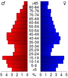
The county population contained 27.40% under the age of 18, 8.10% from 18 to 24, 24.70% from 25 to 44, 23.80% from 45 to 64, and 16.10% who were 65 years of age or older. The median age was 38 years. For every 100 females there were 101.80 males. For every 100 females age 18 and over, there were 102.00 males.
The median income for a household in the county was $32,281, and the median income for a family was $39,920. Males had a median income of $28,630 versus $20,287 for females. The per capita income for the county was $15,658. About 9.60% of families and 12.90% of the population were below the poverty line, including 14.60% of those under age 18 and 13.50% of those age 65 or over.
Amish
Todd County has a large concentration of Amish, about the same population size as the Amish settlement at Harmony.[14] It is home to five different Amish communities, with altogether seven church districts in 2013, which indicates a total population of about 1000 people.
| Location | Founded in | Church dis- tricts in 2013 |
Affiation |
|---|---|---|---|
| Bertha/Hewitt | 1973 | 1 | Swartzentruber |
| Long Prairie/Osakis | 1995 | 2 | |
| Clarissa/Browerville | 2001 | 2 | |
| Bertha/Staples | 2003 | 1 | Swartzentruber |
| Eagle Bend | 2007 | 1 |
Communities
Cities
- Bertha
- Browerville
- Burtrum
- Clarissa
- Eagle Bend
- Grey Eagle
- Hewitt
- Long Prairie (county seat)
- Osakis (partly in Douglas County)
- Staples (partly in Wadena County)
- West Union
Unincorporated communities
Government and Politics
Todd County voters tend to vote Republican. In 71% of national elections since 1960, the county selected the Republican Party candidate (as of 2016).
| Year | Republican | Democratic | Third parties |
|---|---|---|---|
| 2016 | 70.8% 8,485 | 23.2% 2,783 | 6.1% 725 |
| 2012 | 56.9% 6,719 | 40.8% 4,819 | 2.3% 265 |
| 2008 | 54.2% 6,637 | 43.1% 5,277 | 2.8% 343 |
| 2004 | 56.9% 6,945 | 41.2% 5,034 | 1.9% 235 |
| 2000 | 54.4% 6,031 | 37.3% 4,132 | 8.4% 929 |
| 1996 | 38.1% 4,078 | 42.2% 4,520 | 19.7% 2,103 |
| 1992 | 35.9% 3,990 | 36.6% 4,059 | 27.5% 3,055 |
| 1988 | 52.4% 5,633 | 46.7% 5,023 | 0.9% 94 |
| 1984 | 58.3% 6,585 | 41.2% 4,657 | 0.6% 63 |
| 1980 | 53.3% 6,451 | 41.1% 4,975 | 5.7% 685 |
| 1976 | 38.0% 4,278 | 58.1% 6,530 | 3.9% 440 |
| 1972 | 53.1% 5,387 | 42.1% 4,270 | 4.7% 480 |
| 1968 | 51.6% 4,883 | 42.2% 3,992 | 6.2% 585 |
| 1964 | 41.3% 4,006 | 58.5% 5,673 | 0.2% 23 |
| 1960 | 50.9% 5,255 | 48.9% 5,051 | 0.3% 28 |
| 1956 | 56.5% 5,075 | 43.2% 3,882 | 0.3% 24 |
| 1952 | 65.9% 6,731 | 33.7% 3,439 | 0.4% 41 |
| 1948 | 43.7% 4,166 | 54.1% 5,157 | 2.2% 212 |
| 1944 | 59.4% 5,636 | 40.1% 3,803 | 0.6% 54 |
| 1940 | 57.7% 6,302 | 41.7% 4,553 | 0.6% 61 |
| 1936 | 37.8% 3,780 | 56.3% 5,627 | 6.0% 595 |
| 1932 | 33.2% 3,114 | 64.2% 6,023 | 2.7% 250 |
| 1928 | 59.8% 5,682 | 39.3% 3,733 | 0.9% 85 |
| 1924 | 53.0% 4,441 | 6.7% 557 | 40.4% 3,381 |
| 1920 | 71.1% 5,448 | 19.1% 1,464 | 9.8% 750 |
| 1916 | 44.5% 1,919 | 44.6% 1,922 | 10.9% 471 |
| 1912 | 27.8% 1,038 | 28.6% 1,068 | 43.7% 1,633 |
| 1908 | 57.4% 2,334 | 32.1% 1,305 | 10.6% 429 |
| 1904 | 74.8% 2,961 | 18.7% 741 | 6.4% 255 |
| 1900 | 56.3% 2,212 | 37.8% 1,487 | 5.9% 231 |
| 1896 | 52.3% 2,043 | 44.5% 1,739 | 3.2% 126 |
| 1892 | 42.1% 1,251 | 37.6% 1,118 | 20.3% 603 |
| Position | Name | District | Next Election | |
|---|---|---|---|---|
| Commissioner | Barb Becker | District 1 | 2020 | |
| Commissioner and Chairperson | Gary Kneisl | District 2 | 2022 | |
| Commissioner | Rod Erickson | District 3 | 2020 | |
| Commissioner | David Kircher | District 4 | 2022 | |
| Commissioner | Randy Neumann | District 5 | 2020 | |
| Position | Name | Affiliation | District | |
|---|---|---|---|---|
| Senate | Paul Gazelka[18] | Republican | District 9 | |
| House of Representatives | John Poston[19] | Republican | District 9A | |
| House of Representatives | Ron Kresha[20] | Republican | District 9B | |
| Position | Name | Affiliation | District | |
|---|---|---|---|---|
| House of Representatives | Collin Peterson[21] | Democrat | 7th | |
| Senate | Amy Klobuchar[22] | Democrat | N/A | |
| Senate | Tina Smith[23] | Democrat | N/A | |
References
- "State & County QuickFacts". United States Census Bureau. Retrieved September 1, 2013.
- "Find a County". National Association of Counties. Retrieved June 7, 2011.
- Upham, Warren (1920). Minnesota Geographic Names: Their Origin and Historic Significance. Minnesota Historical Society. p. 543. Retrieved March 14, 2019.
- Todd County MN Google Maps (accessed 14 March 2019)
- "Find an Altitude/Todd County MN" Google Maps (accessed 14 March 2019)
- "2010 Census Gazetteer Files". US Census Bureau. August 22, 2012. Archived from the original on October 6, 2014. Retrieved October 25, 2014.
- Nelson, Steven (2011). Savanna Soils of Minnesota. Minnesota: Self. pp. 53-56. ISBN 978-0-615-50320-2.
- "Population and Housing Unit Estimates". Retrieved March 26, 2020.
- "US Decennial Census". United States Census Bureau. Retrieved October 25, 2014.
- "Historical Census Browser". University of Virginia Library. Retrieved October 25, 2014.
- "Population of Counties by Decennial Census: 1900 to 1990". US Census Bureau. Retrieved October 25, 2014.
- "Census 2000 PHC-T-4. Ranking Tables for Counties: 1990 and 2000" (PDF). US Census Bureau. Retrieved October 25, 2014.
- "U.S. Census website". US Census Bureau. Retrieved January 31, 2008.
- "Minnesota Amish". amishamerica.com. Retrieved October 10, 2018.
- Donnermeyer, Joe; Luthy, David (October 21, 2019). "Amish Settlements across America: 2013". Journal of Amish and Plain Anabaptist Studies. 1 (2): 107–129. ISSN 2471-6383.
- Leip, David. "Atlas of US Presidential Elections". uselectionatlas.org. Retrieved October 10, 2018.
- "Meet Your Commissioners | Todd County Board of Commissioners". Todd County, Minnesota. Retrieved June 26, 2020.
- "MN State Senate". www.senate.mn. Retrieved June 26, 2020.
- "Rep. John Poston (09A) - Minnesota House of Representatives". www.house.leg.state.mn.us. Retrieved June 26, 2020.
- "Rep. Ron Kresha (09B) - Minnesota House of Representatives". www.house.leg.state.mn.us. Retrieved June 26, 2020.
- "Congressman Collin Peterson". Congressman Collin Peterson. Retrieved June 24, 2020.
- "U.S. Senator Amy Klobuchar". www.klobuchar.senate.gov. Retrieved June 24, 2020.
- "Home". Senator Tina Smith. Retrieved June 24, 2020.
External links
Places adjacent to Todd County, Minnesota | ||||||||||
|---|---|---|---|---|---|---|---|---|---|---|
| ||||||||||
Municipalities and communities of Todd County, Minnesota, United States | ||
|---|---|---|
| Cities | Map of Minnesota highlighting Todd County | |
| Townships | ||
| Unincorporated communities | ||
| Footnotes | ‡This populated place also has portions in an adjacent county or counties | |
| ||

| Authority control |
|---|